
-
 13129 Hits
-
 86.37% Score
-
 22 Votes
|
|
Mountain/Rock |
|---|---|
|
|
44.50833°N / 121.87194°W |
|
|
Linn |
|
|
Hiking |
|
|
Spring, Summer, Fall |
|
|
5848 ft / 1782 m |
|
|
Overview
With a name like Red Butte, this peak in the Mt. Jefferson Wilderness area of central Oregon may seem uninspiring but this hikeable summit lies in the Eight Lakes Region just northwest of Three Fingered Jack which means you get great views of that Cascade classic and a pleasant hike among beautiful bodies of water. The view of Three Fingered Jack is one that most never see as the standard route for climbers and the main highway for passersby in the area lie to the south while Red Butte is on the NW flank of that Cascade volcano. You also get views of volcanoes from Broken Top to Jefferson.
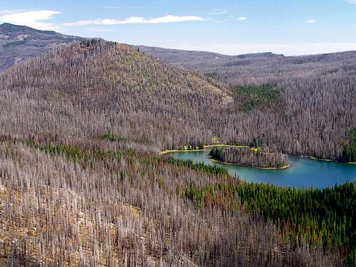
The area is also unique in that in 2003, the B & B Complex Fire, burned much of the area. As a result, much of the forest on Red Butte was lost. The combination of green forest and charred black snags create an eery landscape, especially if you hike cross country from nearby Duffy Butte.
Red Butte also towers over the north edge of Mowich Lake, a great lake with a sandy beach and a large forested island. It is a great place to camp and could be a nice family hike as the elevation gain is only 1800 feet (although the round trip mileage is almost 12 miles).
There are a couple ways to get to the summit of this peak. There is a nice trail system leading around Duffy Butte on the east past Mowich Lake to small Alice Lake where one can find a way up the eastern flank of Red Butte, or, you could summit Duffy Butte on your way in and go cross country down the northeast side of Duffy and up the western side of Red Butte. Both will be 11.8 miles round trip with but you get 700 more feet of loss then gain with the latter.
Don't get confused with other Red Buttes in Oregon (and more still in other states). This one is located off Highway 22/20 near Detroit, OR and is not the one found near the Idaho border, or the one in the Umpqua National Forest or the one in SE Oregon near Nevada. The naming of peaks in Oregon may be lacking in originality but it is easy to see how this one got its name. The summit of this cinder cone is tinged reddish-orange with volcanic debris. And until the trees regenerate, it will be that way for a while to come.
Obsidians Trip Report with more photos of the peak and area
Another photo site of the area with emphasis on the fire damage
Getting There

From Portland/Salem, take I-5 south to Highway 22 east. Take Hwy 22 about 76 miles east. Near milepost 76, turn left onto Big Meadows Road and follow it about 3 miles to the end at the trailhead. There is one fork to the left that is marked with a sign to the Duffy Lake Trailhead.
From Eugene, you would take Highway 126 east to Highway 20. Turn right on Hwy 20 and go a few miles to the Santiam Junction of Highways 20 and 22. Turn left onto Hwy 22 and proceed to the same Big Meadows Road which will be on your right near milepost 76.
From Bend, take Highway 20 to Highway 22 and proceed as above.
Red Tape
A Northwest Forest Pass is required to park at the trailhead.In addition, a Wilderness Permit is reuired to be completed and carried with you. These are available free at the trailhead.
Camping
There are established campgrounds at both Duffy and Mowich Lakes on the eastern flanks of Duffy Butte. Camp only in designated sites. Do not go into recovery areas. Campfires are prohibited. The trail in will take you right to these areas.When To Climb
June to November is best. The trailhead is at 4050 feet so snow will be the deciding factor if you can get to the trailhead. Since Highway 22 is plowed through the winter, you could conceivably pull off and park at this road and hike in from wherever you can get but I don't have any idea if this area is patrolled to tow cars. I wouldn't think so but who knows....Keep in mind that this is the Eight Lakes Wilderness Area and Spring can be very buggy.
Mountain Conditions
Detroit Ranger DistrictHC73, Box 320
Mill City, OR 97360
503-854-3366
FAX 503-854-4239
Summer hours: 7 days a week 8-4:30 Memorial Day - Columbus Day
Regular hours: Monday-Friday 8-4:30
Recreation Update
Detroit, OR Weather
Other Weather Source
Things to keep in mind in this area:
There are bear, cougar and rattlesnakes in the area.
The fire burned badly here and in places it burned the roots underground. This created gaps in the sandy soil and may cause you to sink in in areas that are not established trails. Be careful where you step.
The small branches on trees burn into a spiked shape creating sharp thorns at the least and dangerous impaling spears at the worst. Watch your step so you don't fall into one.
Blue green algae dangers in the lakes