Venturing off the beaten path
![Waterfall]() Waterfall
Waterfall
Another planned hike to somewhere 'other' than the Sawtooth area gave me the choice of the Lowman area. I figured I'd like to stay away from the typically crowded Sawtooth/White Cloud area, so Margaret Fuller's
'Trails of Western Idaho' book gave me a couple options, of which I chose the Red Mountain area. Waking up Saturday morning at 5:00, we were out the door by 5:30, stopped to get gas and we were on our way. The drive up was pretty uneventful, with the only highlight being my daughter's creepy half-open eyes/mouth while she succumbed to a deep sleep. Once in Lowman, we made a left to follow a creek along a dirt road for roughly 20 miles. Finally, we arrived at the trailhead at 8:00 and we were off!
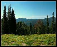
![Open Meadow]() Open Meadows
Open Meadows
The forecast for the day predicted 100 degree weather at home, so an early morning start was crucial for our success. Even at 8:00 in the morning you could tell it was gonna be a hot one, but thankfully the mountain was only roughly 4.7 miles away. 20 minutes into the hike, the trail crosses the creek over a nice bridge. This point offered a nice view of a small waterfall cascading down the mountain.
The creek requires two more crossings, which were navigated by stepping on exposed rocks that led to the other side of the creek. Once crossing, the trail then starts winding uphill for a grueling 2,560ft climb to the summit. Fortunately most of the climbing was done under the shade of the forest canopy, and had it not been for that fact we may have been forced to turn back. On top of this ridge, the trail then travels through some open meadows with great views of the mountains while the scent of wildflowers filled the air.
![Reaching the Summit]() Nearing the summit!
Nearing the summit!
At 3 miles from the trailhead, the trail splits. Right takes you along the Kirkham Ridge Trail, which circles around Red Mountain and drops down to the lakes below (eventually this trail leads to Cat Lakes). Left takes you an additional 1.5 miles to the Red Mountain Summit. Reaching this area was a moral booster for the rest of the team since the climb up to this point was a 'death march'. "Only 1.5 miles to go!" I barked, only to have rolling eyes and sighs of discouragement be the response. Heheheh!
By this time the heat of the day was starting to be felt and we starting to get into the more 'open' areas that did not have any shade to rest under. We'd find some shade, rest, then trudge uphill to the next sliver of shade offered by a strategically placed tree. Everyone was getting fatigued and the trail seemed to get steeper and hotter, ugh! As we slowly and steadily kept climbing, the views kept getting better and better. Finally, my heart raced as the treeline got lower and eventually disappeared. The summit of Red Mountain was now visible:
![Enjoyment on the Summit]() Yours Truly
Yours Truly![Cakes]() Cakes enjoying the summit
Cakes enjoying the summit
Scrambling up to the top, we reached the old foundation for the lookout tower which used to sit atop Red Mountain. It is no longer there, but does offer a nice flat area to kick the packs off and enjoy the views. From the summit, 5 lakes are in view with another out of sight behind a ridgeline that trailed off to the right. In the distance the Sawtooth Mountains can be seen, with areas of the Whiteclouds that can be seen on a clear day. Here we soaked in the scenery for about 45 minutes and had another PB&J to celebrate our hard work before heading back down.
Logistics
To put into perspective the amount of climbing we did, here's the specs for a simple Table Rock jaunt:
Table Rock climb =
825 ft elevation gain
3 mile round trip
Takes approx 45 minutes to complete
Red Mountain climb =
2,560 ft elevation
9.5 mile round trip
Took 3.5 hours to climb, 5.5 hours total
![Red Mountain Lakes]() Red Mountain Lakes
Red Mountain Lakes
Comments
No comments posted yet.