
-
 12103 Hits
-
 82.47% Score
-
 15 Votes
|
|
Mountain/Rock |
|---|---|
|
|
37.18724°N / 113.6703°W |
|
|
Washington |
|
|
Spring, Fall, Winter |
|
|
4779 ft / 1457 m |
|
|
Overview
Red Mountain is a plateau within the Red Mountain Wilderness Area extending from Highway 18 9.5 miles south its southern terminus in Ivins, UT. The Red Mountain Trail, which begins off of Highway 18, has a couple of scenic overlooks and gains about 400' from the trailhead to the high point and is suitable for hikers and equestrians alike. While not a very strenuous hike, some parts of the trail stretch through deep patches of sand, and the official trail peters out after about 6 miles. Individuals should be comfortable with route finding. Having a topomap on hand isn't a bad idea, and following tracks is probably a bad idea - they often lead nowhere.
Individuals can continue on to approach the southern terminus of the plateau to take in glorious, red rock-laden views of Washington County (Signal Peak!), Zion National Park, Nevada, and Arizona and then turn back for a less difficult out-and-back. Alternatively, they can forge south and attempt the much more strenuous and technical descent into Ivins, UT via the Gunsight or Red Mountain Trails (loss of ~1500' over ~1/4 mile).
Extra ambitious folk can also achieve the plateau by starting at the Ivins or Gunsight Trailheads instead of the Red Mountain Trailhead. These routes are littered with tracks and cairns, but it should be stressed that there is no maintained trail. The route to the top is not officially marked, and while cairns and tracks might lay conveniently in your sights, they could easily lead you astray. Steep trails with loose rock mean that the mountain will change with each rain. Exercise caution, and make sure that you're comfortable with route finding before setting out. These routes include considerable scrambling and exposure.
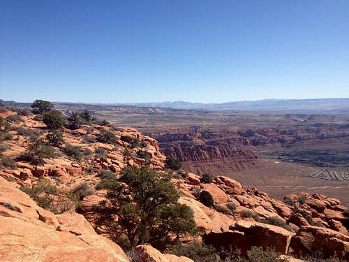
Looking east from Red Mountain
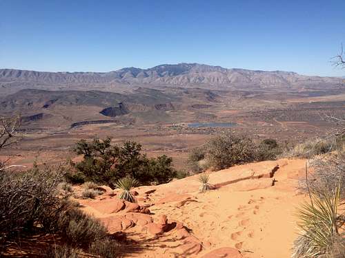
Looking west from Red Mountain
Getting There
To the Red Mountain Trailhead: From I-15 in St. George, take the Bluff Street exit North to Rt. 18. Continue North past the communities of Winchester Hills and Diamond Valley. From Diamond Valley Drive on your right, go about 2 ½ miles and look left for a small paved road that turns to dirt at the fence line. Take this left hand road into the parking area for the Red Mountain Trailhead. If you come to a power substation on the left, you have gone too far.To the Gunsight Trailhead: From 1-15 in St. George, take Exit 8/St. George Blvd toward Rt. 18. Turn west onto E St. George Blvd/100 N and then north onto 900 E. Turn west onto Red Hills Pkwy and continue for about 3.5 miles. After crossing N Bluff Rd, Red Hills Pkwy becomes Snow Canyon Pkwy. Continue through the first traffic circle. At the second traffic circle, take the first exit onto Snow Canyon Dr. Take an immediate left onto Tuacahn Dr., and continue for ~0.9 mile. The trailhead will be on the left.
To the Ivins Trailhead: From 1-15 in St. George, take Exit 8/St. George Blvd toward Rt. 18. Turn west onto E St. George Blvd/100 N and then north onto 900 E. Turn west onto Red Hills Pkwy and continue for about 3.5 miles. After crossing N Bluff Rd, Red Hills Pkwy becomes Snow Canyon Pkwy. After about another 4 miles (you'll pass through two traffic circles), Snow Canyon Pkwy becomes E Center St - continue for another mile, until you come to a third traffic circle. Take the 1st exit onto N 200 E. The parking lot for the trailhead is at the end of the road.
This is a popular trail for hikers and horseback riders. It follows dirt roads and smaller, harder to follow sections of trail with slick rock areas, into a remote area of the Red Mountain Wilderness. Park at the trailhead, and walk up the trail, past the fenced section. Continue on the trail as it winds up through rocky country covered with a thick Pinyon Juniper forest. At 1.8 miles, note the sign for the Snow Canyon Overlook. This short trail through deep sands takes you to a spectacular view from above the north end of Snow Canyon. From the main trail, continue on as you eventually drop down and head South, along the ridge above Snow Canyon. You will then come to a section that enters a sage flat with deep sand, heading gradually downhill. If you continue on, you will come to the southern edge of the plateau, and start a steep decent down to the junction with the Toe Trail North of Ivins. Note that the descent down into Ivins is not suitable for equestrians