
|
|
Mountain/Rock |
|---|---|
|
|
37.85360°N / 116.1358°W |
|
|
Nye |
|
|
Hiking |
|
|
Spring, Summer, Fall |
|
|
8812 ft / 2686 m |
|
|
Overview
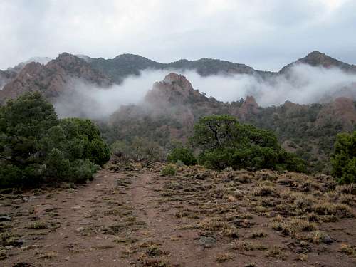
Morning mist
Located just north of area 51 in Nevada, Reveille Peak is isolated but attractive to peakbaggers. Off the beaten path, this one will whet the appetite of anyone who loves to get away from it all and enjoy true Nevada outback. The nearest wide spot in the road is Rachel, famous for its popularity with those who are traveling the Extraterrestrial highway. On the link for Rachel, be sure to click on the history section, it is well worth a read. Now back to the peak.
With a prominence of over 2600 feet, Reveille Peak comes in as the 89th top prominence peak in Nevada and while there aren't many people chasing Nevada prominence peaks, its prominence does attract a few, more and more recently. The register atop the peak shows that most of the visitors to the summit have been in the past two years with 8 entries and only a few entries in all the years prior. A navy seal team climbed the peak in 1975 and a group from Nellis Air Force base called the interceptors made a trip in 1999. Other than a few hunters and a local rancher or two, less than a dozen peakbaggers have been to the top of this one. I'm sure that providing the information that I'm providing on this summitpost page might attract a few more and if you're one of them, please read the disclaimer at the bottom of this page. The information here is just that, information, it is not intended to be a sure fire guide but when you consider that most of these Nevada peaks are really unknown, I'm doing my best to help those of you crazy enough to be a Nevada prominence peakbagger. If you don't know what prominence is or don't care, this mountain is still worthy of a visit as just getting to its base is an adventure in traveling in the Nevada outback.
How did Reveille Peak get its name you might wonder? Perhaps a cavalry man sounding Reveille on his trumpet in the area at one time? I wondered so I started looking and found the answer in the book "Nevada Place Names" by Helen Carlson. A mining camp was established in the area in 1866 and a member of the party that found the mineral deposits was the editor of the Reese River Reveille, a newspaper up in Austin, and he named the peak and the area after his newspaper. That newspaper was the oldest continuously published newspaper in Nevada up until 1993 when it ceased publication after 130 years. A bit of history was found HERE and I'll reproduce it for you:
"The Reese River Reveille was first published in Austin on May 16, 1863. Its fortune rose and fell with the mines and merchants of Austin. It ceased publication in 1993.
At times it was a weekly newspaper, and other times a daily. Nonetheless, its hardworking editors and publishers were among the leading newspapermen of the era. Some published highly referenced history books such as Myron Angel and his "1881 History of Nevada" while others published tall tales of Austin's everyday life, as in Fred Hart's "The Sazerac Lying Club (1871) and "The Town That Died Laughing" (1958) by Oscar Lewis.
The paper was a lively chronicle of a western town over a span of 130 years. The Reese River Reveille was revived in 2004 and is published quarterly in Austin once again. It blends stories from its rich archives with articles relating to current and historical events, adds a bit of humor, and provides a look into the restoration efforts in Austin and Central Nevada."
Getting There

Highway 375
From Las Vegas:
From Las Vegas take I-15 north for 22 miles. At exit 64 take US-93 north. After 85 miles, 12 miles past Alamo, you come to the intersection with Hwy. 318 on the left. At the intersection turn left onto Hwy. 318, and after less than a mile veer left again onto Hwy. 375. At that intersection you will see the "Extraterrestrial Highway" sign under a group of trees on the right. From here it is about 40 miles north-west to Rachel. Rachel has a small cafe with a chance for a sandwich and an ice cream treat possible. Continue past
Rachel (no gas as last gas is in Ash Springs 50 miles back)and continue on highway 375 till you hit a junction with a road marked for Cedar Gate. (37.7613 115.9806) This is a short distance north of milepost 44. Go west for 8.8 miles and turn right (north) by an abandoned ranch & corral (37.7537 116.1286). Follow the dirt road for roughly 8 miles to Willow Witch Well on your right (37.8411 116.2095). At the well take the fair road east of the well about 3.5 miles up to the base of the mountain where the road end. This is OK for most vehicles but high clearance would be useful although 4WD wasn't necessary when we drove it.
From Tonopah and Ely
The west side of the mountain can be reached from Tonopah by driving east on route 6 or from Ely by driving west to the junction with highway 375. Turn south and then go a short distance on route 375 and turn south on the graded dirt road in Reveille Valley. It is 28 miles on the dirt road to Willow Witch Well. Overall, this road wasn't bad except for the occasional rut or small washout that you need to slow way down for. You could stay on highway 375 until you reach the turnoff mentioned above for Cedar Gate, but this adds a lot of miles although most of your drive will be on pavement by going this way.
 Witches Well turnoff Witches Well turnoff |  Road from Witches Well to TH Road from Witches Well to TH |  Inspecting the end of the road area Inspecting the end of the road area |
Route
Dennis and I approached the mountain from the west side per directions gleaned from Richard Carey's trip report (see links below). From where we parked at the end of the road, we just headed directly for the summit as recorded on our GPS. The hike was straight forward, first dropping down about 40 ft through a drainage and then up a steep slope through a gap between a large rocky outcropping in the left and a pointed rock on the right.Once up to this gap it was a simple process of picking a route between the trees and boulders up a steep slope to the summit. In order to avoid some loose slopes and talus, we got too far to the left on the ridgeline and we were climbing over boulders and rocks and even a couple class 3 spots. That wasted time and wasn't necessary so we soon found our selves on the slopes leading up to the summit and we found no more difficulties and easy up to the summit itself.
The summit had a cairn of rocks on it which also contained a register, a glass jar inside of a red can (the red can is a Richard Carey contribution). We also found a central benchmark and a witness marker nearby. Normally we would have had great views but the clouds in the area kept our views to a minimum. We weren't able to see much to the south where a storm had been fairly active. On the descent we stayed a little further out on the slope and you can see the route we picked if you'll look at Dennis's GPS track or that of Ken Jones as posted on peakbagger. One negative of the route would be the loose talus on the final 500 feet or so giving you one of those two steps up, one step down situations.
Elevation gain from where we parked was close to 1800 feet in less than a mile and a half. It seems crazy to drive so far but yet have such a short hike but oftentimes in Nevada, the adventure is in the getting there. One of the things you could do is to include hikes to nearby peaks such as Kawich, Worthington, or the highpoint of the Quinn Canyon range
 The route heads up The route heads up |  Checking our route position Checking our route position |  On top On top |
Summit Register:
Unfortunately, the pics I took of the register were lost when I lost my camera during a descent of Blue Eagle Peak a few days later. However, I do remember that the original register was placed by Gordon MacLeod and Barbara Lilley in May of 1994. I also remember that the next signee that I knew was John Vitz, 10 years later, also in May, 2004. By checking peakbagger.com and lists of John, others wouldn't reach the summit for another 8 years . Three people from 1994 to 2012. Amazing. Then Bob Sumner in 2012 and in 2013, 8 more of us reached the top. If it wasn't for prominence, few would visit this lonely and isolated mountain.
Red Tape

Reveille Peak Benchmark
As this mountain is on BLM land, refer to the BLM website.
BLM Battle Mountain District Office
50 Bastian Road | Battle Mountain NV 89820 |
775-635-4000
Office Hours: 7:30 am - 4:30 pm M-F
Cattle may be encountered as they are allowed to graze on BLM land and there might also be private land intermixed with BLM. Wild horses also can be found in the area. An interesting webpage exists for wild horse management.
While driving on highway 375 realize that most of it is open range. There are no fences, and cows frequently wander across the road. When you see cows near the road slow down and be prepared to stop. Be especially careful at night, when cows on the road are very hard to see. Running into a cow will not only cause severe damage to your vehicle, but you will also have to reimburse the rancher for the cow. This is true of most Nevada back roads too. Don't hit a cow, it can be very expensive and disastrous.
When to Climb
Whenever there is good weather and the roads are not muddy. It is possible that this might be accessible all year round but it depends on whether the area gets a lot of snow or not, which varies from year to year in this area of Nevada.While in this section of Nevada, you might want to consider adding Kawich, Rawhide, Worthington or Quinn Canyon peaks to your agenda. If you do so, be sure to have enough gas to allow you to accomplish this. All are isolated and getting to Worthington and Quinn Canyon area peaks are many many miles of dirt road to deal with. Rawhide isn't too many miles from the pavement of US 6 near the junction of US 6 and Highway 375 at Warm Springs Junction.
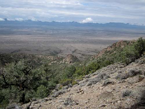
 Looking east Looking east |  Looking south towards Area 51 Looking south towards Area 51 |  Looking northerly Looking northerly |
Rachel Nevada is the closest place for weather purposes:

Click for weather forecast

Click for weather forecast
Camping
Route Down
There are no campgrounds in the area but car camping and minimal impact camping is allowed on BLM land. Pack out all your garbage and leave no rock rings or evidence that you were there. Often you can find spots where it was obvious that others had camped before but always do your best to not impact the area you are camping in. If you find trash or garbage left by others, do the right thing and pack it out as well as your own garbage. The nearest town that has motels would be Tonopah, a good 80 miles away.
Notes and comments
We had been dodging bad weather during our visit but we were able to find dry roads during our visit. As we often do while bagging these isolated desert peaks, we car camped at the end of the road and got ready for the hike the next morning. During the night, another storm blew in from the northwest and really rained heavily for several hours. Fortunately for us, by the time we finished the hike the roads leading out had dried out sufficiently to allow us decent driving on the 28 mile section back to US 6.Many thanks to Dennis Poulin for his generous use of his pictures for this page. I lost my camera with all the pics I had taken on Blue Eagle Mountain and it contained all the pics from a rather lengthy trip
Rarely climbed: Peakbagger.com shows only 3 ascents by known peakbaggers from 1975 to 2004, then an ascent by Bob Sumner in 2012. 2013 was a banner year with 9 prominence peakbaggers climbing this one (includes Sarah Martin).
Richard Carey's Trip report
Weather & Warning
Weather for Rachel area: LINK----------------------------------------------
----------------------------------------------
This is a very isolated area and while you might see some cattle, you might not see many people. Cell coverage in this part of Nevada is spotty and often non existant. We did have cell coverage in Rachel but that was about it. Make sure your vehicle is in good working order and that your tires are able to withstand rocks and hazards of the off roading you will need to do. Top off your gas tank in Ash Springs or Tonopah. Carry plenty of water and supplies in case of a breakdown as well as a good spare tire. Preferably, going with another vehicle in this part of Nevada is always a good plan. I can't guarantee your success or that you will even find the right roads so consider the information I've provided as an attempt to entertain you but not be a step by step guide. You are responsible for whatever occurs on chasing this mountain and I wish you success and good luck at the same time. The Benchmark map book for Nevada is a good investment and good topo's are smart to have as well.
Also, beware of aliens and alien spacecraft as you travel the Extraterrestrial Highway. Don't become another alien abduction so let others know where you are headed and when to expect to hear from you again.