
-
 8317 Hits
-
 83.1% Score
-
 16 Votes
|
|
Canyon |
|---|---|
|
|
36.67480°N / 105.6816°W |
|
|
Hiking, Trad Climbing, Canyoneering |
|
|
Spring, Summer, Fall |
|
|
Overview
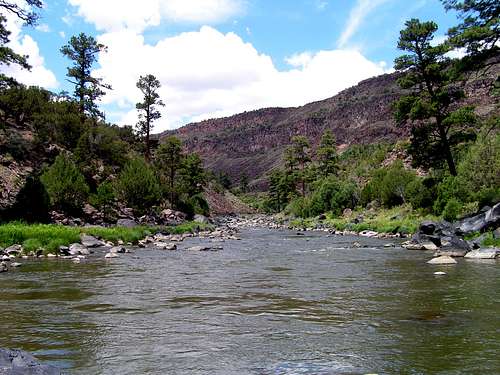
This is an excellent hike descending about 800 feet from the rim of the Rio Grande Gorge. Whether you are on the rim, at the river, or on the trail you will be afforded some of the most spectacular scenery New Mexico has to offer. At the bottom you will find some very relaxing camping without having to hike a long distance. Also, if you like to fish, this area at the convergence of the Rio Grande and Red Rivers is outstanding for trout fishing.

There are five trails originating at campgrounds on the rim which lead down to the Rio Grande or Red River, the shortest being only about 1.6 miles round trip. At the bottom you can also hike several miles of trails along the rivers.
This area is protected by the Wild and Scenic Rivers Act of 1968 which encompasses forty eight miles of the Rio Grande south of the Colorado border and four miles of the Red River. This page focuses on a small portion of this.


Getting There
From Questa, drive north on N.M. 522 for 3.3 miles. Turn left (west) on N.M. 378. Drive 5.5 miles to the boundry of the recreation area, and continue another 6.5 miles to the Big Arsenic Springs Campground and the visitor center.Red Tape
A permit is required for overnight camping on the river when the visitor center is open (Memorial Day to Labor Day)Camping
There are three campgrounds on the rim of the Rio Grande and two on the rim of Red River. From these campgrounds, trails lead down to riverside campgrounds.
Information
Info: Bureau of Land Management, Taos Resource Area: 505-758-8851Weather
Lodging