Ritter a Penultimate Climb
Mount Ritter was more than just another 13’er in the Sierra’s for me. I’m a member of the
County Highpoint Organization and Mt. Ritter is the highpoint of Madera County. The Madera County highpoint was the penultimate (57th) of 58 county highpoints for me in the state of California. California is a large state and some of the county highpoints include impressive peaks such as
Mt. Whitney,
Mt. Shasta,
Mt. Lyell,
North Palisade, and
White Mountain Peak. It also includes some unimpressive peaks like
Little Blue Peak,
Copernicus Peak, and
Carpenter Hill.
I saved 3 beautiful Sierra peaks to be my last 3 climbs to complete the California County Highpoints. I
dayhiked Mt. Lyell in October, 2006 leaving Mt. Ritter and North Palisade to finish the state. The time had come to plan a trip to the Sierra’s and climb these two magnificent mountains. I didn’t want to try North Palisade solo, so I contacted SP’er and fellow County Highpointer
Dan Baxter, who has been weathered off of North Pal the last two years, to see if we could collaborate on the effort. Dan and I had climbed
Mt. Rainier together a couple years ago. Dan only needed North Pal to finish the
California County Highpoints also. Neither one of us are rock climbers, we are more trail hikers. Dan was more than willing to team up, but he wanted to enlist one more member to lead our team. He wanted SP’er
Kurt Wedberg. I had met Kurt earlier this year on
Denali and had the pleasure of hiking with him on summit day. We contacted Kurt and scheduled our North Palisade climb for August 14-17, 2007.
Now, there was only one more problem. I had not yet climbed Mt. Ritter and we wanted North Pal to be our California County Highpoint finishing climb. Dan is such a good friend that he volunteered to climb Mt. Ritter again with me. We devised a plan to climb Mt. Ritter a couple days ahead of North Pal.
The problem was that I had to get a back country camping permit for Saturday, August 11th. On Friday, August 10th I got up at 2:00AM, and was on the rode by 2:30 heading from Medford, Oregon to the Mammoth Lake Visitor Center. I had to get there by 11:00 AM when they start issuing walk-in permits for overnight backpacking in the Ansel Adams Wilderness Area. There are only walk-in permits for 12 people, so I wanted to get there when they opened to maximize my chance of getting a permit. 450 miles later I pulled in to the parking area for the Mammoth Lake Visitor Center. I had 20 minutes to spare.
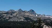
![Mt. Ritter]()
When I got inside the Visitor Center there were lots of hikers getting their reserved permits, but this activity soon came to an end and I was 4th in line for walk-in permits. I waited nervously as more hikers came in and got in line behind me. I asked those ahead of me where they were going and fortunately, they wanted permits for other areas. The couple right behind me wanted a permit to go to Ritter too. Fortunately, the line finally moved and I got up to the counter and I got my permit for Shadow Lake which allowed me to go clear to Mt. Ritter.
![Mt. Ritter]()
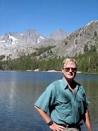
I called Dan on my cell phone and let him know we were good to go. Dan lives in Fresno and doesn’t have near the drive that I just completed. Now, I had another problem. I had to find a place to camp and get all my stuff to the Agnew Meadows Trailhead where Dan would meet me by the next morning. Since the day started well, I took my chance and drove through Mammoth and on to the entry station for Devils Postpile National Monument. Agnew Meadows Campground is down in the valley beyond this entry station and all passenger cars are prohibited from the road past the entry. You must take a shuttle bus from the Mammoth Ski Area to go pass the station. Also, there is a mandatory fee of $7 for all adults.
![Mt. Ritter]()
I told the attendant that I wanted to camp at Agnew Meadows, he said there were only 3-4 sites available and that I was very lucky there were any vacant. He charged me the $7 entry fee and I drove down to Agnew Meadows where I paid another $18 for a campsite. I was set for Mt. Ritter. I had the permit and a campsite for tonight.
It was only about 12:00 noon, so I drove back up to Mammoth, called Dan and told him where I was camped, and he told me I had plenty of time to go for a hike. I asked him what he recommended and he suggested Mt. Dana for a hike and then the restaurant at the Mobil gas station for dinner. I laughed and pictured corn dogs and day old donuts at a Food Mart.
I drove up to Tioga Pass, found the trailhead for Mt. Dana, and went for a nice afternoon hike to the summit. About 20 people passed me coming down, but no one else was going up. After the hike I drove down to the Mobil station (I needed gas anyway) and stopped for dinner. This place was hopping!!! There must have been a hundred people having dinner here. It is the world famous
Whoa Nelli Deli !!!! I had to have the Fish Taco’s and they were superb.
It was just dark now, so I drove back to Mammoth and then down to Agnew Meadows. It had been a long day, so I didn’t have any trouble going to sleep. About midnight I woke up because another car had pulled into my campsite. Dan had found me. I went right back to sleep.
Early the next morning we both drug ourselves out of our sleeping bags and had breakfast. There was no rush to get on the trail today, so we took our time eating, talking, and sorting our gear. We didn’t take a rope or ice axes, but we did bring crampons in case we had to cross the glacier. We ambled out of camp about 10:00AM and headed down the road a couple hundred yards to the trailhead. I let Dan lead since he had climbed Mt. Ritter previously and he climbs in the Yosemite area regularly. Dan set a nice easy pace that I didn’t mind because we were carrying overnight packs.
![Mt. Ritter]()
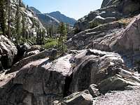
The trail starts nice and easy as it looses a few hundred feet in elevation before it turns west towards Shadow Lake. At the west end of Shadow Lake the trail joins the John Muir Trail westward. There were many more hikers on the trail because this is the middle of the summer tourist season and we were hiking on the world famous John Muir Trail. What an incredibly beautiful area. All too soon the John Muir Trail branched off to the north and we continued westward towards Ediza Lake.
![Mt. Ritter]()
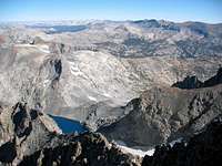
At Ediza Lake we went around the east and south sides and then found a climber’s trail that continued westward towards Mt. Ritter. We continued up the valley following the trail until we were right under Mt. Ritter’s east face, next to the little tarn at about 10,100 ft in elevation. We hiked a little ways east from the creek and found a nice grassy and sandy spot to set up camp. We had a great view of our objective for tomorrow and we got to our campsite early. We set up camp, Dan took a nap, and I watched a marmot run around looking for an opportunity to steal some food.
No fancy dinner, just bags of dehydrated stuff and then we turned in for the night and planned to get up at dawn. At dawn, both of us got up, had a little breakfast, and were hiking before the sun hit our campsite. The climber’s trail was just across the creek from our campsite. We didn’t want to go up to the Banner/Ritter saddle. Instead, we wanted to climb up by the Ritter Glacier on the south side of the summit.
The trail here is a bit obscure, but it is just a steep scree/talus climb up to a bench area. From the bench area, we continued moving up, but started traversing a little northwest to enter the bowl that is south of the summit. I went up an area that was mostly slabs and Dan chose a path lower down that was mostly talus. My route had me crossing over some water coming off the glacier above and it was cold enough to form ice on the granite. No real problem here, but I didn’t challenge the areas that looked slick.
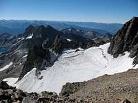
Dan and I met up again at the toe of the Ritter Glacier. We didn’t step onto the glacier because it was rock hard and slick, but instead we stayed right next to it on the talus and continued climbing more to the west now. Our goal was the first chute that took off towards the summit on our right. This chute is easy to find and is not a rock climb. It is a scree/talus steep climb. We were already kicking rocks down to the glacier, so we decided to climb parallel paths. There are lots of options climbing up to a ridge. I was primarily on solid rock whenever possible and Dan took the talus/scree route. We kept our elevation about equal so that when we kicked a rock loose, it didn’t threaten our partner. We kicked lots of rocks loose.
We slowly made our way up to a ridgeline at about 12,500 ft and we were grateful to finally get there. From here, we could finally see the summit clearly and the path was not nearly as steep as the chute coming up from the glacier. The route up to the summit followed a very braided climber’s path that you really can’t get lost on unless there was low visibility. By the time we got to the summit there was a wind blowing and it was cold. I scrambled to put on a windbreaker, my fleece hat, and gloves. We took our obligatory pic’s and had lunch.
I finally had to get off the summit because I was freezing to death. It felt good to get out of the wind and head down. We slowly made our way down from the summit to the chute trying not to kick down too many rocks/boulders, or to fall on our butts. It got worse in the chute. All the rocks moved and I took a good fall. Fortunately, it was backward onto my right hand. I got a big bruise on the heal of my hand and it hurt for a couple of weeks.
It was a challenge not to kick rocks down on each other, but we eventually made it down to the glacier at the bottom of the chute. Right when we got to the glacier, we both started rock falls that were good size. I had to ride some good sized rocks down about 10 feet at one point.
I was thankful when we got away from the glacier and finally found some granite slabs. They didn’t MOVE. I took the lead at this point and found a route that was mostly over granite slabs all the way over to the steep scree slide back down to the creek. At the creek, we met 2 hikers who were heading up. They had watched us come down and wanted to go up the way we came down. They headed up and we went looking for our campsite. It was still relatively early, so we packed up our gear and hiked back out to Agnew Meadows. Why does it always seem so much further hiking out than hiking in? It was even downhill and it seemed further.
Anyway, it was a beautiful day and we just took our time with frequent rest breaks. I took lots of pic’s and it was fun to talk with other hikers on the trail. When we got to Agnew Meadows we packed up our stuff and drove out to Mammoth for dinner. Now we were ready to tackle North Pal. Here is my
Trip Report for North Pal.


Comments
Post a Comment