
-
 6978 Hits
-
 84.68% Score
-
 19 Votes
|
|
Mountain/Rock |
|---|---|
|
|
39.75886°N / 105.88054°W |
|
|
13140 ft / 4005 m |
|
|
Overview
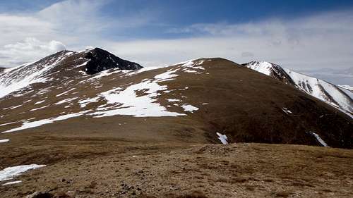
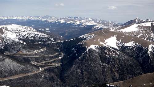
Robeson Peak from top of Engleman Peak.
Englemann Peak from Robeson Peak.
Robeson Peak (13140ft / 4005m)
Unranked
Latitude: 39.7335981 Longitude: -105.8061195
County: Clear Creek
Robeson Peak was named for Soloman Robeson who discovered many of the mines in Clear Creek County Colorado. Because of its lack of prominence (less than a 300 foot drop in the connecting saddle, etc.) Robeson Peak is considered part of Englemann Peak and Bard Peak. Robeson Peak is mostly hiked together with some other 13ers in the area.
Getting There
Trailheads:
Herman Gulch:
From Denver at I-70 and C-470 drive west for 42 miles to exit 218. There will be a parking lot on the north side of the freeway this is the Herman Gulch Trailhead Parkhere. There is a restroom facility at the parking lot.
Urad Mine:
On US-40, drive 7.4 miles west from Main Street inEmpire toward Berthoud Pass or drive 5.9 miles south of Berthoud Pass.Turn left at the bend in the road, following the road toward the Henderson Mine. Pass the Big Bend Picnic Ground. After 0.4 miles from US-40, take the left fork toward the old Urad Mine. This road becomes unpaved. After 0.9 miles from the fork, park off the road at the spacious flat area.
|
|
|
Route
|
|
|
The Hike from Urad Mine together with Englemann Peak:
Proceed due east, over grass and rock above a tailings pond. Enter the trees, ascending steeply to the east, until you gain a ridge below timberline. Turn right (south) on this ridge and continue to ascend past timberline to another ridge. From here Engelmann summit becomes visible.This is all steep going, but footing is firm. Continue south over tundra to a talus slope, where there is a faint trail to the top of Engelmann Peak. A small cairn is the only marking. Continue south for a mile to Robeson Peak,mostly over tundra. Lose about 560 ft to the saddle and than ascend 340 feet to the flat, unmarked top of Robeson Peak.
Proceed due east, over grass and rock above a tailings pond. Enter the trees, ascending steeply to the east, until you gain a ridge below timberline. Turn right (south) on this ridge and continue to ascend past timberline to another ridge. From here Engelmann summit becomes visible.This is all steep going, but footing is firm. Continue south over tundra to a talus slope, where there is a faint trail to the top of Engelmann Peak. A small cairn is the only marking. Continue south for a mile to Robeson Peak,mostly over tundra. Lose about 560 ft to the saddle and than ascend 340 feet to the flat, unmarked top of Robeson Peak.
The Hike from Herman Gulch:
From the trailhead at Herman Gulch, start out on the well-worn trail. At 0.18 miles the trail splits. Take the right fork to the less-visited Watrous Gulch trail. Shortly after this is another split to the Bard Creek Trail, follow trail to the summit of Bard Peak. After reaching top of Bard Peak follow ridge to top of Robeson Peak.
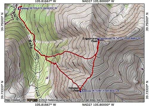
The Hike from Urad Mine.
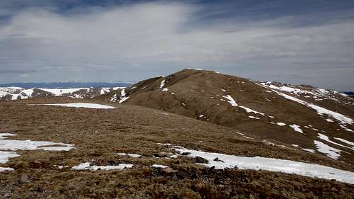
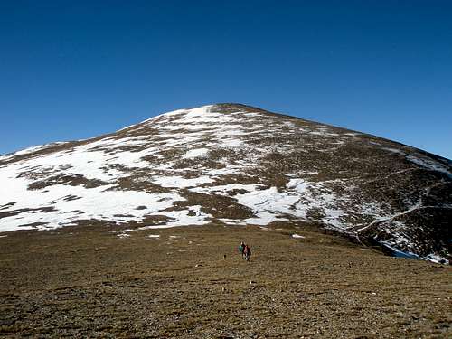
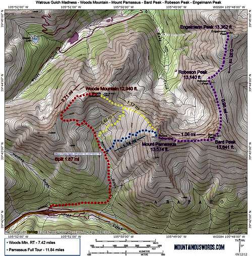 Robeson Peak from Herman Gulch
Red Tape
Clear Creek Tourism Bureau
PO Box 100, Idaho Springs 80452
(303) 567-4660 or (866) 674-9237
Georgetown VisitorsCenter
1491 Argentine St, Georgetown 80444
(303) 569-2405
Idaho Springs Visitors Center
2060 Miner St, Idaho Springs 80452
(303) 567-4382
Clear Creek CountyFact Sheet
Location:
P.O. Box 100, Idaho Springs, CO 80452
Clear Creek CountyTourism Bureau
Phone: (303) 567-4660
Toll-Free: (866) 674-9237
office@clearcreekcounty.org
Information: www.clearcreekcounty.org
Description:
Clear Creek County is located just 20 miles west of Denver along the I-70 corridor and encompasses the communities of Idaho Springs, Dumont, Downieville,Lawson, Empire, Georgetown and Silver Plume.
This mountain gem is where the historic west meets new adventure. Here is where the first gold strike took place. Visit working mine sand pan for gold; explore the historic Victorian mining towns of Georgetown, Idaho Springs, Silver Plume and Empire; or take a trip back in time on the historic Georgetown Loop Railroad®. Clear Creek County is also where you can get your adventure on! From hiking, biking, rafting,fishing, skiing and zip lining to scenic byways, 14,000-ft. peaks (14’ers), the highest paved road in the Americas and wildlife viewing, there’s something for every level of adventure.
You’ll also find unique lodging, dining and shopping experiences in a stunning mountain setting.
Historic Towns:
Created as a result of George Andrew Jackson’s discovery of gold on January 7, 1859, Clear Creek County is one of the original 17 designated state counties and one of the three counties in the state with its original boundaries still intact. In April 1859, groups of miners flocked to the area which was first known as Jackson’s Diggings, Sacramento City and Idahoe. In June of 1859, the area was formally organized, the first recorded in Colorado history. At that time, 400 people lived in the settlement. It later became known as Idaho Springs.
As more miners continued to move into the area, the prospecting moved west, following Clear Creek which runs most of the length of the county. Eventually the towns of Dumont, Downieville, Lawson, Empire, Georgetown and Silver Plume were established. In 1867, the Colorado Legislature called as pecial election and the county seat was moved from Idaho Springs to Georgetown. Today Clear Creek is a diverse destination where visitors can step back in time,wander the historic mining towns, explore museums and gold mines, and enjoy a wide range of outdoor activities.
Weather:
Weather in Clear Creek County is fairly moderate and can vary drastically depending on where you are. In summer, the day temperature ranges from 60-80 degrees with an average of 300 days of sunshine. In winter, the day temperature ranges from 20-45 degrees with an average snowfall ranging from 70 inches in lower lying areas to 400 inches at Loveland Ski Resort.
Seasons:
Summer: It’s high season in Colorado, which means it’s time to get outdoors and recreate! Clear Creek County is a virtual outdoor playground with a multitude of recreational opportunities as well as attractions.
Visitors can explore hundreds of hiking and biking trails;cast a line and fish; climb a 14,000-ft peak; ride the Georgetown Loop Railroad®, an authentic narrow gauge train that runs between Georgetown and Silver Plume; zip line across or raft Clear Creek; discover gold while panning at a real mine; explore historic mining towns; take in stunning views while driving along a national scenic byway; or simply camp out with the family!
Fall: When the aspens turn from green to shimmering gold it’s a great time for a hike, ATV ride or horseback ride in the mountains.Visitors can take in the fall foliage with a ride on the historic Georgetown Loop Railroad® or drive along a scenic byway. It’s also hunting season. Whether hunting with a rifle or bow visitors can search for big game such as elk, deer and small games such as turkey, Ptarmigan and Grouse.
Winter: As the snow begins to fall and blanket the Rocky Mountains, Colorado’s arid climate produces some of the world’s best powder for snow sports such as skiing,snowboarding, snowshoeing, snowmobiling, sledding, ice-fishing, ATVing, hot springs, and nature viewing.
Clear Creek County is home to one of the oldest ski areas in Colorado, Loveland Ski area and one of the newest, Echo Mountain. Visitors can experience all types of skiing (from downhill, and cross-country to snowboarding and telemark); explore high-country trails for snowmobiling,cross-country skiing, and snowshoeing; ice-fish on Georgetown Lake or simply relax in the hot springs at Indian Hot Springs.