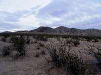
Overview
The Rough and Ready Hills are a set of volcanic hills west of Las Cruces, NM just south of the larger Sierra De Las Uvas mountains which are also volcanic. To the south of the Rough and Ready Hills lies the Potrillo volcanic field. These hills have started to become popular for rock climbing. This is not a remote area, but it is further away from Las Cruces than the popular Organ Mountains so it doesn't receive too many visitors. This area only started to become developed for rock climbing in 2000 by students from New Mexico State University. The difficulty of routes ranges from a 5.7 to a 5.12a. Even if you are not a rock climber you can still enjoy climbing this mountain. The western side of the mountain is a fairly gentle and short slope to the top and no rock climbing is required. The high point of the hills has a prominence of 672 feet. Because of its low elevation and low prominence it is not a popular spot to go hiking. Although climbing it can provide a beautiful view of the Organ and Franklin mountains to the east.
![Rough and Ready Hills]()
Getting There
From Las Cruces, take I-10 west. Take the airport exit and get on the frontage road. Turn into the entrance of the Corallitos ranch at county road 9. Follow this road for a while. You will pass the ranch and later pass an observatory. From here if you want to climb the easy slopes you can just find a place to pull over and off trail it to the top. If you want to head to the cliffs keep going until you see some gravel pits off to the right. There is a dirt road that leads past these gravel pits and ends in a parking lot. There is a trail from here.
Red Tape
None, but these hills are on the Corralitos ranch so respect their property.
Hiking
The only hiking trails in the area are short trails that lead to the base of the cliffs for the rock climbers. If you want to climb to the highpoint of the hills you will have to do some bushwacking. Bushwacking in this area is very easy because of the small amount of vegetation. The road that passes by these hills passes fairly close to the mountains so it is not a very long approach to the mountain. These hills do have some bee hives in them so watch out. Although the bees won't bother you unless you get too close to their hive. Once on top of the hills, you will have a great view of the Organ and Franklin mountains to the east, the Sierra De Las Uvas mountains to the north and the Potrillo mountains to the south.
Climbing
This relatively new climbing area has over 20 routes. They range from 5.7-5.12a in difficulty. The length of the routes ranges from 30ft to 100ft. Since these hills are volcanic they can be sharp and brittle in some areas. Overall the rock face is pretty solid though. The northern routes are exposed to the wind. On windy days some of the routes can be quite a challenge.
Camping
There are no campsites in the area.
External Links
Climbing routes
