Approach
Start from Mosquito Flat trailhead, follow trail toward Morgan Pass for about 4 miles. After passing Long Lake and before descending to Gem Lakes, ascend the slabs on the right to the top of ridge, then follow it southward until you see Treasure Lakes on the other side of the ridge. Descend the ridge to reach the four lakes.
Route Description
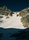
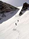
Ascend the ridge between the two southern Treasure Lakes over steep talus southward. This leads to the bowl directly below the Hourglass Couloir. The Hourglass is usually covered with snow, or ice in late season. The couloir is about 1000 feet high and steepens to about 40 degrees. In early season this is a straight-forward climb, but in late summer you either have to climb ice, or choose the small chute to the right of the Hourglass, which is steeper and contains much loose rock. In late summer the parts of Hourglass not covered by ice contain very loose scree. Once above the couloir, it is an easy ascent over moderate angle slabs for another 1000 feet.
Essential Gear
Ice axe is required in any season. Crampons may be needed depending on snow/ice conditions.
Miscellaneous Info
If you have information about this route that doesn't pertain to any of the other sections, please add it here.


yocal420 - Nov 15, 2005 1:19 pm - Hasn't voted
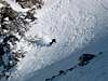
Route CommentThe couloir is an easy fun ski back to the lake. Many other lines in the area! Excellent spring ski spot!!