
|
|
Route |
|---|---|
|
|
44.16080°N / 71.6444°W |
|
|
Hiking |
|
|
Most of a day |
|
|
Class 1 |
|
|
Approach
 |
The Franconia Ridge Traverse is one of the most popular higher summit loops in the White Mountains. It traverses the two popular 5000 footers of Mount Lincoln and Mount Lafayette and one sub peak, Little Haystack. Most of this route is officially Class 1 and very well defined. However there are some short mini-scrambles on this route in which some would classify as Class 2. The traverse on the higher elevations of Mount Lincoln and Lafayette is totally above timberline and is on a narrow ridge. Some hikers would classify this as a knife edge but though it is narrow there is easy footing and one would have to be careless to fall very far from this ridge.
This is not the place to be hiking when bad weather is around. Due to the high elevation and the open summits, winds here can exceed 60 miles per hour and temperature can be dramatically lower than the the valley floor. Though this peak is very doable in winter proper gear must be worn or one can be at high risk very easily. Most fatalities that have happened on this traverse has happened because of hypothemia. In summer during thunderstorm this traverse can also be dangerous due it being so high on the ridge. If bad weather is in the area it is best to choose another destination.
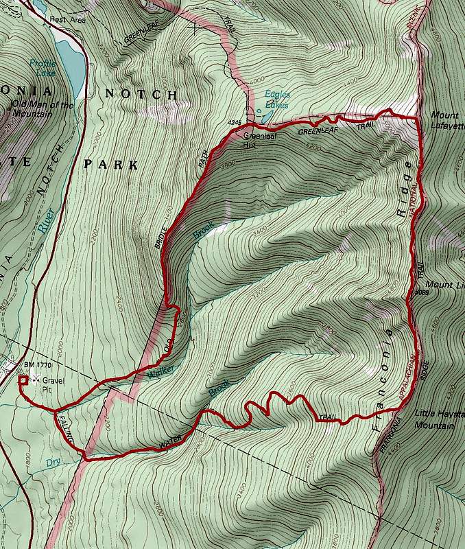
Map of the Route
 |
Route Description
FRANCONIA RIDGE TRAVERSE: 8.9 milesFALLING WATERS TRAIL (3.2 MILES)
FRANCONIA RIDGE TRAIL (AT) (1.7 MILES)
GREENLEAF TRAIL (1.1 MILES)
OLD BRIDLE PATH (2.9 MILES)
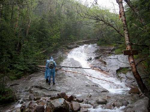
From the Lafayette Place Trailhead. Takes the clearly marked trail-way east of the parking lots for 0.2 miles until you hit junction where the Old Bridle Path is on your left and Falling Waters is on your right. Take the Fallings Waters Trail that immediately crosses Walker Brook. At 0.7 it crosses Dry Brook (2000') and then begins it climb up the brook. From there the trail will begins it at times steep climb up the side of Dry Brook, where it crosses very beautiful successive falls from lower to higher elevation: Stairs Falls, Swiftwater Falls (60 feet), and Cloudland Falls. It crisscrosses the stream several times until the highest crossing of Dry Brook at 1.6 miles (2860').
From here it angle uphill on an old logging road. It takes the road to a series of steeper switchbacks. It continues up the switchbacks until the last switchback, where there is a side path to Shining Rock (4,130 ft.) at 2.8 miles. Shining Rock has incredible views, but do not attempt to climb it without rock climbing gear. From here it is a a steep but straight line to the Franconia Ridge Trail (3.2 miles) (4760').
 |  |
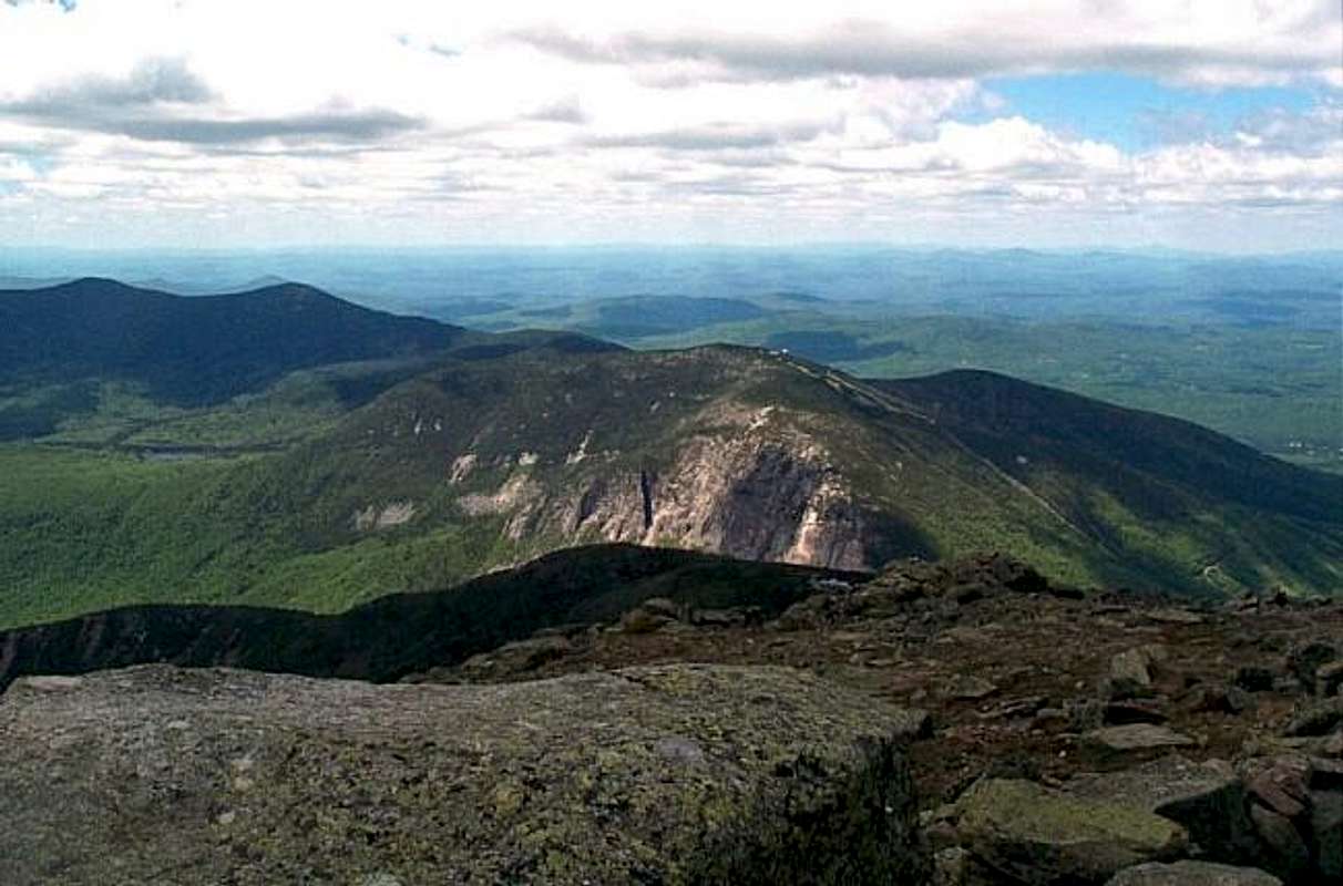
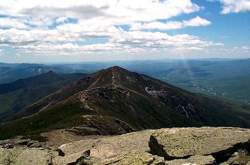
Take a left on the Franconia Ridge Trail as it ascends steeply to the summit of Little Haystack. Here is you will get your first taste of panorama view, and where you will first be above treeline. Off to the north is Mt. Lincoln while to the west is Mt. Mooselauke, Franconia Notch, The Kinsmans and Cannon Mtn. while to the east is Mt. Washington and the Presidentials in the distance with the The Bonds, Twins, Owl Heads and the rest of the Pemigwasset Wilderness in the background. From here continue the level hike along the knife edge ridge (not like Kathadin though) up to the base of Mt. Lincoln where the trail becomes steep until the summit. When up at the top of Mt. Lincoln (5089') take a short break and enjoy the views. Some argue that these are the best views on Franconia Ridge, while others argue that Mt. Lafayette as the best while others yet believe that North Lafayette has the best views. You be the judge.
 Mount Lincoln from Little Haystack Mount Lincoln from Little Haystack | 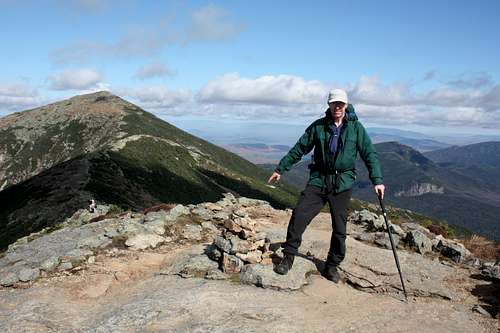 Looking towards Lafayette Looking towards Lafayette |
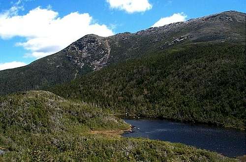
The trail then descends another sag, climb a large hump then descends another sag to a scrub patch where it then climbs a moderate up to the top of Mt. Lafayette (5260'). On top of Mt. Lafayette enjoy the beautiful views that surround you. The view of the rest of Franconia Ridge to the south is among the most popular view all of the Eastern United States Mountains. The view, north, east or west are world class as well.
 The Classic Lafayette View The Classic Lafayette View |  Another splendid view from the ridge Another splendid view from the ridge |
Take the Greenleaf Trail down to Greenleaf Hut (4220'). At point 0.2 miles down the trail you will come up on a spring near a ledge. The trail continues to drop at a moderate grade until scrubby grow 0.5 miles from Mt. Lafayette. At 0.6 miles from Mt. Lafayette there is an open sandy area with extremely good views of Mt. Lincoln. The trail then descends to the beautiful Eagle Lake then rises a short hump to the Greenleaf Hut where great views of Mt. Lafayette are all around.
 From Greenleaf Hut From Greenleaf Hut |  Another spendid view from the ridge Another spendid view from the ridge |
Then takes the Old Bridle Path which will be on your left. 0.5 miles down the trail you hit a side path which leads to some very good views. The trail then descends Agony Ridge. Though not as steep as some sections on the Falling Waters this part of the trail can give you problems if you carrying heavy loads. About 1.0 from Greenleaf Hut you hit a number of beautiful views of Walker Ravine and Franconia Ridge. At 1.3 miles it leaves the ridge on rock steps and lowers elevation at a moderate grade where the Franconia Notch State Park sign can be seen at 1.8 miles. The Old Bridle Path than it hits the Falling Waters Trail junction at 2.7 miles and heads back into the parking lot.
Essential Gear
In wintertime and early spring crampons and full winter gear are a requirement due to a number of slippery areas along each side of the loop hike. The Falling Waters Trail is especially difficult without crampons in winter. An Ice Axe would be requires in winter. Bring snowshoes and keep an eye on the avalanche forecast if there has been a lot of recent snow!In summer and fall taking this hike doesn't any special gear except hiking boots, and essential hikng gear. However weather like on Mt. Washington can change very rapidly especially in fall, so keep an eye on the weather can dress accordingly. Do not climb this or an of the other high peaks in April or May due to the fact that it is mud season and the trail can become easily eroded at this time. June is a good time to climb, but bring the strongest bug repellent known to man. It is black fly season.
One major item you will need is camera and LOTS OF FILM. I can't tell you how many photo contest have been won from photographers who have climbed Franconia Ridge.