
|
|
Route |
|---|---|
|
|
42.70740°N / 0.03210°E |
|
|
Scramble |
|
|
A long day |
|
|
Grade I UIAA |
|
|
Approach
Start from the spanish valley of Pineta, 11 km west of the village of Bielsa. In order to get there you'll need to drive in from Huesca.Follow road signs from this city to Barbastro (road N-240). After this town, follow road number N-123 (direction Graus) and turn left on road C-138 to El Grado and Aínsa. When you reach this last village do not leave that road, follow north the signs to Bielsa or Francia. After 33 km, in Bielsa you can find the crossroads to turn left and reach the Parador Nacional de Pineta (National Hotel) in 11 more km.BUS ACCESS: The bus company Hudebus serves the line from Sabiñánigo to Aínsa and back (including stops at Torla and Broto, the villages placed closest to the Park). Phone number 974213277 (in Huesca).The Bielsa web page tells about bus connections between Aínsa and Bielsa at 21.00 h (daily in summer, monday-wednesday-friday the rest of the year) and Bielsa-Aínsa at 06.00 h (same yearly schedule).
Route Description
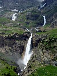 The waterfalls of the Cinca.
After the crossing, the path continues to the left. Turns right once more to go over a rocky balcony and a new cliff. At this point we shall find ourselves in a couloir (2320 m, 3h walk) where the path climbs W / SW turning once and again to reach the entrance to Balcón de Pineta (2500 m, 3h 30'). This couloir is the riskiest point of the whole route in winter time, about 30º-35º and particularly exposed to avalanches.
Just after entering the Balcón de Pineta you will find the iron memorial cross of Grávalos
 Entering the Balcón de Pineta
 The sight of Gran Astazú from the area around the Lago Helado de Marboré
Essential Gear
No special needs in summer season. For winter climbs full equipment is mandatory, including avalanche detectors. The final climb before you get to the Balcón de Pineta is specially prone to avalanches.National Park Regulations
As reported by Diego Sahagún and incorporated in the SP page of Monte Perdido, these are the Regulations of the Spanish National Park of Ordesa and Monte Perdido (which covers the whole climbing route of Gran Astazú from Pineta):The National Park Regulations, as apported to this page by Diego Sahagún are the following:
PRUG (Real Decreto 409/1995):
- Free camping is forbidden. It's permited to vivy or camp using a tent lower than 1.3 m/ 4 ft 3.25 in, wich would be taken down at dawn. This practice is allowed above these heights:
Ordesa area: 2.100 m (Clavijas de Soaso)
Añisclo area: 1.800 m (Fuen Blanca)
Escuaín area: 1.800 m (La Ralla)
Pineta area: 2.500 m (Balcón de Pineta / Bolán de Marmorés)
- Sports aside hiking, climbing, mountain skiing and speleology are forbidden.
- The sale of commercial products is not allowed
- It's forbidden to swim in the rivers, streams and lakes