
-
 8320 Hits
-
 74.01% Score
-
 4 Votes
|
|
Route |
|---|---|
|
|
42.83890°N / 0.2903°W |
|
|
Download GPX » View Route on Map |
|
|
Scramble |
|
|
Half a day |
|
|
F |
|
|
Approach
Trailhead: Mountain Hut of Respomuso (2130m) or Dam of La Sarra (1440m).The approach to Respomuso from Dam of La Sarra: 2h 40min. In the middle is the bifurcation to Lakes of Arriel.
See my route in Respomuso-Picos del Infierno for complete information.
There is another possible approach from the french side (refuge de Larribet and cirque de Batcrabère). This route goes to the col Noir and from there is the same route across the gran diagonal.
 |  |  |  |  |
Route Description
Slope: 1720m or 1014m (from Respomuso)Time to summit: 5h from Respomuso, 5h 30 min from La Sarra.
Face: west ridge.
From Respomuso (2130m) go to the west following the mark of GR bordering the dam. After the dam the way go in the top part of the ravine of river Aguas Limpias and for a path in the hillside we reach the first lake of Arriel.
From La Sarra an important turn aside to whom there will be necessary to be very attentive in that a plate in the wall will indicate towards the rigth side ibones de Arriel (left side 1h). The way is easy initially for a nice forest but soon we will appear in a channel of stones with hard slope, it is barranco de Arriel (Arriel's ravine). We will follow the cairns (and marks of red paint) and in the middle part we will see the marks that take to us towards the right (east) for a narrow path in the hillside.
Important: you must be carefull for take the route of red marks out of the path in the middle of ravine (if you go seeing the path in the ground you don't look the desviation and you must turn back from the top of the ravine).
We will come this way to the Arriel's first lake to 2170m.
After leaving the second lake to the right we will avoid the climb towards Arriel's top lake. You must to follow the path what it border the lake for below and the right. After the final of the lake we will look towards the right the corridor (cairns) for the way that leads to Arriel's frozen lake (2405m) for a hard slope on free rock with drafts towards the left side.
The lake is bordering for the north (left side) to the cirque of Brecha Latour. For a rock spur we will come to the refuge or vivac of Michaud (free, 6 places) at 2700m.
Important: the cave of Michaud it's the key to the entry in Gran Diagonal and it's under a great rock. You must follow the cairns that go to the refuge with a little desviation to the right before the turn to the left side.
We leave the hill towards the left side for one channel and in zig-zag for the hillside we will come to a slightly visible gap.
Very important: to find this point is easiest if we go to the left side but can go out towards the right to a ridge of degree III (the ridge Packe-Russell). If you don't see the cairns and you don't descent a bit of meters you're wrong. The diagonal it's visible in this point in the left side for a good orientation.
After a small decrease we appear in the Gran Diagonal (Great Diagonal) that we will continue mending almost until the end in Isards's gap (if we leave the gap behind and we come to the end is sufficient in spite of going a bit back).
Now we have to climb over a concave wall (grade I) to the right and finally for the north buttress it takes us to the summit (3151m).
Final important consideration: many people don't find the channel (concave wall) in the first attempt but you must turn back if you find some difficulty. The final channel it's white rock and it's a easy climb (if you find steps of grade II or vertical walls, you're in the Brecha d'Isards, don't try the climb for this dangerous point!). The begin of the chanel it's in the middle of a little path signaled with two great cairns in one side.
 |  |  |  |  |
Gran Diagonal
The great diagonal is a very spectacular itinerary hung on the impressive north-west face of the Balaitous. Nobody must try this itinerary with snow or ice (it is to have desire of committing suicide).It is curious that is very difficult to find photos in books or Internet of the diagonal and it's important to know that it is a simple itinerary though it is very exposed. The persons who do not know it can to return on having seen the first view of the diagonal hung on the immense wall.
 |  |  |  |  |
Pictures of Lakes of Arriel
The lakes (or ibones) de Arriel are one of the nice places of the zone and many people make a hike to this not for mountaineering. For the mountaineers are a valious point of orientation of the routes (and for enjoy the view of course)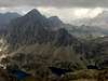 |  | 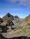 |  |  |
Essential Gear
In winter crampons, ice-axe, harness and rope though this route it's not advisable for this mount in winter because the Gran Diagonal with snow is dangerous (diagonal itinerary with 30º or 40º, exposed).No requeriments generally in summer but the helmet is advisable in the last climb for the dangerous stones that it falling here.
 |  |
edouet - Apr 20, 2006 6:58 pm - Hasn't voted
Col Noir RouteTrail Head: from the Village of Arrens-Marsous, follow the road leading to " Plan d'Aste - Parc National des Pyrenees "( avoid the road leading to " Lac d'Estaing " ). Park beside the small house " Maison du Parc National " - 1470m - Route: Cross the Gave d'Arrens on a footbridge, and head south on a good trail. After the Lac de Suyen, head to the right ( South/South-East ), crossing the stream and hiking up towards the " Refuge de Larribet / Larribet Hut ". The path is well-marked with yellow post signs and cairns. Refuge de Larribet: - 2060m -, 2 hours from the trailhead. Hike up to the Breche de Garenere / Garener Breach, to the SouthWest. From the Breach, go down to get above the Lacs de Batcrabere / Batcraber Lakes. Follow the path to the SouthWest, than to the South, from the last Lake ( Lac Inferieur du Micoulaou ). No path anymore, only cairns. Reaching the foot of the Col Noir ( Black Pass ), you have to choose: either get crampoons and climb in snow and ice, either climb the screes and rocks on the right ( a bit tricky, not for beginners ). Once at the top of the Col, climb down 50m to get the path coming from the Lacs d'Arriel and leading to the Grande Diagonale.
Rafa Bartolome - Apr 24, 2006 6:37 am - Hasn't voted
Re: Col Noir Routeedouet, you can to add this information as new route, I think is better.
edouet - Apr 24, 2006 3:13 pm - Hasn't voted
Col Noir and Neouvielle.Ok, Rafa. Tengo unas fotos del Neouvielle/Pic Long: pienso que seria interesante anadir este grupo en SP. Pienso que tu y Eza teneis tambien documentos ( itinerarios, fotos ... ). Te gustaria hacerlo?
Rafa Bartolome - Apr 24, 2006 6:34 pm - Hasn't voted
Re: Col Noir and Neouvielle.Yo no he estado nunca y no tengo ninguna foto, tengo mucha información en libros y mapas sobre itinerarios a Neouvielle pero no me gusta mucho hacer páginas de montañas que no he subido en persona... pero si no te ves capacitado para hacer la página podría escribirla y tú pones las fotos, aunque sería preferible que la escribieseis tú si puedes.