
-
 16105 Hits
-
 0% Score
-
 0 Votes
|
|
Route |
|---|---|
|
|
38.85690°N / 119.9002°W |
|
|
Hike |
|
|
Half a day |
|
|
Walk Up |
|
|
Approach
From the Luther Pass sign south of Lake Tahoe on Hwy 89 go south 0.8 miles until you see a paved left turn. Turn left, the pavement ends abruptly and turns into a dirt road which may require a high clearance vehicle. Travel about 3.4 miles until you cross the second bridge and park on the left near the unmarked trailhead. The trail head crosses a new bridge back over the last stream crossing.
Route Description
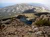
From the unmarked trailhead, travel west on an old road following it to the end. There is a junction to the left which you ignore. At the end of the road the single track trail starts and climbs up to Armstrong Pass. It is 1 mile and a few hundred feet of elevation gain. At the top you will hit the Tahoe Rim Trail with a sign to the left showing Big Meadow 9 miles, and to the right showing Star Lake 5 miles. Take the trail to the right and climb 3 miles and a 1000 feet or so to the saddle between Freel and Fountain Place. At the saddle you see Lake Tahoe for the first time. A sign warns to protect the rare Tahoe Draba by staying on the trail. A newly constructed trail now leads 1 mile and 1000 feet of elevation gain to the summit, it is not quite finished near the top. The radio tower at the top is now gone. There are good views all around since this is the highest peak in the Tahoe area.
Job's sister and Job are now obvious choices. Since it will take only 2 hours or so to get back down. We elected to take the visible use trail to Job's sister. Then traverse the ridge line down to Star Lake thus avoiding the Draba restriction area. Swimming in the lake can be a cold but refreshing experience. From the west end of the lake the TRT ascends back up to the saddle and back to Armstrong Pass. This section is strewn with white quartz rocks that abound the area.
Essential Gear
None
Miscellaneous Info
If you have information about this route that doesn't pertain to any of the other sections, please add it here.
 |  |