
|
|
Route |
|---|---|
|
|
36.70770°N / 117.9621°W |
|
|
hike |
|
|
Half a day |
|
|
class 2 |
|
|
Approach
From the parking area, head up the wash towards the ridge seen on the south side of the wash (located at about the 5700 ft countour.) A trail is visible ascending from a register box at the foot of the ridge and going up into the distance.
Route Description
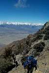
Start heading up the steep, obvious use trail. A much harder alternative is to continue another 1/4 mile up the wash and ascend the scree slopes on the north side of the ridge, following ocassional cairns. Unless you are looking for a massive cardio workout, this route is not recommended. This route eventually merges with the ridge route once the top of the ridge is met.
Continue up the ridge, following the well defined use trail. It will switch back from time to time but remains steep most of the way until just before you reach Bedsprings Camp: 7075ft 36.71743 N x 117.99935 W
Here you will find the remains of an old mining camp replete with an ancient rusty set of bedsprings. There are about a half dozen nice flat campspots to be found here.
From the camp, continue heading east for about 1.25 miles to the obvious large col between Inyo and Keynot. Keynot Peak summit lies another 2+ miles south and can be acheived most easily by traversing low on the westerly slope following cairns. The summit is easily discerned by the "diving board" rocks looking westward.
 |  |
Essential Gear
No technical gear is required to surmount this peak. Plenty of water, trekking poles and above all else, stamina will make the ascent less ardous. If you plan on doing this while snow is still visible up high, an ice axe would make the traveling a bit more secure
Miscellaneous Info
If you have information about this route that doesn't pertain to any of the other sections, please add it here.