
|
|
Route |
|---|---|
|
|
40.31880°N / 105.6941°W |
|
|
Trad Rock Climb |
|
|
Most of a day |
|
|
5.6 (YDS) |
|
|
5 |
|
|
III |
|
|
Overview
The Spiral Route on Notchtop is one of the classic alpine moderates in Rocky Mountain National Park. It boasts a modest rating of "5.4" and manages to find a relatively easy way up the imposing face by spiraling up and around the tower. Although having a reputation for being easy, the Spiral Route should not be taken lightly. Many climbers get lured off-route onto more difficult terrain, and the crux moves are commonly closer to 5.6 than 5.4. This is also a committing route and escape is not easy. In his RMNP Guide, Gerry Roach states...
"This classic route has been titillating climbers for years. It is well named as it spirals completely around the peak to reach the summit. This is a steep and committing route. Retreat can be difficult, and the exposure is often severe. ... There is a lot of grass on the route, and after a summer hailstorm it becomes murderously slippery in slick-soled rock shoes."
That said, if approached with clear weather and the proper skills, this is a fabulous route to one of the least accessible and impressive summits in the park.
 The Route
Approach
Start from the Bear Lake parking lot and make your way up the Flattop trail. After about a mile, take the junction onto the Fern-Odessa Lake trail. Mosey along the nice trail as it contours alongside the slopes of Flattop and look out for the sign marking the Sourdough backcountry campsite. Shortly after the sign for Sourdough, there will be a small trail that leaves the main trail and heads down past Two Rivers Lake and then to Lake Helene.Skirt the lake on the right and head up the vague rib that goes to the rocky bench below Notchtop.
A faint "trail" leads up towards Notchtop and leads into the gully on the western (left) side of the spire. Ascend it for about 200 vertical feet and keep your eyes peeled for a faint ledge system that leads back left to a ledge on the ridgeline (see photo). Some climbers miss this and end up climbing too high. Rope up on the large ledge and get ready for business.
If you descend the gully like most folks do, you will pass by this spot on the way down.
 Rough map on where to go.
 Notchtop coming into view from the Odessa Lake Trail.
 Notchtop viewed from above Lake Helena. The path from here skirts the tower on the left and ascends a talus gully for 200 feet.
 This is the crucial turn in the gully that leads you to the ledge that begins the route. It would be easy to miss this so look sharp.
 Looking up the base of the route.
Route Description
There are several different ways to do this route and routefinding is important. If you feel like you're on harder terrain, look for an easier way. Here is a basic overview starting from the large ledge...
Ascend 3-4 short pitches of 5.4 enjoyable rock moving up just right of the nose of the South Ridge. There are several broad ledges with good natural horn anchors on each ledge. On the 4th ledge, you'll be below a vertical section of the South Ridge and upward progress is possible, but it is the South Ridge route and rated much harder than the Spiral Route. Now traverse right about 100 yards. You will pass a flaking outcropping and be below the grassy "meadow" that leads up toward the famous notch. Multiple options exist from here and many are harder than 5.4 so choose carefully. The easiest path leads up the grassy ledges on the left side of the meadow. If it feels too hard it is very possible you are off-route. There are about 2 short and one long pitches from the ledge to the notch and the grass and dirt on this section are annoying and potentially dangerous in wet weather. Once in the notch, drop anything you don't need to get to the summit. It is only 4th class from here to the top but it is highly exposed and many parties would still want the security of a rope. Drop over onto the western side of the notch and make your way up a broad rocky ledge above the sheer western face. Make your way carefully across and then back toward the summit via a thin 4th class traverse. The final ridgeline is easy and summit comes as a wonderful surprise. Sit back and enjoy this tiny summit!
 Starting P1.
 Looking down P2.
 Heading across the large ledge that traverses into the hanging meadow.
 Looking up into the hanging meadow and the notch. Multiple options exist here.
 The rocky ramp leading up to the summit from behind the notch.
 The final 4th class moves before the summit.
Descent
The descent from the summit is an exposed 4th class affair that should not be underestimated. It is possible to rappel the steep western face but is requires 2 60M ropes and is complicated so I will no describe it here. Go back to the notch, grab your stuff and climb up the easy ramp (3rd class) north that leads to the true summit of Notchtop. Make your way along the ridge for a short distance and look sharp for a small cairn that leads off to the left onto the western side. The route follows a faint weakness in the cliff and traverses across the exposed face. This is 4th class but a slip would be your last. Discuss whether a rope is appropriate for your party or not and continue forward. You will eventually reach a saddle at the top of the gully that you climbed partway up earlier. Scramble down the West Gully to where the Spiral Route started, grab anything you left and head out.
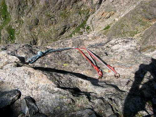 Rappel slings on the rocky ledge. You can make several DOUBLE rope rappels but it is complicated.
 The ledge system that you must traverse.
 Exposed moves on the descent.
Essential Gear
Gear needed could vary dramatically depending on your comfort level. Here is a suggested list assuming you want full climbing gear and you can trim it down to fit your needs.
Gear: Full rack - Set of stoppers, set of cams (C4s 0.5-3 with doubles of 0.5-2), TCUs 1-4, 60M climbing rope (pitches might be combined with a longer rope), 12 double-length runners to reduce rope drag.
Miscellaneous Info
Other good route descriptions: Climbing Life, Mountain Project
Weather Forecasting: NOAA, Weather.com, Climbing Life
RMNP Info: Backcountry Camping, Park Website