
|
|
Route |
|---|---|
|
|
40.26830°N / 105.6497°W |
|
|
Scrambling |
|
|
Most of a day |
|
|
Class 3 |
|
|
Approach
From the Glacier Gorge Trailhead at 9,180 ft, follow the directions for Black Lake (10,620 ft). (See the Sharkstooth page for a description of a genuine shortcut.) The trail reaches the northeast corner of Black Lake. From there, cross the outlet stream on logs and bushwhack along the edge of the lake following faint trails. Gain elevation through the trees in the northwest direction and finally traverse west on ledges to reach the base of the summit tower of Arrowhead. If you pick your route carefully, you can avoid krummholz and the slabs will need only a few Class 3 moves.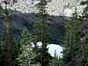 |
Route Description
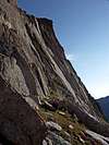
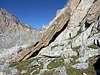
From the base of the south face, more or less under the summit tower, gain the so-called access ramp, which is a large ledge rising from right to left as it approaches the deep gully to the left (west) of the summit. The yellow line in the picture gives a possible route, but there are many options that only require the occasional Class 3 move. The beginning of the access ramp is marked by cairns and is difficult to miss in any case. Once on the access ramp there is only one way to keep the difficulties at Class 3: it is marked in red in the figure. Go up the ramp until you reach a leaning rock. You can pass under it or go around; the latter is easy but exposed. Immediately thereafter a cairn marks the point where you turn right and up.The easiest passage is immediately around the corner to the left of the pillar you see in front of you. The exposure is considerable--the view suddenly opens up on the deep gully coming down from the summit--but there is abundance of holds. As soon as the angle of the pillar relents, move right and scramble to the beginning of the summit ramp. The stretch connecting the two ramps is Class 3. Follow the easy ramp as it spirals counterclockwise to the summit.
You can descend by retracing your steps; the cairns may be useful to remember the major turns in the route, especially when to descend from the summit ramp to the access ramp, and when to leave the latter to head down. Another possibility is to descend the Northwest Face. Good routefinding ability is required for this option. You can also continue to McHenrys Peak by climbing the Northeast Arête.
The Summit Ramp provides the easiest way to reach the summit of the Arrowhead. It is a fantastic route for its level of difficulty: looking at the south face of the Arrowhead few would think that 100 feet of Class 3 are enough to get to the top. It is certainly not a route for unaccompanied beginners, but the experienced hiker will find it a rare treat.
 |  |  |  |
MurphyJ - Aug 29, 2009 4:52 pm - Hasn't voted
Don't Underestimate Getting Onto The "Access Ramp"Kudos to Brenta for his great route description. But climbers should be aware that getting onto the Access Ramp is not as easy as he makes it sound. A friend and I hiked up there on 8/26/09 and spent over an hour looking for an easy way onto the Access Ramp. Brenta says that "there are many options that only require the occasional Class 3 move". We did not find this to be true. The easiest way I found onto the Access Ramp involved about 50' of somewhat exposed Class 4 slab climbing. My friend is quite risk-averse these days (with 2 young kids) so we had to turn around because of this. JM
_alpha - Aug 24, 2015 12:28 pm - Hasn't voted
Start of Access RampClimbed 8/22/2015. I do not believe I directly found the cairn described for the "start of Access Ramp", though I did not have any particular difficulties. - There was a cairn marking a point that I considered the transition from the grassy slopes above the slabs from Black Lake to the point where I started traversing west below slabs looking for a spot to head upward. - Once moving up the slabs some and I had started traversing back climber's right I saw a cairn some 20' below me that may have been the cairn at the "start" described. In any event, I found generally easy and clear passage all the way to the leaning rock.