-
 18776 Hits
-
 82.48% Score
-
 15 Votes
|
|
Route |
|---|---|
|
|
48.77700°N / 113.726°W |
|
|
Hike/Scramble |
|
|
Most of a day |
|
|
Not difficult, but some exposure |
|
|
Approach
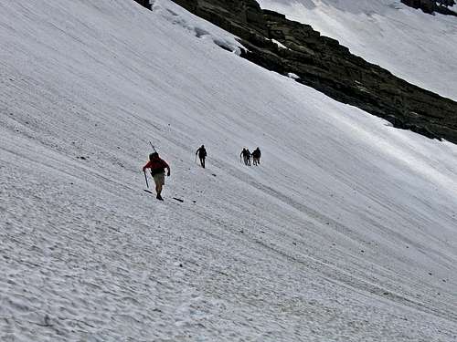
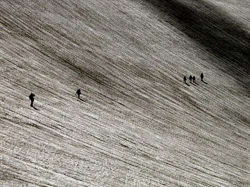
RETURN VIA SWIFTCURRENT GLACIER (not the Grinnell Glacier Overlook), THEN GRANITE PARK CHALET TO "THE LOOP." This trail head is exceptionally easy to locate. Simply take Going-to-the-Sun Road to The Loop, which is marked on all maps, and where there are both parking and restroom facilities. The Loop is approximately half way, mileage-wise, across GNP. If coming from West Glacier it is about 25 miles, and if coming from St. Mary—that is, from the east—it is about the same distance, but with the added incentive of crossing the Continental Divide at Logan Pass. The trail is well marked, and takes off at the immediate north end of the sharp turn comprising The Loop, is quite good until approximately a mile past the Granite Park Chalet—at which point, upon reaching the Grinnell Glacier Overlook it becomes a (good) goat trail. Net elevation gain from trail head is 4550', but substantial elevation is lost, then regained, so add approximately 1,000 feet of work. Round trip distance is slightly over 13 miles. Route Description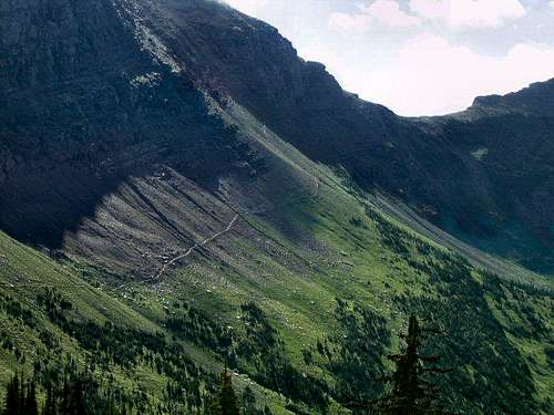 The Grinnell Glacier Overlook Trail, A Saintgrizzly photo The Grinnell Glacier Overlook Trail, A Saintgrizzly photoReaching the Grinnell Glacier Overlook: This route can be found in Volume 3 of Climb Glacier National Park. This is an updated book featuring full color photographs of routes and much more. Find it when you arrive in the area from local retailers or order it from the author on line at Volume Three. The approach is relatively straightforward. From The Loop take the very good, well-marked trail (appropriate signage marks the starting point) to the Granite Park Chalet, a distance of four miles and about 2,000 feet elevation gain. Approximately a hundred yards or so from the Chalet, the trail joins the Highline Trail, at which point follow the Highline Trail a short distance—maybe a quarter mile—as though you were going south, to Logan Pass. Soon, you'll come upon the trail taking off left, leading up to the Grinnell Glacier Overlook (see picture at right). The Grinnell Glacier Overlook trail can also be approached from Logan Pass via the Highline Trail which includes about 7 miles on easy trail and significantly less elevation change. A climbers trail from above the Weeping Wall near Haystack Butte can also be used to approach which further reduces the distance to about 4.5 miles. No matter how the Overlook Trail is approached the climb to the Overlook is a lung searing - tired leg taxing .6 miles of steep yet well-maintained trail. Upon reaching the overlook (stop and marvel at the view!) the human trail ends, but not to worry, the trail is not difficult). Before discussing the actual route a discussion of the route found in the Climber's Guidebook is needed. There appear to be two seperate route descriptions provided for Mount Grinnell, The Grinnell Glacier Overlook Route, in Gordon Edwards' A Climber's Guide To Glacier National Park, p. 192 - 193. Both of them are somewhat confusing and misleading. In the first portion of the route description on page 192 Edwards mentions a route that leaves the overlook and drops almost down to the Grinnell Glacier Trail. He writes about using an ice axe to cross very steep snow above the meltpond or a traverse through a scree field between upper and lower cliffs until reaching descending scree fields a little further north.  The views are incredible along the route!, a FlatheadNative photo The views are incredible along the route!, a FlatheadNative photo
Edwards also includes a second description from the overlook to the summit of Mount Grinnell that was published by a climber named Rolf Larson. This route is described as angling up the eastern slope towards the false summit (unnamed point 8479). The text describes climbing 500 feet through broken cliffs and then locating "two horizontal ledges across the great cliff face". Both ledges lead to a slope just below the lowest point of the saddle east of the false summit (8479) with 1,200 feet of exposure of exposure below. He continues that the saddle is reached after that tremendous exposure.
Off Trail Instructions: This portion of the route is contributed by FlatheadNative and Saintgrizzly: With all of that said here is a more succinct description, with photos.  The correct starting place for the route. FlatheadNative photo The correct starting place for the route. FlatheadNative photo Traversing across the scree field, a Saintgrizzly photo Traversing across the scree field, a Saintgrizzly photo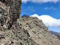 Walking below the cliff to the saddle, a Saintgrizzly photo Walking below the cliff to the saddle, a Saintgrizzly photo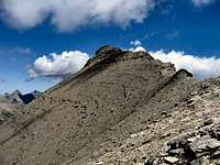 The summit ridge,a Saintgrizzly photo The summit ridge,a Saintgrizzly photoThere are NUMEROUS goat/human trails leaving from the Grinnell Glacier Overlook; for some reason people like to build cairns as well, and many if not most of them are misleading. Some "trails" extend to the south above Salamander Glacier, some extend to the north along the Continental Divide and others travel to the east side of the ridge below Point 8479. The entire key for this route is to locate the correct goat trail and to identify where the trail transitions to the scree field beyond the cliffs below Point 8479. There is a goat/human trail that traverses to the east that leads to the saddle west of Mount Grinnell. Here is how to find it: From the saddle work your way north gaining perhaps 30-40 feet and look for the rocky cliff that has a trail just above it. Follow this trail or this elevation contour BELOW the cliffs to the far side of the massive scree field below the cliffs. So basically you will have traversed across the east side of the ridge below the cliffs. You will have lost, not gained a slight bit of elevation to a low point, and then regained that elevation by staying just below the cliffs until reaching the point where Mount Grinnell first comes into view. From there continue on the trail across a talus field and finally below a great cliff that has a marvelous goat trail just below it. Follow that goat trail to the saddle between Point 8479 and Mount Grinnell. From then on it is basically a relatively simple matter of working your way to the summit. The final approach up this mountain is quite obvious, not at all difficult, and the views are truly spellbinding! Stay on or near the ridge for easier walking. The Return Route: Either retrace the entire route to the Grinnell Glacier Overlook or follow saintgrizzly's lead and explore the Swiftcurrent Glacier Basin. On the return we chose not to retrace our steps, but to cross the Swiftcurrent Glacier, which is in the basin immediately west of the mountain. Crampons were not needed (July 18th), but would probably be advised earlier in the summer, or definitely recommended if the surface is frozen; this is by no means a difficult or treacherous glacier crossing, and it is not necessary to rope together (crevasses are all considerably higher); however, the slope is just steep enough that each individual in the party will want to have an ice axe. Crossing the glacier helps to avoid a substantial elevation loss encountered by crossing the bottom of the basin below the ice.
Route Map
Essential GearIf crossing the Swiftcurrent Glacier via its lower portion on your descent (which is recommended, as doing so will save a great deal of elevation loss), an ice axe is needed; if the surface is frozen crampons would also be required. Ropes are not necessary, as there are no crevasses where you will be crossing.
In TributeOn March 1, 2011, Vernon Garner, Saintgrizzly, left us after losing a bold, inspiring fight against pancreatic cancer. Or maybe he won, for he is at last free of his pain and has "shuffle[d] off this mortal coil."Vernon was an important contributor on SummitPost, but beyond merely making good, informative pages, he actually inspired many who read his work. No one put more work into his or her pages than Vernon did, and many of those pages, especially those related to Glacier National Park, the place he loved above all others, are works of art in both the writing and layout. More than one person has wanted to visit Glacier or go back to Glacier largely due to what he shared about that magnificent place. Many people on SP counted Vernon among their friends, and many more saw him as one of the best, one of those who exemplified the spirit of this site. He was one of the best of us, he will be missed, and he will not be forgotten. As a tribute to him, Vernon's pages will remain in his name. Any member who sees a need for an addition or correction should please contact site management via the "Send PM to the Elves" feature. Rest well and climb on, Vernon. |