
-
 24294 Hits
-
 74.01% Score
-
 4 Votes
|
|
Route |
|---|---|
|
|
37.57770°N / 105.48590°E |
|
|
Mountaineering, Trad Climbing, Scrambling |
|
|
Summer |
|
|
Most of a day |
|
|
5.0 (YDS) |
|
|
III |
|
|
Overview
Gash Ridge is the aesthetic east ridge of Blanca Peak. It was first climbed by either Enos A. Mills during or before 1911 (1) or by Carl Blaurock & Mary Cronin in 1937 during Labor Day weekend (2). Gash Ridge is less prone to rockfall than the North Face. Blanca Peak's Gash Ridge from Huerfano Valley
 Blanca Peak's Gash Ridge from the East
Getting There
From Gardner, CO, head west on 69 to a well-signed turn off for Redwing. Just after making the left, you'll notice a sign indicating Lily Lake Trailhead. Travel 6.9 miles. Continue straight for 4.4 miles. Go left onto Huerfano Road for 5.9 miles to the Lily Lake Trailhead. Dawson considers this road high-clearance two wheel drive (3). Roach considers the last 100 yards four wheel drive (4). I agree most with Dawson. Follow the Lily Lake trailhead to the first sign for Lily Lake. The sign indicates Lily Lake is to the right. Follow it. At the second sign for Lily Lake indicating a right, go left and follow Huerfano River to the base of Blanca Peak's north face. Camp just below treeline if you choose. Blanca Peak's Gash Ridge Route
Route Description
Continue up a drainage east of unlabeled Point 13,360, then continue west up to its summit (red). Some choose to scramble directly up its north ridge (blue). From Point 13,360, follow the ridge to Blanca's summit.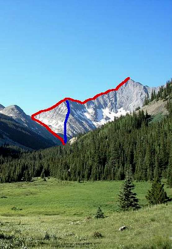 Blanca Peak's Gash Ridge Route Variations
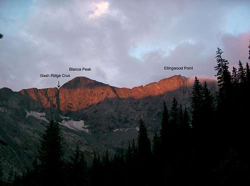 Gash Ridge's Crux
Roundtrip Distance: 9 miles
Elevation Gain: 3,665'
Essential Gear
Climbing gear or free solo ability.External Links
http://www.mountainweb.com/mountain-climbing/colorado-14ers/view-mountain-route.jsp?id=44&peak_name=Blanca%20Peakhttp://14ers.com/php14ers/tripreport.php?trip=3230&np=49&cpgm=tripmain
References
1. The Spell of the Rockies, Pages 107-19.2. Roof of the Rockies Third Edition, Pages 115-6.
3. Dawson's Guide to Colorado's Fourteeners, Volume 2, the Southern Peaks
4. Colorado's Fourteeners: From Hikes to Climbs Second Edition