
|
|
Route |
|---|---|
|
|
51.32528°N / 115.22111°W |
|
|
Ice Climbing |
|
|
Winter |
|
|
Less than two hours |
|
|
WI 4-5+ |
|
|
1 |
|
|
II |
|
|
Overview
The GBU (The Good, The Bad and The Ugly) is some of the closest ice climbing to Calgary, with the shortest approach. This makes it ideal for a lazy afternoon in the sun with low commitment.Getting There
 The GBU
You need to keep following this road until the first significant open water river crossing. There are kilometer markers on this road as of 2007, and this creek crossing is at marker #39. At the time of writing, this is where you need to park - it is illegal to go past this point. Check the local conditions to find out the status of this road. If it is open, with a high clearance 4x4 one can drive up to the base of the climb.
From this parking spot, you need to cross the river and walk upstream for about 10 minutes, after which the climb will be seen on your right. Again, negotiate some open crossing (trying to keep your boots dry) and walk up to the base (no more than 20-30 minutes from your car).
Route Description
The left side (The Good) offers the easiest climbing (WI 4). The middle (The Bad) offers a sometimes unformed pillar, and when it is formed, it presents rotten overhanging ice (WI 5+) - there may be mixed routes on the rock if the pillar is not formed. The right side (The Ugly) can present steep and well-formed ice as well (WI 5).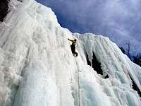
You can climb pretty much anywhere you please, and multiple parties can be accomodated. It is about 25 meters to the top of the first steep section. You can setup a top-rope anchor here (remember not to top-rope off of ice screws, build at least one Abalakov as ice screws melt out!). Alternatively, you can climb the whole thing in one pitch. There are rappel stations on the rock/trees, otherwise you have to build your own.