
-
 2657 Hits
-
 82.48% Score
-
 15 Votes
|
|
Route |
|---|---|
|
|
44.15860°N / 114.6755°W |
|
|
Hiking, Scrambling |
|
|
Summer, Fall |
|
|
A long day |
|
|
Class 2-3 |
|
|
 South Face Side Hilling
Overview
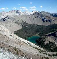 Looking back on Swimm Lake
White Cloud Peak #2 (WCP-2) is located in a remote section of central Idaho’s White Cloud Mountains. There are a couple potential route options, but the “east ridge indirect” is the only one that is realistically doable in a single day. The route starts on trail, but then sends you cross-country with some fun ridge walking and tedious side hilling along the way. You’ll also be crossing the summit of WCP-3 twice, both coming and going.
Once on the east ridge of WCP-2, it may be tempting to stay to the ridge top and traverse. If you do this, be prepared for cliff-bands that protect the ridge. IdahoKid and I attempted this route in July 2006, and were met with several exposed Class 4 sections on very loose crumbly rock. We eventually had to turn back. Having now seen the rest of the ridge from the summit, there are at least a couple sections that most would want to rope up for. The “east ridge indirect” variation allows for a much tamer option.
Getting There
The routes most likely to be used routes in reaching WCP-2 begin at the Slate Creek trailhead in the Northern White Clouds. To get there, find your way to the beautiful mountain town of Stanley, and then go northeast on Highway 75 for about 24 miles (or 34 miles southwest from Challis). Just after the highway crosses the Salmon River, look for a turnoff to the right (south) for Slate Creek. Follow the dirt road for 0.8 miles until you reach a fork. Take the left branch and follow the Slate Creek Road (FS666) until it ends at around 7 miles from where it leaves the highway.Route Description
 Map of the route.
 Final Scramble.
From the Slate Creek trailhead, follow the trail past the Slate Creek Hot Springs, old mine buildings, and mounds of silty tailings to a creek crossing. Just after crossing the creek, the trail forks with the left branch leading to Ocaulkens Lake. For WCP-2, take the right branch leading to Hoodoo Lake. The trail follows a long since abandoned mine road that switchbacks its way steeply up the mountain to the west. There are various side trails that lead off the end of switchbacks, but it is best to stay with the trail that “switches back”. In a couple miles, the trail ends at Hoodoo Lake. From the lake, circle briefly around to the northwest corner of lake and make your way up the slopes to the southwest. Soon you’ll be in a beautiful alpine basin at around 8900’ in elevation. Continue towards the back of the basin until you are parallel to the low point on the ridge to the east, which is the north ridge of WCP-3. Climb up the lightly forested slopes to the low point, and then stay on top of the Class 2 ridgeline to reach WCP-3.
After reaching the summit of WCP-3 (10588’), descend the ridge to the east until your reach the 9800’ low point, where the “indirect” portion of the route begins. Begin side hilling around the left (south) side of the ridge. There are some faint goat trails that come and go from time to time, and these are very helpful since they provide some occasional traction on the scree and talus rich slopes. You will pass a couple of rocky cliff-bands while angling across the south face of WCP-2. You can attempt to cross these, but the better option may be to descent a bit to find easier terrain. This may require around 200 feet of loss from the saddle, down to around 9600’ feet or so. Eventually you will reach a gully with a tree-lined rib on the far side (to the west). Ascent the gully until you connect with the ridge, then finish off with some easy scrambling in order to reach the seldom-visited summit.
It is around 5 miles (one way) with 4200’ of gain and 1000’ of loss (return gain) to reach WCP-2 via the “east ridge indirect” route from the Slate Creek trailhead. It’s easy to see why the peak is seldom climbed. Ten miles with 5200’ of total gain is usually enough to deter most from attempting a relatively obscure peak like WPC-2.