
|
|
Area/Range |
|---|---|
|
|
40.60398°N / 115.37636°W |
|
|
11387 ft / 3471 m |
|
|
Overview


I first became acquainted with the Ruby Mountains in early 2004 after buying property in the nearby community of Spring Creek. While the mountain views from town are certainly inspiring, they don't even begin to tell the story of the breathtaking beauty of these majestic mountains. Take a drive on the Lamoille Canyon Scenic Byway and you'll see what I'm talking about. In the middle of the arid Nevada landscape lies this paradise, a tour de force respresentative of the classic alpine mountain wilderness.
The Ruby Mountains, misnamed for the garnets found there by soldiers in the late 1800s, stretch for about 80 miles and are known as the Alps of Nevada. At the heart of the Rubies sits Lamoille Canyon, a U-shaped canyon dubbed "Nevada's Yosemite" because of the hanging valleys, towering peaks and year-round snowfields. Nevada has more mountain ranges - 314 total - than any state in the United States, and the Rubies boast the largest alpine zone of any range in Nevada. There are 25 alpine lakes and 50 peaks above 10,000 feet, including 14 above 11,000 feet with the 11,387-foot Ruby Dome claiming top honors.
The Rubies are located in remote and rugged northeastern Nevada. This is a place of solitude and beauty. Gaining access to the Rubies can be agonizingly frustrating. The most common and easiest access is via Lamoille Canyon (see Getting There for specifics). The majority of the trailheads outside of Lamoille Canyon require a 4WD high-clearance vehicle. Even some of the trailheads that you can reach by 2WD vehicle, such as John Day and Soldier Creek, involve driving great distances (>10 miles) on dirt/gravel roads) that can exact punishment on your vehicle. In other words, if you want to really see the Rubies, you're going to have to work for it. But I think it's best this way. It typifies the people of northern Nevada, who are both hard-working and hard-playing, but not necessarily in that order :) If access were more accommodating, it might tarnish the special appeal of the Rubies.
Wildlife in the Rubies include mule deer, bighorn sheep, pronghorn antelope, mountain goats, mountain lions, coyotes, badgers, muskrats, porcupines, Hungarian partridges, and blue and ruffed grouse. The Rubies, along with the nearby East Humboldt Range, are also the only places in the United States that are home to the Himalayan snowcock, introduced in the late 1960s.
SUMMERTIME IN THE RUBIES
 Island Lake drainage Island Lake drainage |
 Liberty Peak, 11036 ft. Liberty Peak, 11036 ft. |
 Alpine lakes Alpine lakes |
FALL COLORS
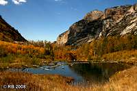 Drainage pond Drainage pond |
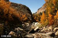 Lamoille Creek Lamoille Creek |
 Changing Canyon Trail Changing Canyon Trail |
THE CHANGING SCENES OF LAMOILLE CANYON
 July 2004 July 2004 |
 October 2004 October 2004 |
 November 2007 November 2007 |
 October 2008 October 2008 |
OTHER SCENES FROM THE RUBIES
 Lamoille Creek Lamoille Creek |
 The Terraces The Terraces |
 Secret Peak Secret Peak |
 John Day Benchmark John Day Benchmark |
 Mount Gilbert Mount Gilbert |
 Camp Lamoille Camp Lamoille |
 Bighorn sheep Bighorn sheep |
 Hennen Canyon Hennen Canyon |
 Ruby Dome Ruby Dome |
Ruby Mountains Wilderness Area
In 1989, 93,090 acres of the Ruby Mountains and the Humboldt National Forest were designated as the Ruby Mountains Wilderness Area. The majority of the Ruby Crest Trail, with the exception of the first several miles on each end, is located within the wilderness area.
Getting There
The Ruby Mountains are located about 20 miles southeast of Elko and I-80. State Routes 227, 228 and 229 head southeast from I-80 to various points in the mountain range. Directions provided here lead to the two trailheads associated with the Ruby Crest Trail, which are the most popular, Roads End in particular.
 View from Lamoille Summit View from Lamoille Summit |
 Roads End, start of Ruby Crest Trail (north) Roads End, start of Ruby Crest Trail (north) |
 Star Tungsten Mine, Harrison Pass Star Tungsten Mine, Harrison Pass |
ROADS END TRAILHEAD (LAMOILLE CANYON)
From Elko, take SR 227 south 18 miles to the Lamoille Canyon Scenic Byway. After about two miles on SR 227, you will go through the Lamoille Pass and see the Ruby Mountains. The 12-mile paved byway leads deep into the Rubies and terminates at a parking lot at 8,800 ft. elevation. At the far end of this parking lot is the trailhead for the Ruby Crest Trail.
GREEN MOUNTAIN TRAILHEAD (NEAR HARRISON PASS)
From Elko, take SR 227 south for 5 miles; turn right on SR 228 and go about 6 miles past the town of Jiggs; turn left on Harrison Pass Road and follow this to the pass. The final six miles of this drive were on a 4WD road, but I've heard that it has recently been paved or graded (not confirmed).
WINTER ACCESS
During the week of 12/15/08, the U.S. Forest Service closed Lamoille Canyon Road for the winter. The closure point is between Camp Lamoille and Thomas Canyon. Snowmobiles and ATVs are the only motorized vehicles allowed beyond the closure point.
 Lamoille Canyon closure Lamoille Canyon closure |
 Map with closure point Map with closure point |
Hiking in the Rubies
The Ruby Crest Trail, a well-maintained National Scenic Trail, is the flagship trail of the Rubies. It is 42 miles one way and runs on or near the crest of the central Ruby Mountains in a north to south general diection. The Roads End trailhead is at the north end in Lamoille Canyon and the Green Mountain trailhead, near Harrison Pass, is at the south end. See the Getting There section for diections to both trailheads.
SCENES FROM THE RUBY CREST TRAIL
 |
 |
 |
The table below summarizes hiking opportunities in the Rubies. This is a work in progress and will be updated as information becomes available.
| Trailhead | Region | 2/4WD | Length (miles) | Elevation | Latitude | Longitude |
|---|---|---|---|---|---|---|
| Changing Canyon | Central | 2WD | - | - | - | - |
| Gardner Creek | North | 4WD | - | - | - | - |
| Green Mountain¹ | South | 2WD? | 42 | - | - | - |
| Island Lake | Central | 2WD | 1.9 | 8,780' | 40.60572 N | 115.37570 W |
| Jon Day | North | 2WD | - | 6,967' | 40.77464 N | 115.32812 W |
| Krenka Creek | North | 4WD | - | - | - | - |
| Overland Lake | Central | 4WD | - | - | - | - |
| Roads End² | Central | 2WD | 42 | 8,720' | 40.60392 N | 115.37582 W |
| Ruby Guard | North | 4WD | - | - | - | - |
| Soldier Creek | North | 2WD | - | 6,728' | 40.77486 N | 115.31261 W |
| Toyn Creek | South | 4WD | - | 6,659' | 40.32512 N | 115.55988 W |
¹ This is the south trailhead for the Ruby Crest Trail, located near Harrison Pass.
² This is the north trailhead hor the Ruby Crest Train, located in Lamoille Canyon at Roads End.
Camping
Developed campgrounds are available in the area. Please see the External Links section for additional information and fees. Primitive camping is permitted at no fee. Campsites must be at least 100 feet from water sources.
Cherry Spring Wild Horse Territory

On the southern portion of the Ruby Mountain Range is the Cherry Spring Wild Horse Territory (WHT), comprised of 23,794 acres of National Forest land and 35 acres of private land. It is bordered by Sherman Mountain on the north, Overland Pass on the south, Ruby Marsh on the east, and Huntington Valley on the west. The WHT is managed for a level of 58 horses, many of which are 14.5 to 17 hands, large for wild horses. The best time to see the horses is in the winter, near the lower elevations (up to 7,000 feet) on the west side of the range. The horses work their way to the higher elevations as the snow melts.
Red Tape
For fees and other regulations, see the references in the External Links section below. USFS regulations apply. Firearms may be carried (open carry only and not concealed) in a holster.
Wilderness area rules apply in the Ruby Mountains Wilderness Area. Backcountry hiking and camping do not require any permits. There are no roads in wilderness areas. Mechanized transportation, including mountain bikes, are not permitted. All travel must be by foot or horseback. You will find no logging, resorts nor commercial uses of any kind except for grazing.
Food & Lodging
The small cities of Elko or Wells would provide the best options for food and lodging. I’m not too familiar with Wells, but Elko, though not large, is significantly larger than Wells and would have more options.
There are a number of hotels in Elko. I think the best deal in town is at the Stockmen’s Hotel and Casino. As of July 2007, a room with two twin beds went for $39.50. The rooms have AC, refrigerator, bathtub, hairdryer and many have a balcony. The hotel has a nice swimming pool and food is available 24/7 (including 24 hrs. breakfast) in the casino’s restaurant located right next to the hotel lobby. The Stockmen’s is located at 340 Commercial Street in Elko; 775-738-5141.
For good Sonoran-style Mexican food, try Sergio's on Idaho St. (between 8th and 9th Streets) in Elko. They also claim to serve the best burgers in town -- and they are! Be careful when ordering as the serving sizes are large.
Phone Numbers
Humboldt-Toiyabe National Forest: 775-331-6444
Ruby Mountains Ranger District: 775-752-3357
Elko County Sheriff Dispatcher: 775-738-3421
Fire Dispatcher (to report wildfires): 775-738-5137
Nevada Division of Wildlife: 775-738-5332
Nevada Highway Patrol: 775-738-8035
External Links
Humboldt-Toiyabe National Forest - Ruby Mountains Ranger District
Ruby Mountains Campgrounds and Trailheads
Ruby Mountain Road & Snow Report