July in Ecuador is the season for dry clear nights and mornings. . . . . but not this year!
My goal for this trip was to sleep on top of volcanoes and take videos/pics of sunrises. Unfortunately, the weather for the entire trip (except the first day. F---!) was crappy and unseasonable, especially for this purpose. After the first Saturday, there was not 1 day when the sky was clear with visibility of the volcanoes peaks. Some locals said the seasons were changing, some just shrugged their shoulders, I hung my head with disappointment. I did summit and sleep solo on top of Rucu Pichincha and Pasochoa. But after spending grueling nights on top without any picture or video worth spit for the next mornings, I decided not to overnight on my 3rd volcanoe, Ruminahui. The items I brought to overnight on the peaks were the following:
2 pair thick socks, hiking shoes plastic boot covers
Long thick underwear, jeans
Long-sleeve shirt, long-sleeve underwear top, hoodie
Balaclava
1 wool glove liner, 1 pair winter gloves
Over all this, I wore a 1-piece insulated scuba-dive suit, 1-piece motorcycle wind-waterproof suit
Slept in emergency bivy bag (the orange kind)
This was enough to keep me going, but it was still very cold because I was basically inactive for many hours leading up to the night. If I had to do it again, I would bring another pair of dry wool socks and another golver liner.
Arrival to Quito, Friday 8th
Arrive in Quito at 9PM. Taxi to hostel = $25. Hostel (Casa Kanela) located near La Mariscal area. Cost $18 for private room and shower, breakfast included (2 eggs, 2 toast, juice, and fruit). Bank to change bills 1 block away. Supermarket 1 block away. Laundry service ½ block away, luggage storage available, safe for valuables. On this street, there are 8 hostels, so if you don’t have one reserved ahead of time, just make it here and you’ll find one. Address: “Juan Rodriguez and Almagro”. Between two main streets “Colon and 6th de Diciembre”. Carlos and Gabriela—brother and sister are owners.
NOTE: No one on this site or others, posts what they pay for guides because they are too embarrassed to say so. For me, paying guides is okay, but not what they charge in Ecuador. You will not find a guide or agency on the Internet who will charge less than $160/1 person to climb a volcano. To me, that is INSANE. If you have time like I did, go there and start asking around until you get some leads.
Acclimatizing, Saturday, 9th
Breakfast and fully hydrated. Taxi to teleferico = $5. Took full backpack to acclimatize. Teleferico ride = $8.50. Save your teleferico receipt and ticket for the return trip. If you lose your ticket, you’ll end up paying 8.50 again. Slowly began hiking the trail on up. Many rest stops. Made it to where the trail meets the mountain rock and begins to traverse. Stopped here and rested for a while. Used 1 liter of water. Returned down the trail. To get back to your place, walk to the same place where the taxi dropped you off. Taxi’s will be waiting there for you. Returned to hostel for day.
![Begin 3rd part--sign]() Begin 3rd part--sign
Begin 3rd part--sign
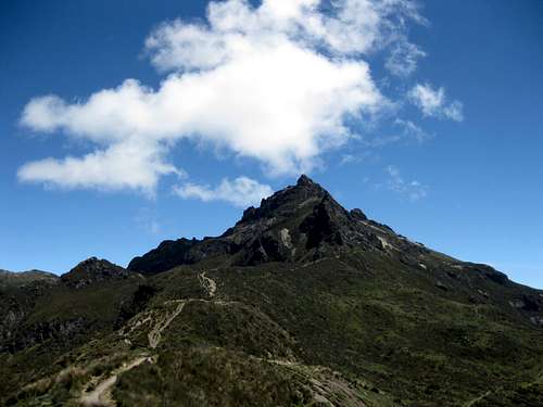
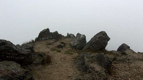
When you get to the volcanic rock surrounding the summit, there is a trail area off to the right. Stick to the right side of the rock and you being to traverse to the left. (Look for the worn-path areas). This is area requires scrambling across and up, so be careful. After a few hundred feet, you begin to make your way up to the summit. This part took me an hour to climb and I needed to take many rests. By the time I made it to the summit, I had drunk 3 of the 6 liters I had taken.
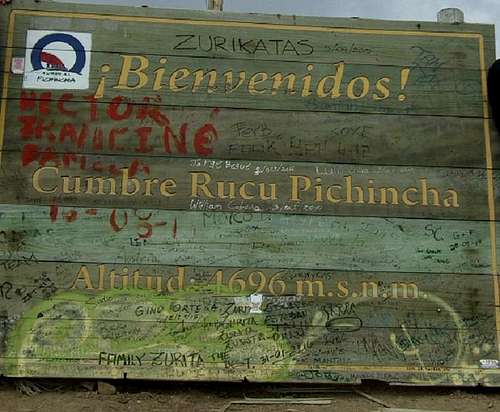
![Peak Sign]() Peak Sign
Peak Sign
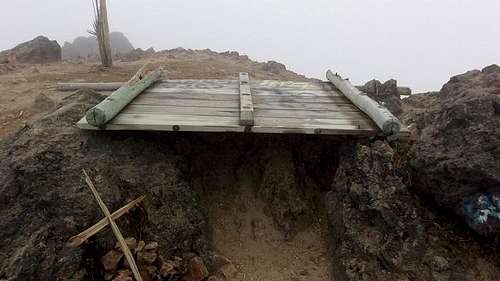
Views were limited though sunny. From about 2PM to 5PM, climbers came and went. It started to cloud over at about 430PM. The last couple made it up in the cloudy cover at 530PM and left 10 minutes later. At about 7PM I started to notice my headache. Staying at altitude is different from reaching and descending. I drank a liter and decided to save one more the evening and guard the last one to get down the next morning. Wind picked up significantly at about 8PM. By this time, I had toppled over the “Rucu Pichincha” peak sign and moved it over 2 rocks to make a shelter for the evening. Tied my tarp over part of the opening to block some wind. Used my pad for a bed, and surprisingly, it wasn’t as cold below me as I had worried. Though the wind and frozen mist caused discomfort, my biggest one was the headache. It lasted throughout the night.
![My shelter]() My shelter
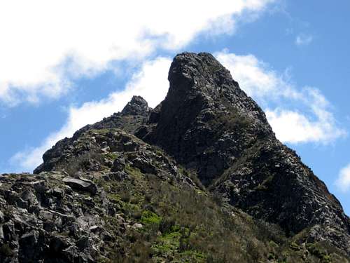
My shelter![Peak1]() Peak1
Peak1![Peak2]() Peak2
Peak2 I guess I would have acclimatized one more day before sleeping on the peak. If I come back again, I would camp 1 night half way up the volcano (before the trail traverses) and then summit the next day.
At about 900PM, while lying in my rock shelter, I heard a loud rumbling sound and the ground below me began to sway back and forth a few times. It shocked me out of my rest. It then happened again a short time after. I later found out that these were 2 earthquakes that occurred in Ecuador. Here is a news report about them:
T
wo powerful quakes measuring 5.9 and 6.4 struck the coast of Ecuador ten minutes apart, USGS reported. They appear to be aftershocks of the deadly April disaster, which claimed hundreds of lives in the country. Both quakes hit an area about 32 kilometers northwest of Rosa Zarate, a town of some 60,000 residents in the Esmeraldas province. The tremors from the two quakes were felt across a wide area and prompted many people to flee into the streets, according to BNO news. Residents reported power outages in some parts of the province. No reports as to the number of casualties were immediately available.
I didn’t know what to think, but knew that if I was going to die, that nobody would know what had happened to me. That would be a bummer. I tossed and turned trying to stay warm and trying to breathe regularly. This kept me awake until about 1AM when my mind just went to sleep.
The next day, Monday, 11th
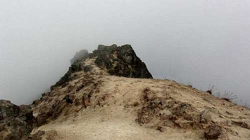
Kept tossing until 5AM, but no sun. Total cloud and mist. Until 630AM there was no sun. It appeared through a heavy cloud cover for about 4 minutes then disappeared and never came back. At 800AM, I decided to pack up and descend, but had to wait until the ultraviolet rays had melted the frost off the rocks.
![7am sun on peak]() 7am sun on peak
7am sun on peak
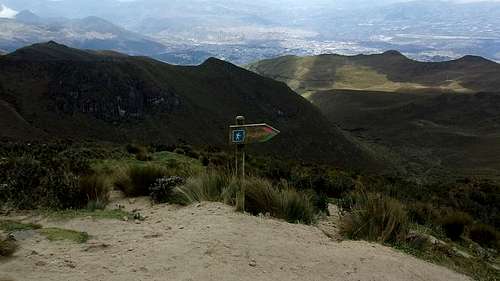
When descending, do the opposite of your ascent. Climb down a few hundred feet, then stick to your left (Look for the worn paths). Once you reach the sandy scree area in front of you, you can bounce down this area, or continue to the left among the grass outcroppings and step on down. Your key marker is the area where the pointed trail sign “9KM out of 14KM” stands. From top to this point it took me 30 minutes. Returning on the traverse part of the trail took me 30 minutes as well. From the traverse to the teleferico took me 50 minutes.
NOTE: from the teleferico to the trail traverse part, along the sides of the mountain finger, there are plenty of spots to camp for the night. I guess I wouldn’t let people know what you’re doing, but it looks safe as you can camp down among the tall mountain grasses.
Took taxi back to hostel. Washed clothes, changed money at bank, bought items from the mini-mart, went to sleep for 4 hours.
Comments
No comments posted yet.