
|
|
Mountain/Rock |
|---|---|
|
|
47.39997°N / 120.3478°W |
|
|
Chelan |
|
|
Hiking |
|
|
2228 ft / 679 m |
|
|
Disclaimer
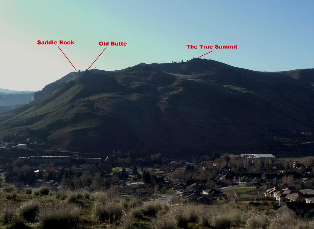
Hopefully this picture will best show to the full extent of Saddle Rock Mountain. From Chopper Peak (3/8/15)
The name of Saddle Rock Mountain came from a number of locals in town referring to this high point on the ridge. Despite the popularity of this peak and this area no one probably has written this page up on Summitpost due to the lack of information or definition on this peak. The page will also contain the scrambling rocks of Saddle Rock and Old Butte which generally have extremely little prominence. There is some confusion here because this ridgetop only has 100 feet of prominence. However there great trail that leads all the way to this high point which is the first prominent point on this long running ridge and many people in the region consider the true summit of this area. . There is no information this peak or even area on Peakbagger or ListofJohn so this is the first attempt to show this hiking peak on Summitpost.
Overview
Saddle Rock Mountain located just southeast of Wenatchee is a very popular hiking destination to all residents living in the Wenatchee area. You will find hikers of all ages, sizes, and experience level on this mountain. This hiking destination features excellent rockcrops such as Saddle Rock as well as stellar views of the city of Wenatchee and the surrounding region. On any given sunny day you can find anyone on this trail from the most novice of hikers to the most experienced hikers. Because there are no major trees here views can be seen throughout the entire hike up Saddle Mountain including on the true summit. The true has no real scramble, however the namesake landmark Saddle Rock is an exposed Class 3+ scramble. BearQueen on the true highpoint. BearQueen on the true highpoint. |  The view from the summit area. The view from the summit area. |
 Looking down from the summit to the Old Butte scramble Looking down from the summit to the Old Butte scramble |  Looking down at Wenatchee Looking down at Wenatchee |
If you are only in hiking for prominence this hike though is not for you. Saddle Mountain only has a little more than 100 feet of prominence though the area feels like a lot more when you are at the true summit. In many ways this is just a bump on a long ridge that connects to Mission Ridge. However with a large trail system, this extremely popular summit should be represented on SummitPost.
![Evening light on Saddle Rock]()
Evening light on Saddle Rock
Evening light on Saddle Rock
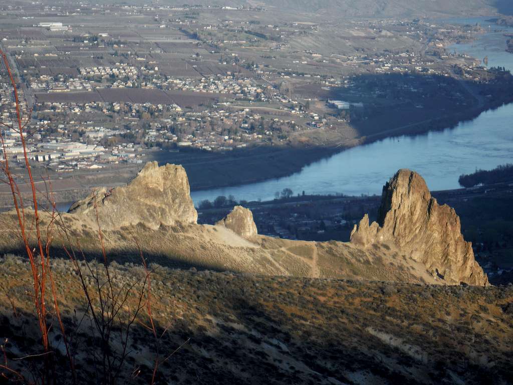
Saddle Rock Mountain is named after Saddle Rock located on the eastern side of mountain edge. Many of the hikers in the region like to end there hike here and get close to the rock outcrop. Saddle Rock is a very scenic rock and can be done as a quick but extremely exposed knife edge scramble. The moves here are not difficult but a mistake on this rock will result in certain death. There a couple of other scrambling and actual rock climbing rocks within a couple hundred yards from Saddle Rock. Another rock scrambling destination on this mountain is Old Butte which is located on the north side of Saddle Rock Mountain.

The final scramble to the top of Saddle Rock. Class 3+ and VERY EXPOSED
Getting There
VIA THE SOUTHERN ACCESS: From Miller Street head south. Veer right on Circle Street which will be the end o Miller Street. Drive a quarter of a mile and park in the parking area. Make sure not to block the any gated roads.VIA THE NORTHERN ACCESS: Take Skyline Drive west from Wenatchee. On your left will be a sign for the Wenatchee Racquet and Athletic Club. Make a left and pull in to the parking area away from the facility. There are sign stating that hikers can park there. The WRAC’s indoor facilities are only available to members so please don't attempt to enter the building. Walk Back to Skyline Drive where the trail sign will be on your right.![Map of the Route]()
Map of the Route
The basic route from the north and the south are by an excellent series of trails. From the south the route up looks more like a road until one passes Saddle Rock. The last leg of the hike up to the true summit of Saddle Mountain is more of a trail and there is some iffy footing toward the top. The top is also marked by a small rock-crop with a couple of wilted pine trees near the rocks. As mentioned in the overview, the views throughout the hike are very rewarding due to there being no trees.
![BearQueen]()
BearQueen struggling with the poor footing on the top part of the trail
Route
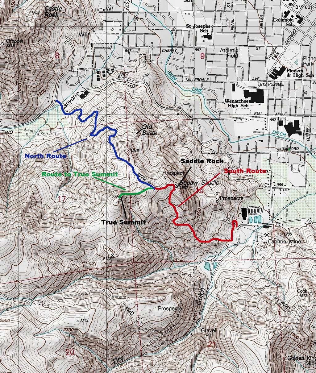
Map of the Route
 A look up at the rock formation from the trailhead A look up at the rock formation from the trailhead |  Vertical Rock Faces Vertical Rock Faces |
 The summit rock outcrop The summit rock outcrop |  BearQueen charging up the route BearQueen charging up the route |
Red Tape
Parking is available from dawn to dusk. Staying significantly after dusk causes you to risk a ticket.When to Climb
Saddle Rock Mountain can be climbed at any time however each season has its advantages and drawbacks. The perfect time to hike this peak is from mid April to early May when the flowers are out at their peak and the snake season has not really gotten going.

BearQueen struggling with the poor footing on the top part of the trail
Saddle Rock Mountain is probably be best avoided just after a rainstorm and in summer. Most of the serious trail erosion here happens when the trail is very muddy. In summer Wenatchee can easily get over 105 degrees because it is on the lee-side of the Cascade Mountains. Rattlesnakes are out at this time and can be a problem on the trail from late April to early November. Use caution up on Saddle Mountain during this time. Snow does fall here in winter but many times it does not last long. However ice can form on the trail requiring traction devices on hiking boots.