
|
|
Mountain/Rock |
|---|---|
|
|
38.17585°N / 119.36751°W |
|
|
Mono |
|
|
Hiking, Scrambling |
|
|
10325 ft / 3147 m |
|
|
Overview
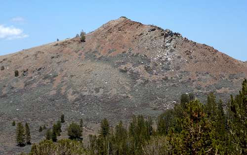
West face of Sawmill Ridge Peak
Sawmill Ridge Peak is located west of Bridgeport, California on the Sawmill Ridge north of Twin Lakes. It is referred to as Peak 10,325’ on the “Sawmill Ridge” on topographic maps or as "Sawmill Ridge" on Google Earth™. It has a prominence of over 310'. The summit is rocky, but requires only light scrambling to reach the top.
It can be hiked from the Buckeye Campground via a longer trail, or via Twin Lakes Road via a steep scramble. Either way, the views are stunning. With Eagle Peak 11,845'. to the north and the Sawtooth Ridge to the south. The Sweetwater Mountains dominate in the east along with other large Nevada peaks further in the distance.
This is an excellent destination if you want an early season trek into the Sierras with great views. Sawmill Ridge Peak can be typically be accessed by late spring, early summer. Hiking from Buckeye Campground would involve more snow, but starting from Twin Lakes is possible generally in May.
Sawmill Ridge Peak can easily be combined with the higher Robinson Peak 10,793’ by adding 2 1/2 miles round trip.
Getting There
Twin Lakes Road routeTake Twin Lakes Road from Bridgeport for about 10 miles. Before you see the first of the Twin Lakes, there is a sign for an RV park at the Twin Lakes Resort. Park at the north end of the circle beyond the buildings.
Buckeye Campground
The trailhead for the longer hike starts at the Buckeye Campground, which can be accessed from Twin Lakes Road in Bridgeport off of 395. Follow Twin Lakes Road for several miles and watch for the signs for Doc 'N' Al's resort. At the turn of there is sign heading to Buckeye Campground. The road soon turns into dirt, but can easily be driven by a 2WD. Most of the dirt section gets a "1" rating, although your car may shake at points.
Just before the campground is a concrete bridge, on the left. Cross this and drive through the campground. If you wish to camp, head to campground site #60 and see the camp host or simply find a camp site with open space, and fill out a form for that campsite and pay. If only doing a day hike, park at the Buckeye Trailhead towards the back of the campground.
Route Information
Twin Lakes Road routeThis shorter route starts at about 7,130'. There is an obvious road heading up in between two ridges leading up to the Sawmill Ridge. The road starts just to the west and continues up between the two south facing ridges. There are two options. Either continue up the road until it becomes a trail, or scramble up to the ridge on the right. The trail winds up the left side, reaching the top of the ridge in probably about 2 1/2 miles, and Sawmill Ridge Peak is less than 1/2 mile away.
If scrambling up the ridge on the right, you will encounter brush, which can be thick. However, there are sufficient animal trails to wind through it and up to the steep ridge, which is pretty straightforward. In about 2 1/4 miles, you reach the top of the ridge from the trailhead after gaining about 3,000'. Sawmill Ridge Peak is a little over 3/4 miles away.
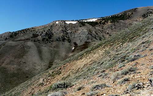
Heading up the Sawmill Ridge from Twin Lakes Road
Either route is about 6 miles round trip, with over 3,250' of elevation gain one way to the summit.
Buckeye Campground
The longer route to Sawmill Ridge Peak is via the Eagle Creek Trail. From the trailhead walk straight up the road and walk through a gate at the end of the campground. After another few hundred feet is a second gate. Walk through this gate and a couple hundred yards later is a sign on the left to Eagle Creek. Take this trail as it heads east, but soon curves back around to the west. The trail is basically an old road which continues through the forest on the right side of the creek. After about 1½ miles from the trail sign you reach the end of the road. There is a trail marker pointing to the right.
The trail continues west along the Eagle Creek and eventually the higher mountains come into view.
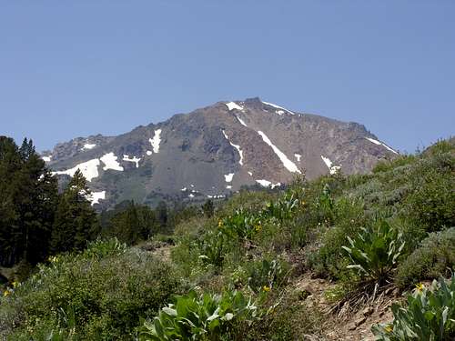
Looking up at Eagle Peak 11,845'along the trail
The trail continues up moderately steep as it climbs between the Sawmill Ridge to the south and the Buckeye Ridge to the north. Eagle Peak is in view on the right. Peak 1040 is in view straight ahead slightly left. This can be confused with Sawmill Ridge Peak. You do not have to go that far. Instead, look for a spot to cross over the Eagle Creek and onto the Sawmill Ridge. There are some open spots on the slope to the left you can view from the trail.
The total hiking distance from the Buckeye Trailhead is about 11-11 1/2 miles round trip depending on when you start the ascent. The elevation gain is about 3,100 feet.
Alternatively, a little less than 2 1/2 miles or so up the trail from Buckeye the road splits. One way heads up to the Sawmill Ridge, the other continues up towards Eagle Peak to the west. A road winds up to the Sawmill Ridge on the left and will take you to about 9,000' in about 1 3/4 miles where the road peters out. It is about 2 1/4 miles of easy hiking to Sawmill Ridge Peak. It is a little longer hike, maybe 6 1/2 miles one way, but also a good option given it enables a ridge walk to the eventual summit instead of a scramble from the forest. I have not attempted this route, so cannot give too many details. It should be obvious on Wilderness maps. It is very obvious on Google Earth™. This could be combined as a loop that is 12-12 1/2 miles round trip.
Another option is to leave one car at Buckeye and another at Twin Lakes Resort RV Park. I would recommend the steep way up from Twin Lakes Resort RV Park so you have a nice long walk through the woods back to Buckeye Campground; ideal to avoid the afternoon heat. That would be between 8 1/2 miles and 9 1/2 miles long.
Red Tape
There is no red tape to deal with and no permits required. For the shorter route, we parked just north of the RV park, and didn't have any issues.There is a fee should you choose to camp at the Buckeye Campground. However, there is also a trailhead nearby the end of the road that a person can park during the day and hike. If planning to do a longer hike in the area, it is recommended you camp at Buckeye Campground. There are 67 camp sites to choose from with space for three or four cars each. One can also camp at Twin Lakes. This is better if hiking via Twin Lakes Road, although Buckeye is recommended if hiking from the Buckeye Campground. Also, Buckeye is more simple and typically more rustic and less touristy than the Twin Lakes campground.
hightinerary - Jul 25, 2018 4:49 pm - Hasn't voted
Twin Lakes Road Route IssueIn July 2018, I was told a big mudslide took out the "obvious road heading up in between two ridges leading up to the Sawmill Ridge."
hgrapid - Jul 25, 2018 9:32 pm - Hasn't voted
Re: Twin Lakes Road Route IssueIt might be just a trail. I have to look back into it. It's a long trail to be destroyed.