
|
|
Route |
|---|---|
|
|
40.81980°N / 107.2611°W |
|
|
Hiking, Mountaineering, Scrambling, Skiing |
|
|
Summer, Fall |
|
|
Half a day |
|
|
Class 2-5 route options available |
|
|
Overview
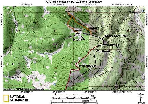
This route offers the shortest way to climb Sawtooth Mountain. From the Trailhead, Trail 1144.6 is followed east until it reaches the well marked Bears Ears Trail/Trail 1144. The Bears Ears Trail is followed Northwest before you leave the trail near Sawtooth Park and follow the base of the dike to the summit.This route is class 2 and is about four miles round trip. Several more difficult variations of the route can be climbed by those with experience.
 Sawtooth Mountain as viewed from Sawtooth Park.
Map:
The 4wd Road and east side of the Bears Ears Trail does not show up on the topo map, so they have been drawn in at the approximate location.
Red = 4wd Road.
Purple = Trails.
Orange = Off trail routes.
Getting There
From the junction of Highway 40 and 13 in Craig, turn north on Highway 13. Drive north for about 13 miles to north of mile marker 102 until you see a sign posted for County Road 27. The road is posted for “Forest Service Access” and “Black Mountain”. Drive County Road 27 through private lands for 10 miles which is where you reach the Routt National Forest boundary. The road becomes FR 110. From the Forest Boundary, follow FR 110 for 9.7 miles to FR 116. Turn right on FR 116 and drive 2.5 miles to a four way junction with FR 116, FR 1161 and FR 159. Turn right and follow FR 159 to its end. The road is rough in places, and is considered to be a 4wd road, but should be passable to high clearance vehicles such as Subarus if you drive slowly. Passenger cars will have to park early, perhaps two miles from the trailhead.If you take the right fork at the last junction you will reach a turn around which might make an alternate trailhead west of the Bears Ears.
 Autumn leaves as seen on the road to the trailhead.
Route Description
From the trailhead, follow Trail 1144.6C east. In contrast to many trails in the area, this one is easy to find, partially because it sees some ATV use.It may be tempting to cut north towards Sawtooth Mountain, but it is best to stay on the trail since there is much thick timber and deadfall around.
Stay on Trail 1144.6C until you reach a junction with the Bears Ears Trail (Trail 1144). Turn right (north) here and continue following the trail. When you are near the SE ridge of Sawtooth Mountain, leave the trail and climb up to near the base of the volcanic dike. There is a pretty easy route along a bench with game trails once you reach the base of the dike.
Continue northwest along the bench near or at the base of the dike. It is tempting to climb up to the dike early, but if you do, following the dike will become a technical climb. The north side of the dike also has thick wild rose bushes in places to, so it's best to stay on the south side of the dike. (There are many places to technical climb on the dike, if this is what you are after).
Once you are fairly near the base of the Northwest portion of the dike, which is also the highest point of the mountain, scramble and look for a break in the cliffs. Once you are on the ridge, it is an easy walk to the summit.
Enjoy the fine views before heading back down the mountain. From the summit you skirt the cliffs and head can head south or southwest to Sawtooth Park. Once in the park, follow the drainage up to where there is a bridge that is part of Trail 1144/Bears Ears Trail. From the bridge, follow the Bears Ears Trail east to the junction with Trail 1166.6C which is followed west back to your vehicle.
 Part of the lava dike on Sawtooth Mountain.