
-
 14054 Hits
-
 75.81% Score
-
 6 Votes
|
|
Area/Range |
|---|---|
|
|
22.3983°S / 42.6654°W |
|
|
Hiking, Mountaineering |
|
|
Spring, Summer, Fall, Winter |
|
|
7598 ft / 2316 m |
|
|
Resume
Serra dos Órgãos – Rio de Janeiro central mountain range – fits in this coordinates:S : -22.6140 S ; -42.6269 W – Serra da Boa Vista ( 700m ) – Cachoeiros de Macacu town.
W : -22.5785 S ; - 43.5772 W – Pico do Tinguá ( 1885m ).
N : -21.7748 S ; - 41.9348 W – Serra do Desengano – São Fidélis town .
E : -21.7390 S ; -41.6052 W – Pico do Desengano ( 1870m ).

Serra dos Órgãos - Rio de Janeiro State - Brazilian Southeast Region

RIo de Janeiro State - Serra dos Órgãos outcrops at the South/central to NE/central part
Overview
Serra dos Órgãos is formed by many mountains above 2000m, great vertical walls, greenish and deep valleys, waterfalls and great rivers. Some cities growed between this mountains like Petrópolis, Teresópolis and Nova Friburgo. The altitude average is around 850m at downtown cities. From everywhere, it’s possible to see this great mountains rounding the urban area. This range is knowed how “climbing paradise”, in prominence, Tres Picos Group and Travessia Mountains.Beautiful highways cross this range, like BR -116 to Teresópolis , BR - 040 to Petrópolis and RJ -116 to Nova Friburgo.
Serra dos Orgãos is one of the many ranges of Serra do Mar ( Coastline Range ) – The biggest brazilian range. It was the highest mountain range in the world in the past, reaching 13000m. The rock formation is a crystalline shield, covered by Atlantic Forest and altitude fields vegetation. Crossing the ages, this range was fragmented in small ranges like : Mantiqueira ( 2797m ), Bocaina( 2200m ), Órgãos ( 2316m ), Espinhaço ( 2180m ) and Caparaó ( 2894m ).
 |  |  |  |
Getting There
Because the distance of the mountains and cities, it’s advisable to visit the National Park and the State Parks. There are some APA-RJ ( State Environmental Protect Areas ) that’s forbidden the access and, State Environmental Researches. The main cities are the strategic start points to climb and hike.Getting There by bus:
From Rio de Janeiro
To Petrópolis : Viação Unifac Company ; 20/20 min everyday ; US$ 5.
To Teresópolis : Viação Teresópolis ; 30/30 min everyday ; US$ 6 .
To Nova Friburgo : Autoviação 1001 ; 30/30 min everyday ; US$ 6,50.

The highway BR-116 to Teresópolis
BR-040 to Petrópolis
 |
Serra dos Órgãos Main Groups
West to East : Showing the main places in Serra dos Órgãos.Tinguá Environmental Research
This is an untouchable area yet, because the access isn’t easy. This group is marked by the first mountains inside Serra dos Órgãos, detaching Pico do Tinguá, an impressive and isolate mountain at the west border of Serra dos Órgãos. Covered by Atlantic Forest. This mountain is protect by State and Federal laws, but, many people disrespect, setting fire and hunting inside the protected area. The overviw from the top of the mountain is awesome, lloking to South - Rio de Janeiro, West – Itaiaia ( Far away ), North – Maria Comprida Group and, East – Petrópolis region.Pico do Tinguá coordinates : - 22.58992 S / - 43.48389 W
 |  |
Serra das Araras
Serra das Araras is inside Petrópolis town, and as possible to see all mountains of this range from BR-040 highway. Maria Comprida and Pedra do Retiro are the main mountains of this steep range. This is the principal attraction is the differentiation about other places.
Pedra do Retiro – 1600m

Maria Comprida
Ventania Group
Ventania Group are urban mountains. Located at Petropolis downtown and adjacencies. They are a ramification of Serra dos Órgãos National Park mountains and form a “natural” shield for severe storms. Some mountains of Ventania Group:Pedra do Inferno 1820 m
Pico da Ventania 1780 m
Cobiçado 1690 m
Torres do Morin 1540 m
Castelinho ( Meu Castelo ) 1310m
Coordinates:
Pedra do Inferno : - 22.5273 S / - 43.09919 W
 |  |  |
Alcobaça Group
Alcobaça is located inside urban perimeter, at Petrópolis town. Driving by União - Indústria Road, it’s possible to see the bigness of this mountains. From the top of Alcobaça, the view is fantastic, almost inside the city. 3 mountains form Alcobaça group: Alcobaça, Mãe D’água and Alcobacinha.


Mãe D’água from Alcobaça
Serra dos Órgãos National Park
One of the most visited National Parks in Brazil. Localized in the central Serra dos Órgãos, there are two entrances to get the many praticable summits : From Petrópolis ( Bomfim Valley ) or, Teresópolis side ( Logistical Center ). Travessia is the long trail that connect both sides.
Serra dos Órgãos National Park mountains – Petrópolis side.

Serra dos Órgãos National Park mountains – Teresópolis side
Serra dos Órgãos National Park is reigned by severe rules. To climb hard routes inside the perimeter, the group leader has an obligatoriness to contact the Logistical Center, mentioning what the group will do; which mountain; duration and how many people climbing. Basic Informations to your own safety.
Serra dos Órgãos National Park map
Tres Picos and Bonsucesso Mountains
The highest mountain in Serra dos Órgãos is Tres Picos – 2316m. Almost whole mountains have a big wall to climb. Some with hard routes conquested, other ones unclimbed yet. Airplanes passing closely this great peak, knowed how “ghost mountain”. In 70’s, an airplaine collided there, killing by tens.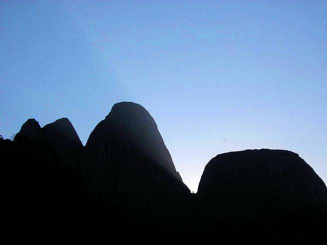
Tres Picos and Capacete
Bonsucesso is localized in the N, NW and W side of Três Picos. This mountains are the N and W boundary of APA dos Frades ( Environmental Protection Area – Frades ) Dettaching some mountains:
Torres de Bonsucesso – 2056m
Ferro de Passar Roupa – 1670m
Ronca Pedra – 2056m
Cabeça do Dragão – 2006m
Fonsecas Mountains – 2000m

Três Picos and Torres de Bonsucesso Group
Caledônia Group and Lumiar Mountains
This range is formed by 3 main groups: Pico da Caledônia – 2259m, Catarinas - 1712m and, Serra de Macahé de Cima ( Lumiar Mountains ) – 1802m. All this peaks are in the same city – Nova Friburgo. The same town but, not near. Pico da Caledônia is far 31 km from Lumiar highest mountain ( Pico da Boa Vista ).Cliffs, valleys, green forest and great rivers providing awesome views about this mountains. Arriving In Nova Friburgo, drive to Lumiar District going to the road RJ-124, Serra Mar road. To Caledônia and Catarinas, go to downtown Friburgo.

Pico da Caledônia

Lumiar Mountains

Catarinas
Serra do Desengano
Serra do Desengano was discovered by the trekkers and climbers a few years ago. With the depredation level, Desengano was proclaimed State Park, to be protect. The deforesting is the main problem to be repressed. If not, all wild area wil be transformed in pasture and, the wood, for sale.Pico do Desengano is the highest mountain of this range, reaching 1870m. Santa Maria Madalena, São Fidélis and Campos, are the towns that unites Desengano State Park. There aren’t visitors center and, just hike there if you are guided. The trails are very enclosed and there are many wrong tracks.
 |  |
Valleys
High mountains, deep valleys. The number of great valleys are countless. Some examples of Great valleys:
São Lourenço Valley – Nova Friburgo: Separates Pico da Caledônia from Três Picos.
 and Morro da Luva ( 2263m ) – 2000m.<br />
<br />
<A target=_top HREF=/mountains/photo_link.pl?photo_id=189771&object_id=5785&type=mountain&mountain_id=5785&route_id=><img class=")
Vale das Antas – Travessia – Petrópolis : The highest valley ( 2000m ) in Serra dos Órgãos. Between Pedra do Sino and Morro da Luva.
Bomfim Valley - Petrópolis : Inside Serra dos Órgãos National Park.
 |
When To Climb
All seasons are good to climb and hike, but remember : Serra dos Órgãos is a great group of mountains covered by Atlantic Forest, very close with the Ocean and very damp. At summer, I advise to visit the mountains in the same day. Do not camp at the summits or near the waterfalls, rains hard ant the weather turns lighten and rumble. The wind is threatening over there. Undergo the falls at day and watch the clouds formations. Storms could be dangerous on the summits.Winter season is perfect to camp and climb in Órgãos. Choose good days, with Sun-drenched days, with preferable full Moon. The days are clear and the temperature could drop to – 6°C.

Cold : - 6°C at Castelos do Açu – 2232m.


Summer - Storms near Caledônia summit
