
|
|
Mountain/Rock |
|---|---|
|
|
38.93680°N / 117.7736°W |
|
|
Nye |
|
|
Hiking |
|
|
Spring, Summer, Fall |
|
|
8656 ft / 2638 m |
|
|
Sherman peak by Ken Jones
Overview
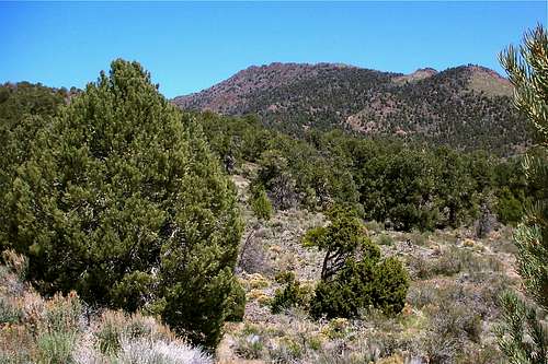
Sherman Peak is located in the western part of Nevada, southeast of Fallon. It is a rarely visited mountain, located in the Paradise Range and is of interest mainly to those who are interested in the range highpoints and peaks of nevada that have over 2000' of prominence. With almost 2200' of prominence, it comes in #137 on the Nevada prominence list.It is located in the Toiyabe National Forest, about 15 miles east of state highway 361 near the mining town of Gabbs.
Getting There
From U.S. 50, head south on Nevada highway 361 at the intersection known as Middlegate. According to a blog known as the "hamblogger", the cafe located at the crossroads makes a great hamburger. I wish I'd known that at the time when I passed by there. Well, maybe next time I'm in the area.From the turnoff at Middlegate, head south toward Gabbs for about 30 miles and prior to reaching Gabbs, look for a turnoff for NV 844 and turn left which is signed for the Berlin-Ichosaurus State Park. The road is paved and was in great shape when we were there. During the drive, the road crosses over Brunton Pass. At the nine mile mark, watch for a dirt road that heads north (lat/long nad 27 38.8941 117.7774). The road had a sign on it which was just a bit north of the turnoff. Dennis Poulin says it is FR 107 but I didn't write it down. If you use my waypoint, then you should be good. This road was rough in spots (rutted) and I would avoid it during or after a rain, but I drove another 3.5 miles to a saddle marked 7596 on the topo west of Sherman Pk and parked. 4WD was not necessary but having high clearance was nice. At the saddle of the road, there was room for several cars to park. Th 38.9365 118.7885 (7596)
Route
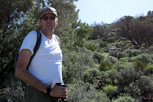
Al laughs at the brush ahead
The hike up from the parking area we used isn't difficult, it is brushy and slow until you get to the high saddle located at the 8400' mark. Once you hit this saddle, the brush is no longer a factor. Al and I took our time as we were both nursing leg injuries (me a calf muscle, Al had a bum knee). Elevation gain isn't a big factor as the overall effort is under 1200'.
I used Dennis Poulin's fine route description which can be found at peakbagger along with a GPS track. His description is as follows:
"From the saddle, hike east up the brushy hill and trend to your left. There is a saddle about .25 mile to the west of the summit and that saddle is where you want to go. If you go too far to the south, you get into some bushwhacking so stay to the left as if you are going to climb the peak that is about 7900 ft to the north. There is still some brush and lots of down trees to deal with, but it easier climbing than the bushwhacking in the little draw to the right. As you are hiking up you will notice a rocky dome along the summit ridge that looks like the highpoint. Fortunately it is not. The highpoint is to the north of the rocky dome. Once at the saddle it is easy hiking up to the summit."
I really can't add anything to his description other than there is a lot of brush to deal with until you get to the saddle mentioned. After that, the terrain opens up and it is an easy hike to the summit. My companion Al picked off one tick that was checking him out so be aware of that possibility.
 Brushy stuff
|  Smooth sailing ahead
|  Limping up to the summit
|
Red Tape & red can
None that I am aware of. The mountain is located on forest service land.Al continues hiking toward the summit and the summit itself
 Closing in on the summit
|  Yay
Yay
|  Register can hiding in the cairn
|

Red cans
Summit notes
After getting to the top, the first thing I always do is look for a register. Some peaks don't have registers and sometimes they are hidden so well I don't find them but if I do, I try nowadays to get a photographic record since registers get "lost" or the bottle containing the register gets broken and the register is ruined. Hence the reason for these pics but I've only posted a few in this section, the rest are in the photo section.Not many peakbaggers have been to this one at the present time. Probably in the neighborhood of 20+ or so since 1991. Gordon MacLeod and Barbara Lilley placed a register in 1991 but that register has deteriorated and is no longer readable. A new one was placed a couple of years ago. We found a central benchmark hidden under the rock cairn that sits on the summit and I saw one witness benchmark although there might be more.
 New register booklet
|  Not good anymore : (
|  Register page
|

Summit selfie
I found an interesting account of an ascent by Pete Yamagata and Dolores Holladay made in 1998 at this LINK. Here is an excerpt of Pete's hike:
"After camping at Berlin-Ichthyosaur State Park, from where we had toured Ione, a colorful, preserved mining town, and later the fossil site of what was said to be the largest animal (60 feet in length) that has ever existed, we drove west, Saturday morning, on the paved highway to the dirt road "107" that leads to the west side of the peak. Needing the exercise, we hiked the three miles of good dirt road to a low saddle, whereupon we headed cross-country east to the main ridge of the range. The route passes through largely brushy, pinyon-juniper covered terrain. At the saddle to the immediate north of the summit, there was a rock boundary line or low wall for about 40 feet. Knowing that primitive man had built traps to herd animals, we wondered if this could be any part of that.
We enjoyed the views, and found a 1991 register placed by Barbara Lilley and Gordon MacLeod. Only a few pages had been signed in, with the material in excellent condition, except that the non-spiral, poorly bound pages were pulling out."
Summit views

Looking south
 Northwest
|  North
North
|  East to Arc Dome
|
When to Climb

Probably just about any time of year would work although snow might be a problem in the winter and mud after or during rainy spells. Summer can be very hot so spring and fall might be the ideal seasons.
Camping

A nice state park, the Berlin-Icthysaur state park is located about another ten miles to the east from where the turn off to the peak is found. Camping fees were ten bucks a night but entrance into the park is another seven. The campsites were nice and clean and my wife was impressed with the cleanliness of the vault toilets. The park has many things to do but I'll refer you to the link HERE.
You could also camp on the forest service land most likely if you follow the leave no trace ethics. Look for spots where it is obvious others have camped before. Otherwise, the nearest lodging would be in Fallon or Austin.