
-
 9385 Hits
-
 85.87% Score
-
 21 Votes
|
|
Mountain/Rock |
|---|---|
|
|
65.55700°N / 18.25331°W |
|
|
4498 ft / 1371 m |
|
|
Overview
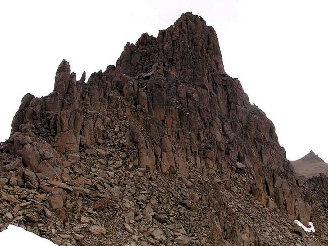
Príklakkar is the highest peak on the ridge running north/south between the northern Icelandic town of Akureyri and Kerling, the highest mountain in northern Iceland. Its companions on the ridge are (in order from south to north from Príklakkar) the double-pinnacled Bóndi, rock formations Litlikrummi and Storikrummi and Súlur. Príklakkar is characterized by a high ridge of brown blocky rock and I would have to say the most comparable American peak in design and amount of scrambling (certainly not altitude) that I know of is Hagar Mountain. There was a way to scramble up the southwest side and it appears there might be a route up the northwest side as well. Either way, it appears not too many summit this mountain as it is the most remote part of the aforementioned ridge and the trail and popular hike from Akureyri end at Súlur.
If you travel to Iceland, you really should visit Akureyri. It is an amazing town full of great restaurants and shops. And if you visit Akureyri, you really should do the hike up to the summits along the ridge to the south including Bóndi and Súlur. But, even if you chose not to climb peaks, there are plenty of other hikes in the area to do.
 |
 |
 |
 |
Getting There
Since the trailhead is the same as for Súlur and Bóndi, I will provide the same information as on my pages for those peaks:
Getting to Iceland is up to you individually although I can tell you that Icelandair flies to Reykjavik from 5 US cities: Minneapolis, New York, Boston, Baltimore and Orlando as well as most major European cities. All international flights fly into Keflavik Airport about 40 km. west of Reykjavik. From there you can rent a car from Budget, Avis, and the largest car rental place there is Hertz. I would advise booking a car/truck early and don't be surprised by the ridiculous price you are charged. I found car rental in Iceland to be about 4 to 5 times what it would be in the US.
From Keflavik, you probably will need to head to Reykjavik for supplies. Take Road 41 from the airport about 40 km east into Reykjavik until the road turns into Reykjanesbraut. You will trend north now and the road will become Fyarðarhraun. Take a right onto Rafnarfjarðarvegur and follow north until the road changes names again to Kringlumyrarbruat. Go north still approximately 6 streets and turn right onto Listabraut. Take your first left and then pull in right into the parking deck. This is the Kringlan Mall and go in and go to the Utivist store located on the bottom floor. It's a general sports store but it has the best selection I found with fuel, dehydrated food, etc.
Once you get your supplies, head out the parking deck and turn right (north) and exit out onto the large east/west road on the north side of the mall called Miklabraut. Take the road east and follow signs for Highway 1 (also known as the Ring Road).
You will go north on the Ring Road for approximately 382 kilometers to Akureyri. The Ring Road will turn into Hörgarbraut (that is a street name). Take that road to Hliðarbraut and turn right onto that street. Follow that street through most of town as it heads west. When it starts to curve to the south, you will then cross the Glera River. Just after the river, turn right onto Súluvegur. Follow this road 3.8 kilometers to a small parking lot at the unmarked trailhead. Just take note that this road turns to a dirt path and you will drive past a rubbish dump. There are a few forks in the road, just stay on the main road. Don't worry, if you get off the "road" you will quickly know it as the short side roads quickly end. At the parking lot, you will be tempted to head straight south towards the mountain but the trail actually starts off going east from the lot and will cross over a barbed wire fence via a sort of wooden staircase made for hikers to get over the fence. The trail then quickly turns south and heads in earnest for the peak.
Also, link here for possible direct flights to Akureyri.
Red Tape
No permits, fees, rules, etc. Climbing in Iceland is largely unregulated but please stick to the trail from the north to climb Príklakkar as the east slopes have homes at their base and I am not sure where private land begins and ends in this region.
When To Climb
Summer months (July - September) although this one could potentially be done year-round. (Good luck wanting to climb in Northern Iceland in the winter though) ;- )
Camping
This is a dayhike so camping is not really necessary on the peak.
For information on camping in Akureyri though:
link here for info on the town's campground
Link here for information about camping in North Iceland
General camping in Iceland link
Mountain Conditions
General Tourism Information for the area
Link for weather in Iceland
Link for road Conditions in Iceland
Other Things To Do Nearby
North Iceland has some great attractions to visit:
The next fjord over to the east has a great little town called Husavik. This is one of the major European whale watching centers. (I would recommend the company that that last link goes to, they provided a great tour as well as hot chocolate and pastries on the trip. And I DID see whales.) Also in Husavik is the Husavik Whale Center which is worth visiting.
Asbyrgi, a park within the Jökulsargljufur National Park is an amazing area with one of the few forests in Iceland. The area was carved from corrosive waters flowing from the south but is eroded in a way that shaped it like a horseshoe. It has 300 foot high cliffs in a horseshoe shape with another set of cliffs within in in the same general shape. Legend has it that it was carved by Odin's 8-hooved horse, Sleipnir, and it is easy to see how that story evolved if you visit this area.
Also not too far away is Myvatn, a highly volcanic area with an amazing lake, hot springs, sulphuric vents, etc.
Helpful Hints About Iceland
If you are considering going to Iceland, here are some suggestions:
Obtain maps online at this website. These maps show every gas station, campsite, mileage, topo lines, grocery store, etc. and were my lifeline while in Iceland.
The Icelandic language has a few extra letters in their alphabet that we don't have in English.
Þ represents "th" as in "thought"
Ð and its lower case ð represent "th" as in "that"
Ö represents "i" like in "first"
Æ represents "i" like in "fight"
There are also many rules about what sounds like what after or before other letters but the above will be enough to get you through this little mountain page.
Rent a car that is at least like a Toyota RAV 4 to get you around. If you are climbing in Iceland to get to many places, you will have to ford rivers and anything less than a RAV 4 will be useless. FYI, these currently are running about $1200 per week.