
-
 51923 Hits
-
 89.34% Score
-
 29 Votes
|
|
Route |
|---|---|
|
|
48.51170°N / 121.0567°W |
|
|
Hiking, Mountaineering, Trad Climbing, Scrambling |
|
|
Spring, Summer, Fall |
|
|
A long day |
|
|
5.4 (YDS) |
|
|
III |
|
|
Approach
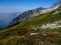
Approaching Forbidden Peak has become slightly easier over the years as the trail into Boston Basin has become more defined. To get to the designated camping area at 6,100 feet in Boston Basin, hike up the steep Boston Basin Trail through forest, then a large avalanche chute with slide alder and bushes, then reaching treeline at 5,600 feet. See the main page for more detailed information of this approach. Camp either at the upper Boston Basin designated site or in a small rock bivy on the edge of the small unnamed glacier in the Forbidden Cirque.
 Boston Basin Boston Basin |
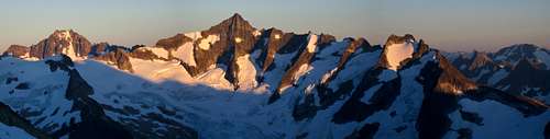
 Boston Basin Glow Boston Basin Glow |
 Sunset from Boston Basin Sunset from Boston Basin |
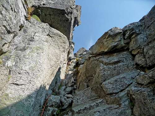
From the camp site, head slightly northwest aiming for the long gentle slabs coming down from the unnamed glacier. Avoid cutting right too soon because there is a 30-40 foot headwall you'd have to climb to reach the slabs which is difficult since it's usually wet. Once on the polished slabs veer right and head NNE up towards the glacier. Water typically always flows down these slabs so be weary to avoid slipping. In late summer and early fall, you will reach the base of the unnamed glacier at about 7,200 feet where you begin hiking on snow. This glacier has been downgraded to a permanent snowfield and most parties don't rope up to ascend it. There are some cracks still present but since it's only 5-10 feet thick, the rock slabs can be seen at the base of each crack in late summer. Use your best judgement...it still may be a good idea to rope up in early season when the cracks are still hidden. Simply pick your path and walk around the openings in the snow aiming for the large blocks at the upper end which are at 7,660 feet. It is advisable you bring crampons and an ice axe however since the snow can get quite hard and reaches about 30 degrees at the top. Once you reach the large blocks there are two variations you can take to gain the west ridge proper. Either take the west ridge couloir or the cat scratch gully, both of these variations are described below.
 Hiking the easy slabs Hiking the easy slabs |
 Looking up at Forbidden Peak Looking up at Forbidden Peak |
 Heading around a moat Heading around a moat |
 Looking down the small glacier Looking down the small glacier |
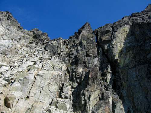
Variation 1 - West Ridge Couloir
From the base of the large blocks at 7,660 feet, stay on the snow and veer right heading around the base of the blocks. Aim for the bottom of the couloir where there will be a moderate to serious bergschrund. There may be a slight descent to avoid a small crevasse here but shouldn't pose any problems. To navigate the bergschrund, locate a snow bridge that typically forms up and to the left as you look up the couloir, above the large block protecting the entrance. Once in the couloir, which runs 40-50 degrees and can be icy, is pretty straightforward. Be prepared to use a running belay from both pickets and rock protection. There are slings all over the place on the couloir rock walls. I found the moat at the top rather entertaining as it will usually involve some creative and adrenaline-pumping climbing techniques to make it up. Exit to the left into various 4th class rock gullies, then scramble up some nasty loose terrain a short distance to the West Ridge Notch where the route begins.
This variation is best done in early season from spring through July when the couloir is in good condition. Later in the season it gets very icy and rockfall becomes a big issue. From August through the first big winter storm in October it is best to take the "Cat Scratch Gully" described in the next section.
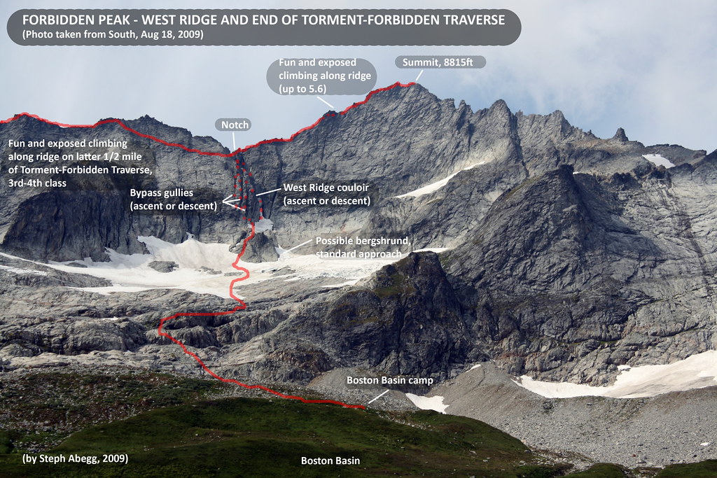

Variation 2 - Cat Scratch Gully
This variation is best done in later season and is located just to the west of the couloir. From the large blocks at the upper end of the snowfield, veer left and hike above the blocks to the end of the snow and navigate a challenging moat and ascend a loose gully to a rock bench above and to the west of the couloir. From this bench, you will notice two gullies heading up (there is actually an westernmost, third gully but you won't see this one and few climb it). The right gully is located next to and just west of the snow couloir and is the one I took. This gully is the one I recommend just because it is slightly shorter, but others say the left one is just as good. Both have many slings along the walls. Begin climbing up steep 4th class rock into the gully. This first part is the most difficult but the rock was solid here. Stay slightly left and avoid scrambling on the slabs that drop into the snow couloir to the right. I did this and found myself in a very awkward spot with one slip away from falling 70 feet onto the couloir below. Once in the gully, it narrows and it is advised you at least simul-climb this. There are plenty of slings to clip into and cracks to place cams. Halfway up the gully, it mellows and is much easier to climb. The upper part was the loosest as there was some scree in places but nothing major. Once you top out of the gully you will reach another rock bench and the exit to the couloir in variation 1 is found just to the right. Here the two variations meet and you make the same loose scramble for about 50 feet to the West Ridge Notch.
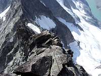
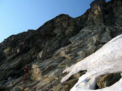 Looking up at the class 4 part of the correct cat scratch gully Looking up at the class 4 part of the correct cat scratch gully |
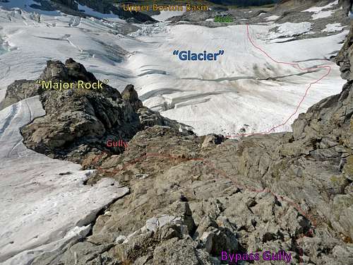 Diagram showing the route up from the small glacier Diagram showing the route up from the small glacier |
 Climbing the Cat Scratch Gully Climbing the Cat Scratch Gully |
 Final loose scramble to the notch Final loose scramble to the notch |
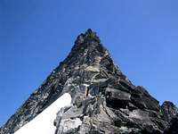
Route Description
You're now on the famous West Ridge of Forbidden Peak, one of the 50 Classic Climbs in North America. The views to Moraine Lake and Eldorado Peak are awe inspiring and the view down the spine of Klawatti Peak is as rugged as ever. The route is mostly 3rd and 4th class scrambling with lots and lots of exposure. The first two-three pitches can be (and have been) done unroped. In fact the whole thing has been climbed unroped by experienced climbers but it is advisable you continue simul-climbing up the ridge. It is important on the easy pitches to climb with the absolute minimum protection required for your personal objective and subjective danger levels in order to maximize speed. This route is often crowded and you don't want to be the group holding up the works! From the West Ridge Notch, turn right and begin ascending east. Stay on the ridge crest as much as possible and veer onto the north side of the ridge slightly to keep the climbing 4th class. Looking down the north side there is over 1000 feet of clean exposure down to the Forbidden Glacier below. Thrilling indeed! Continue traversing the ridge placing pro as needed until you get to the tower crux. You shouldn't have to belay this first part of the route, if you do you will take too long.
 Starting the W Ridge Starting the W Ridge |
 Start of W Ridge Start of W Ridge |
 Scrambling the ridge Scrambling the ridge |
 Looking down the W Ridge Looking down the W Ridge |
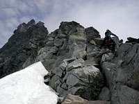
The Tower crux is the hardest part of the route. When the ridge finally goes vertical, bear around to the left and find a fixed pin in the wall (some say it was left there by Anderson and Beckey's party but it didn't look THAT old to me). Most parties decide to belay this part of the climb. Use the crack holding the piton for fingers and use the piton for protection (unless that's below your conscience). There's a nice belay platform on top of the tower. Continue up the easier ridge and when you reach what initially appears to be the top, you'll find yourself on the West Summit which 5 feet lower than the true east summit. There's a big step here that can be awkward but is best done by working left and mantling your way down onto the ledge below down into the notch. From here it's an easy but exposed walk to the true summit! The views in every direction from the summit is breathtaking. Both the East and North Ridges can now be seen and they look daunting. Time Required - From upper Boston Basin in nice weather expect 5-7 hours to the summit and 3-5 back down. Add to this time for bad visibility, sudden storms etc. Don't get caught out on this peak...there is no easy way off.
 Climbing the crux tower Climbing the crux tower |
 The False Summit The False Summit |
 Final scramble Final scramble |
Descent
Return the way you came!!! Downclimb everything you can and feel free to rappel the Tower crux. You can actually rappel the entire ridge as slings are found everywhere. Descending either the cat scratch gully or the couloir can also be done in a series of rappels using the many slings on the walls.
The "standard" descent route on Forbidden is the East Ledges (actually the NE Face) but to put it plainly this route sucks. It is also the one that has had a recorded fatality back in 1975. It's loose 3rd class with 4th class traverses around a number of rock ribs. If you haven't been on it before, turn around and descent the way you came. It may sound bad but descending Forbidden Peak is dangerous business and going down the East Ledges isn't recommended due to the confusing and loose nature of the route.
Essential Gear
Forbidden Peak Sunset
It is very important you bring the necessary gear which includes but may not be limited to:
Harnesses
Pickets
Crampons
Ice axe
Cams to 2 inches - There are no BIG cracks on this peak
Draws
Slings - There are lots of horns to sling around!
60 or 70 meter rope
Belay device and extra Carabiners
Helmets
Glacier travel gear
Rock shoes aren't needed for this climb but approach shoes were nice. Just climb what you like the most on easy 5th class terrain. One nice thing about entering and exiting the ridge from the same place is you can stow glacier gear instead of lugging it with you on the west ridge itself!
External Links
Weather Forecast
Avalanche Forecasts
Great Information for TFT and West Ridge
West Ridge via Cat Scratch Gully Trip Report
Mountain Project
chrisc - Sep 11, 2018 1:24 pm - Hasn't voted
August 2018 Trip ReportSuccessful climb trip report during the "Smoke Storm of 2018"
External trip report here