
-
 6344 Hits
-
 72.08% Score
-
 2 Votes
|
|
Route |
|---|---|
|
|
39.39260°N / 112.2072°W |
|
|
Trail hike |
|
|
Half a day |
|
|
Class 1-2 |
|
|
Overview
North Walker Canyon is one of the primary routes used to ascend Fool Creek Peak. The route begins from Oak Creek Canyon, east of the town of Oak City, Utah. Refer to the main page "Getting There" section for general directions to Oak City.
The starting point for this route will vary depending on the time of year the peak is climbed, and your tolerance and/or desire to drive on 4WD roads.
Stats
Data given here assumes a hike begining from Oak Creek Canyon road at the mouth of North Walker Canyon. For winter and early spring hikes the Oak Creek Canyon road will be gated shut at the campground; in this case add an additional walk of 1.8 miles (one-way) and 446 ft. elevation gain to the figures below.
One-Way Hiking Distance: 3.75 miles
Trailhead Elevation: 6,441 ft.
Summit Elevation: 9,717 ft.
Elevation Gain: 3,276 ft.
Average Gain per Mile: 874 ft.
Route Description
GPS coordinates appear in blue and are UTM NAD83.
From the town of Oak City, head towards Oak Creek Canyon by turning east on Center Street (look for signs indicating "Forest Camp" on the main road through the town). Follow center street east, entering the Fishlake National Forest at 3.1 miles, and arriving at the Oak Canyon Campground at 4.3 miles. In the winter the road is not maintained beyond the campground, and will remain gated shut just beyond the campground (12S 390964E 4356462N) until spring. If so, pull off to the side of the road and begin your hike here, walking the additional ±2 miles to the beginning of North Walker Canyon, otherwise continue by vehicle.
The starting point for North Walker Canyon is located ±2 miles beyond the gate near Oak Canyon Campground. The canyon is not marked so look for a large pullout (12S 393504E 4357174N) on the left (north) side of the road, and a primitive road heading north across the river. There is also a sign near with the number 1653 near the river on the right.
For those with a high clearance 4WD vehicle it is possible to continue across the river for another ±1.5 miles, but for the purposes of this route description it is assumed your vehicle will remain parked at this pullout area.
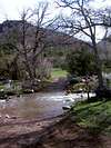
Follow the road across the stream crossing. During high runoff periods early in the season this may not be a trivial matter. For those not wanting to remove shoes to ford, another possible location to cross is approximately 100 yards downstream, where a metal culvert spans the stream.
From the north side of the stream the trail (4WD road) heads north, gaining little elevation for the first mile. Occasional side roads may be seen occasionally, but just remain on the largest and most used path.
At ±1.5 miles from the stream crossing the trail approaches a divide in the canyon, the left hand (west) side of which is Horse Hollow. The trail bends towards the right fork in the canyon, which is still North Walker canyon, passing a large rock buttress on the east wall of the canyon.
Here the trail begins climbing more steeply as it heads for the saddle, visible to the north, marking the upper end of North Walker Canyon. The trail gradually decreases from 4WD size to ATV size, until finally becoming more 'trail like'.
After making several small switchbacks the trail arrives at the saddle (12S 394480E 4360821N), at an elevation of 8,180 ft, where nice views open up to the north towards the town of Leamington.
From the saddle the summit of Fool Creek Peak will be visible directly to the east, but partially hidden by the west ridge. The summit appears deceptively close, but is still a full mile and 1500 vertical feet away.
Follow the trail east up the gently sloping ridge. The trail contours around the south side of a couple of small rises on the ridge, then continues up the final long stretch of the west ridge, passing through forested terrain along the way. The vegetation thins as the trail finally arrives on the rounded rocky summit (12S 396047E 4361044N), which is capped by an old triangulation tower.
Warning: In winter and early spring the east side of the summit may be corniced. Do not approach this side of the summit if snow is present, as the east face of the peak drops precipitously.
 |
Essential Gear
This route is an easy trail hike requiring no special equipment.
Early season hikes may be quite sloppy, so bring footwear suitable for wet and muddy trail conditions.
Skis or snowshoes will be required for winter and spring ascents.