
|
|
Route |
|---|---|
|
|
39.38010°N / 106.1355°W |
|
|
Scramble |
|
|
Most of a day |
|
|
Class 3 |
|
|
Introduction
This route is essentially a long hike followed by a perplexing Class 3 ridge. The south ridge of Wheeler Mountain is very similar to the West Ridge of Quandary Peak. Wheeler's has easier route finding, but looser rock.This is an exposed, loose climb to a pinpoint summit. Like Quandary's West Ridge, route finding is quite important to safe travel, and scrambling skills on loose rock should be polished.
That said, this is an enjoyable route to a great summit. The hike through Platte Gulch and up past the two lakes is simply gorgeous, with lots of water and several waterfalls. This is a tremendous area.
Approach
Montgomery Reservoir TrailheadFrom the South:
Go 10.7 miles north on CO 9 from the CO 9 - US 285 junction in Fairplay.
From the North:
Go 1.1 miles south of the summit of Hoosier Pass on CO 9.
Turn west onto Park County 4. There are two entrances to PC 4 - you want the northernmost one. Use the mileages above to be sure. Proceed down the hill past some homes, keep right at 0.8 miles, keep right again at 1.0 mile and go up the steep hill. You will pass an open gate, and soon see a parking area. Park 2WD cars here.
4WD vehicles can continue around the reservior and park near the Magnolia Mine. There is ample parking here.
Winter Closure is at the 2WD parking area.
The Wheeler Trail(Road)
The Wheeler Trail, which is really a 4x4 road, begins at the Magnolia mine and ends over 3 miles later at Wheeler Lake. This "road" has been adopted by The South Park 4x4 Club.
This road is one of the worst I have seen in this area. I would not take any stock 4x4 vehicle on this road. This is the kind of road that is meant for specially modified vehicles with experienced drivers. There are several very high rock steps (2-3 feet). The first is right before the Magnolia Mine. If that one looks like it is too much for you, then don't even think about going any further. They only get worse. There is evidence all along this road of oil-pan casualties.
Route Description
If you parked at the Magnolia Mine, then your first task is to walk the Wheeler Trail. It is an easy three miles from the trailhead. This "road" is very easy to follow, and it would be almost impossible to get lost. When you near the Wheeler Lake, you will pass an amazing waterfall to your right. The road here climbs steeply to Wheeler Lake. Walk to the end of the road.When the road ends, a trail begins. Finding and staying on this trail is the key to easy travel all the way to the saddle south of Wheeler Mountain's summit. Walk around the west side of the lake on the trail, and quickly arrive at an old, rusted automobile. You will also find lots of mining trash here - steel cables, tools, etc. Above you the trail skirts a small stream with several waterfalls on the stream's west side. Continue to follow the trail.
The trail leads you to an unnamed lake above Wheeler Lake. When you arrive at this lake, the now faint trail will cross the top of the stream before the lake and continue around the east side of the lake.
When you get to the north side of the lake, the trail will be even fainter. Try your best to follow it. It provides the easiest path through the large rocks. Your goal now is to climb to the saddle that is south of Wheeler's summit. The trail really does go all the way to the saddle. The final slopes leading to the saddle have steep grass. Gain the saddle.
The introduction is over. You are only 300 feet below the summit now, but you have about 1/4 mile of Class 3 terrain to negotiate until you reach it. The general idea here is to stay on the western side of the ridge and gain and lose altitude while you approach the summit, crossing rock ribs and climbing and descending gullies. The route finding can be difficult, but cairns do mark the way.
From the saddle, the South Ridge rises abrubtly above you. Avoid the temptation to take it on directly. From here, look sharp for cairns that lead you around the west side of the ridge. The scrambling meets you quickly.
In general, using the provided cairns, climb up around rock ribs and then down loose gullies until you reach the summit. You will have to do this at least 4-5 times until you reach the summit area. The summit is not apparent - but mother nature has provided us with a nice marking to guide the way. The summit proper has a "Y" of white stone on it. Also, there is a really flat (in comparison) area right before the difficulties to the summit.
To reach the summit, climb another loose gully to the south of it. You will reach a gully high point. From the high point, climb a difficult Class 3 pitch to the summit ridge. The summit is very close, but you must negotiate a very narrow, loose portion to reach it. Take your time, and enjoy your hard-won perch.
Use the following photos to guide your path to the summit. These photos do not show the entire route, but show some of the harder route finding areas. They are sequential to the summit. Take your time, and find the best path for you. This route is difficult to follow, but there is only one possible route to follow to keep it at Class 3, and they are typically obvious. In several areas, the correct path drops down a loose gully to go around a rock rib, and then climbs another gully on the other side. Expect to gain and lose a lot of altitude on the traverse.


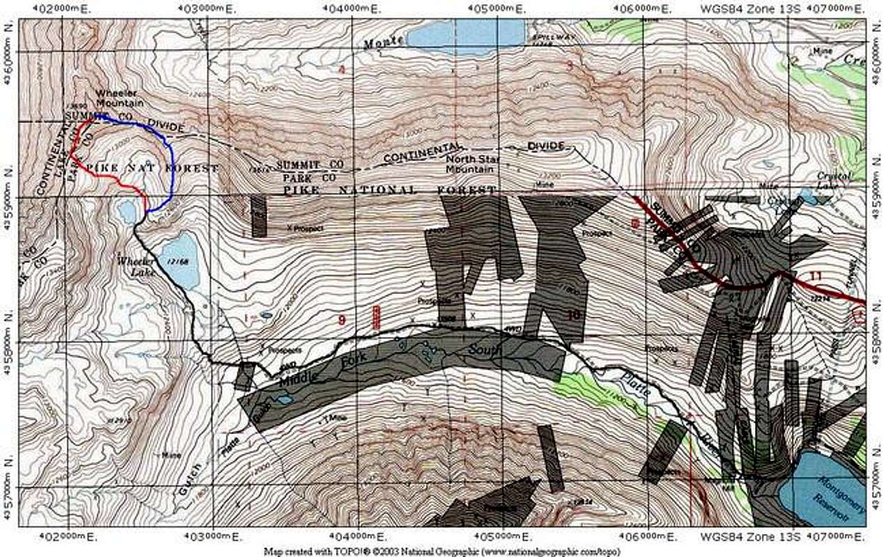
This route is in red on the TOPO
Essential Gear
A helmet would be nice for the steep, loose Class 3 rock on the ridge.Safety Notes
If you are climbing with a partner, loose rock will be a major issue. Work out a system to avoid rockfall. It is inevitable on this ridge traverse. Never climb under someone above you.The exposure isn't really staggering on this ridge, except for the summit. However, a fall in some spots will surely produce a bad injury on the loose, sharp rock. Take care.
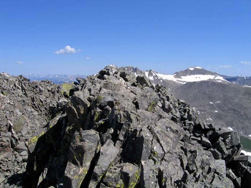
The Small, Airy Summit of Wheeler Mountain