
|
|
Area/Range |
|---|---|
|
|
33.44025°N / 105.75972°W |
|
|
11973 ft / 3649 m |
|
|
Overview

This page is currently under conversion from White Mountain Wilderness Area to Sierra Blanca Range.
Thanks for the recommendation, Bubba Suess.
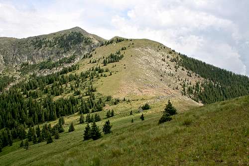
The Sierra Blanca Range (also known as the White Mountains), is a subrange of the much larger Sacramento Mountains in southern New Mexico. The Sierra Blancas run north-south for about 40 miles. The highest point in the range, as well as the southern half of New Mexico, is Sierra Blanca Peak, at 11,973 feet elevation. Sierra Blanca Peak rises 8,000 feet from the Tularosa Basin to the west, and with a prominence of 5,543 feet, it holds the distinction as the only ultra-prominence peak in New Mexico. It is also the southernmost glaciated peak in the continental United States.
The majority of the range is in the Lincoln National Forest, with a portion within the boundaries of the White Mountain Wilderness Area. Much of the southern portion of the range, including Sierra Blanca Peak, are part of the Mescalero Apache Reservation.
White Mountain Wilderness Area
The White Mountain Wilderness Area comprises 48,143 acres that lie within the Smokey Bear Ranger District of the Lincoln National Forest. 25,000 acres were designated by Congress as a primitive area in 1933 and were included in the National Wilderness System in 1964. Additional acreage was added in 1980, bringing the wilderness area to its current acreage total.
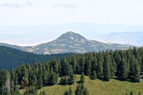
The wilderness area measures 12.5 miles long by 4-12 miles wide. Elevation ranges from a low of 6,500 feet at Three Rivers Campground to a high of 11,580 feet on the ridge near Lookout Mountain. There are four life zones in this elevation range: Pinyon-Juniper, Ponderosa Pine, Mixed conifer, and Sub-alpine forest. Up to six feet of snow can blanket the upper elevations as late as June. Wildlife in this area includes mule deer, elk, black bear, turkey, bobcats, grey fox, coyotes, badgers, porcupines, skunks and spruce and rock squirrels.

Hiking & Camping
There is a network of roughly 50 miles of maintained hiking trails with easy access throughout the wilderness area. Most of the trails tie into the Crest Trail (USFS Trail 25), which runs southwest from Monjeau Lookout to the Ski Apache ski area and then north to Nogal Canyon.Backcountry camping is permitted in the wilderness area at no fee. Find a spot you like and make sure it's at least 300 feet from any natural water source. Fires are permitted -- just dig a hole to build the fire in, make sure it's attended to at all times and that it's out and the hole is filled in before you leave the area.
There are several developed campgrounds located near the wilderness area. For detailed descriptions of the trails and camping facilities in the area, see the External Links section below.

Entry Points and Trailheads
| Trailhead | USFS Trail # | Access Road | Trail Length (miles) | Trail Information |
|---|---|---|---|---|
| Argentina | 39 | FR 107 | 2.5 | Climbs 1,280 feet to Crest Trail; live stream. |
| Bonito | 36 | FR 107 | 4.6 | Climbs 1,600 feet to Crest Trail; live stream. |
| Crest | 25 | FR 108 and FR 117 | 21.7 | Tanbark Canyon to Monjeau Lookout; panoramic views. |
| Mills | 22 | FR 107 | 4.7 | Climbs 2,560 feet from Bonito Canyon to Monjeau Lookout. |
| Nogal | 48 | FR 400 and FR 108 | 1.2 | Climbs 780 feet from Nogal Canyon to Nogal/TortolitaTrail. |
| Nogal/Tortolita | 54 | FR 400 | 2.4 | Provides main access via old wagon trail from Nogal Canyon to Tortolita Canyon. |
| Scenic | 15 | SR 532 | 0.6 | Climbs 300 feet from Ski Apache parking lot to Crest Trail. This trail is not located within the borders of the wilderness area, however, it ties in to the Crest Trail, which does lead into the wilderness area. |
| South Fork | 19 | FR 107 and FR 107C | 6.0 | Climbs 2,880 feet from South Fork Campground to Crest Trail; live stream (Rio Bonito); campground with drinking water at trailhead. |
| Three Rivers | 44 | FR 579 | 5.6 | Climbs 3,440 feet to Crest Trail from Three Rivers Campground; no drinking water at the campground. |
Getting There
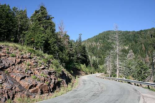
There are multiple access points to the White Mountain Wilderness. Below are the ones I am familiar with (both are accessible by 2WD):SOUTH FORK RIO BONITO (USFS TRAIL 19)
Take NM Hwy 48 north out of Ruidoso for about 10 miles; turn left onto NM Hwy 37 and go about 2 miles. This route will take you around Bonito Lake, so watch for the sign. From Hwy 37, turn left onto USFS Road 107 and go about 5 miles, including around the lake; about a half mile past Bonito Lake, go left on USFS Road 107C. Continue past the campgrounds to the end of the road and the trailhead parking lot (no fee). If you go during the camping off-season (Sept. 16 - May 14 for this campground), the entrance gate to the campground areas (and the trailhead parking lot) will probably be closed. Just find a place to park and it's about a half mile to the trailhead from this point.
CREST TRAIL (USFS TRAIL 25)
Take NM Hwy 48 north out of Ruidoso for about 6 miles; turn left onto Hwy 532 in Alto and go 12 miles to the trailhead just outside of the Ski Apache complex. This is a winding road that has several turnout opportunities to take in the view below.
Red Tape
Observe wilderness area rules. Pack it in -- pack it out; leave the area as you would like to find it. See the references in the External Links section for campsite and parking fees.Food & Lodging
Being outdoors on the trail all day can work up your appetite. One place I like to stop at in the Ruidoso area on my way out is a little joint called Can’t Stop Smokin’. This is take-out smokehouse BBQ at its best. The menu includes beef ribs, pork spare ribs, baby back ribs and brisket. Other items on the menu, in particular the garlic red potatoes, are excellent. They offer a large and unique assortment of bottled drinks as well. But back to the important part, yes, the meat. If you have the same problem I have – everything sounds good – just order yourself up a combination plate. You will get more great food than you bargained for, and at a fair price. Can’t Stop Smokin’ is along the main route going through Ruidoso, located at 418 Mechem Drive (NM Hwy 48).If you need lodging during your stay, there is a large selection of hotels and motels as well as rental cabins in the Ruidoso area to fit your budget. CLICK HERE to see lodging options at Ruidoso.net.
Phone Numbers
Lincoln National Forest: 505-434-7200Lincoln National Forest - Smokey Bear Ranger District: 505-257-4095
External Links
See the links below for information such as directions, camping and hiking. These are outstanding resources that provide a wealth of information if you're planning a trip to the White Mountain Wilderness.Lincoln National Forest - Smokey Bear Ranger District
Hiking and Camping In the White Mountain Wilderness