

surgent - Mar 10, 2011 5:02 pm - Hasn't voted
Green Line route is a goPlease see link I have provided on the main page for a trip report.
Danimal38 - Nov 2, 2013 12:12 am - Hasn't voted
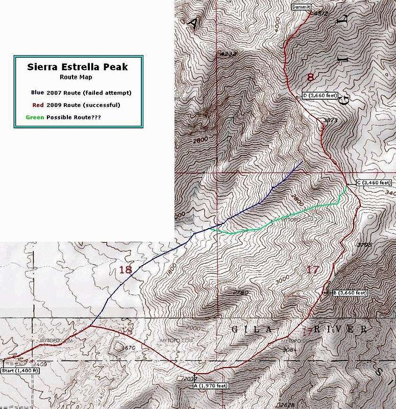
Alternative route to summitI went to the "trailhead" and camped out last night. I woke up this morning and started my ascent. I ascended two draws to the NW from the blue route. I gained the ridgeline in the saddle between peak 4232 and the sub peak SW of the summit. Time to summit via this route was 4 hours. Very strenuous. All previous descriptions of terrain are accurate as well for this route. I cairned the lower half of my route but, abandoned this endeavor in favor of conserving energy when it got really sketchy. I descended the draw from the ridgeline midway between point "D" and peak 3873. The route down took 3 hours. I would say there are multiple ways to gain the ridgeline and all pretty much suck in their own way. You just have to gut check and commit to the goal.
surgent - Nov 5, 2013 8:01 pm - Hasn't voted
Re: Alternative route to summitWell said. Glad you made it, and yes, I don't think any route on this peak is going to be a walk in the park.
3UpAdventures - Nov 17, 2013 12:42 pm - Hasn't voted
Alternative RouteI came down the steeper but more direct north-south trending drainage between the highpoint and Peak 4232 as another option for attaining the summit.

Wolverine32 - Jan 22, 2016 12:46 am - Voted 7/10
Re Aternate RouteI agree with danimal38 I just tackled this mountain last sunday, it was very strenuous I went up the green route successfully! I parked at the campsite next to the fire ring, left the truck at exactly 7:15 am got to the summit of hayes at exactly 11:20. I stayed at the summit for about 15 min took a couple of picks and went right back down. I then took the blue route down got back to the truck at 3:00pm by the time I got back to the truck I literally couldn't feel my legs! All it is, is boulder hoping the whole time and hard on the knees! You'll have a better understanding if you dare try it! And Surgent is right there is no easy way up this thing, when I got to the main mouth of the wash witch is where all the routes connect I scanned for about 10 min and hes right they all suck and theres actually about six ways up not three but try to stay with the paths in front of you and to the left this looks less harsh! And if you take the red route the whole way ad about 3hrs to the hike round trip! Good Luck!
surgent - Jan 22, 2016 1:37 am - Hasn't voted
Re: Re Aternate RouteThx for the update. Glad you made it, too. It's a peak to be proud of. I agree, the red route is no longer the suggested route, and am glad to see more people having success with the green (gully) routes and variations where people come off the peak from ridges/gullies closer to it. Going down those routes is always a little easier since you can see ways down that you wouldn't going up.


Comments
Post a Comment