|
|
Route |
|---|---|
|
|
6.40000°N / 72.2742°W |
|
|
Hiking |
|
|
Spring, Summer, Fall, Winter |
|
|
A few days |
|
|
Medium |
|
|
Overview
As of February 2017 the eastern side of the range is CLOSED, since 2013 I believe, making this circuit a little more challenging. https://www.lonelyplanet.com/thorntree/forums/americas-south-america/colombia/pnn-el-cocuy-is-closed
Day 0 - Getting to Trail Head
I missed the 0600 milk truck and didn´t want to fork the $40 for a taxi so I walked most of the way from El Cocuy to the IDEAM meteorological station (3800m) which isn´t marked on the PNN map but is 500m west of Pass J (La Cueva 3850m). I was the only guest in a very cosy and pleasant Cabaña with great views and very hospitable hosts. US$10 for a cabin and $2.50 to camp. Hitching up this road seems a pretty hopeless endeavor. I got passed by only one truck that only got me 2-3 km along the road before it turned off. The walk was nice for acclimitisation though and is about 6 hours uphill.
Day 1 - IDEAM to Pass A - 4 hours
Started early and walked very slowly south along the road from Pass J to the Lagunillas. The road quickly turns into a donkey track and it was a pretty and sunny 4-5 hours walk with a pack up to Pass A (Cusiri, 4460m) from the IDEAM. I think it took me about 7 hours though and I camped about 500m short of the pass at 4300m as the afternoon weather looked shocking on the other side of the pass. Between pass A and B is the worst weather in the region with weather coming in from the SE every day and the lack of mountains to the SE to shelter it. By the same token its nothing dangerous short of being caught up there in a thunderstorm. Track was very good all day and you´d be doing well to get lost even though it does turn off a couple times they put big obvious signs up. There are some ponds for water over a rise to the north of my Camp1. Didn´t sleep well thanks to the altitude with a nice headache to match in the morning. It was my 4th night after being in Bucaramaga at 1000m so not that quick but I wouldn´t go up any faster!
Day 2 - Pass A to Laguna de la Plaza - 4 hours
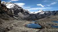
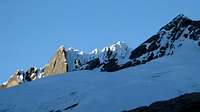
My plan to rise at 0400 to beat the rain didn´t work so Im off walking at 0700. Maybe the weather over pass A is always bad at this time of year. It´s windy as with light rain and 100m visibility but the track is excellent down to the river, basically a donkey road I guess. There is a more barren landscape across to Pass B (Patio Bolas, 4380m) where ur following some pretty huge cairns before turning left down past the pass onto another very good track to Laguna de la Plaza. I´d swear I saw some big dog or Puma prints heading off this pass away from the track, but maybe I didn´t look hard enough and it was something else. Deep in the scree it had to be something heavy. 10 minutes later I smelt some strong urine then another 2 minutes later I walk over a rise and something appears the other side 2 meters in front of me! Scared the shit out of me but was just 3 kids doing the trek, I hadn´t seen anyone for 24 hours. Either way our guide said he hadn´t seen a Puma here for 5 years. I get to Laguna de la Plaza (4350m) at 1230 and set up as the weather is clearing and I´m liking the prospect of wandering round the side of the lake in the sun and seeing if I can get a view east where the land drops away sharply to the amazon basin. Sun comes out and the high peaks and rocky expanses would have to make this the best campsite on the trek. Only view to the east in September though is cumulo nimbus clouds. Pretty cool sight seeing these huge clouds spread out mostly below you though. Im thinking I walk over Pass I (Bella Vista 4800m?) in the morning and out as the weather and my patience with solitude are running out. Thinking for sure when it starts to snow at sun down!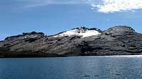
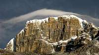
Day 3 - Laguna de la Plaza to Laguna del Pañuelo, 5-6 hours
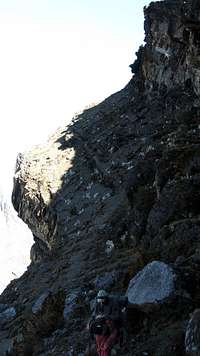
Up at 0500 to beat the afternoon rain again. Although the weather seems really random on the east of the range so I´m doubting that my plan of walking early has much merit anymore. There is no snow except on my tent! Guess the ground was too hot from the afternoon sun for it to stick around. Got a really nice sunrise at the Laguna de la Plaza except for some clouds that rose with the sun so it stayed about 50m away from shining on me, for an hour, I´m not kidding and there is nothing like having the sun on you on a freezing morning! Anyway I´m packing my things and the sun comes out, nice, and a Colombian who turns out to be my shocking guide for the next 3 days turns up about 500m ahead of his hiree. Its not guiding in my opinion when you can´t see your guide but yeah. He tells me the Bella Vista pass is dangerous without crampons and ice axe which I definently wouldn´t have believed if he told me 2 days later when I knew how much bullshit came out of his mouth but later when I took a photo of it it did look kind of steep, hairy and mostly covered in snow/ice at the top. I stupidly decide to join him, although his hiree another Aussie Rafal is a really chilled out guy and good company who I split the strangely escalating price with. Apparently $200,000 pesos (US$100) is the price Rafal was paying but now thats changed to US$200 and was never $200,000 pesos in the first place. For sure there is a con in here somewhere so I don´t know what I was thinking joining this guide but anyway. The day is amazingly sunny and in 8 or 9 slow hours we´ve had passed big snow covered mountians, georgeous valleys, red rock passes and some magnificent views to the east. Plan to take your time this day, and the next they´re the 2 best days in the remotest part of the park where there are no farms or houses. The track this day is average but just follow the cairns and head north is pretty much fine, sticking to the west of the valley for the kilometer or 2 before Pass C (Balcones, 4450m). This is the only slightly dangerous pass on the trip. on the northern side its a decently sloping scree slop that drops off a huge cliff after about 20 meters so if u slip you´re probably dead so maybe a bit dangerous if its convered in snow, that´s unlikely though. I´d say 6 hours of actually walking to Laguna Del Pañuelo (4350m) where we camped after an awful lot of arguing with Jose who constantly wanted to walk further than what we´d agreed to earlier so he could ring the work for his other job, or his sick mother, or his dog or as it actually turned out some poor American girl he´d fallen in love with on an earlier trek.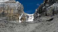
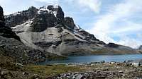
Day 4 - Laguna del Pañuelo to Laguna El Avellanal, 6-7 hours
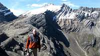
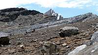
start up from the lake to Pass D (El Castillo 4600m) in an hour and a half. Walking over boulders and a little bit of walking through some hard but thin snow cover (plenty of rock around) to the pass and another spectacular valley vista, lots of snow caps either side looking over the grassy, swampy valley that is half covered in verdant green cushion plants. Its an hour or so across the valley until you start heading uphill to the lakes and pass on the other side. You can just pick any path but sticking to the left side of the river might be faster then you dont have to perform any crazy leaps across it further down. Bit swampy but gaiters not necessary, I was happy not dragging gaiters round the track. We all branched out keeping our distance from the ever annoying guide until joining up at the track again on the other side, point T in my GPS points. Once again the track from here is extremely good all the way back to the road to Guican so pretty hard to get lost. Had a nice walk up to Laguna el Avellanal (4430m) where we set up camp in the sun, argued with the guide again about not continuing on into the afternoon rain at which time he made all sorts of protestations about how dangerous the next pass was in the morning when it doesn´t rain as opposed to the afternoon, which we didnt believe. It turned out to be very easy despite how imposing as it looks from below. Also this is nice campsite.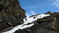
Day 5 - Laguna el Avellanal to Cabañas Kanwara, 8-9 hours
Bit of a haul this day but the best of the scenery is over once you reach the other side of pass E (De la Sierra 4700m) and you´ll probably be looking forward to the hot springs at Guican or just a shower and a bed. It was about 7 hours walking to get to Parada de Romero where there was a temporary military base set up. 4-5 hours to the Laguna Grande de Los Verdes (4070m) which has nice camping, a rock to sleep under and a sandy beach even. This is farmland though. At the military base we talked to the soldiers for a bit who are mostly conscripts as military service is compulsory in Colombia. They´re always interested in all your gear and how much it all cost which of course is very expensive for your average Colombian if you have good gear. From here our guide Jose did his one useful thing all trip and called the taxi service to pick us up, otherwise you´re walking to Cabañas Kanwara (3800m) another 1.5 hours down the road. Seemed like a nice option at this point.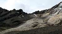
Final thoughts
Providing you´re fit and ready I think 4 days walking is a good length of time to walk round the range for the seasoned trekker. Catch the lanchero up to the end of the road near the Vivero del PNN and walk to the Lagunillas to camp or somewhere around there. Its possible to lose a day to snow or something I guess but 5-6 days from El Cocuy to Guican is about the length.Day 1 - Lagunillas - L. Plaza
Day 2 - L. Plaza - L. Pañuelo
Day 3 - L. Pañuelo - L. Avellanal
Day 4 - L. Avellanal - Cabañas Kanwara
Pass & Lake Heights
Pass A (Cusiri, 4460m)Pass B (Patio Bolas, 4380m)
Pass C (Balcones, 4450m)
Pass D (El Castillo 4600m)
Pass E (De la Sierra 4700m)
Pass F (Frailes 4260m)
Pass G (Cardenillo 4420m)
Pass J (La Cueva 3850m)
Laguna el Avellanal (4430m)
Laguna del Pañuelo (4350m)
Laguna de la Plaza (4350m)
Laguna Pintada (3950m)
Laguna Grande de Los Verdes (4070m)
Laguna el Rincon (4400m)
Getting There
There are 2 direct busses to and from El Cocuy/Bogota each day. 10 hours approx.Bogota (2600m) -> El Cocuy (2700m) at least 2 busses, no idea what time.
El Cocuy -> Bogota 0400 & 1900
El Cocuy -> Up to Pass J (3850m), close to Vivero del PNN, IDEAM etc. 45 mins.
Milk truck leaves at 0600 from the square in El Cocuy (cost? but very minimal) or you can get a taxi up for US$40. This seems to be fixed and is very overpriced for the region.
From Bucaramanga there are about 5 busses per day to Malaga (2300m) 5-6 hrs. From there catch a collectivo/taxi to Capitaejo (1000m) 1 hr. Then there seem to be 2 busses per day from there to El Cocuy, one leaves at 1530, the other in the morning, sorry I dont know what time but early!
Red Tape
Parks Pass cost me 29000 pesos (US$15). Keeps going up way above the rate of inflation though. Payable at the El Cocuy Parques Nacionales Naturales Office near the north east corner of the main square.Maps
At the PNN office in El Cocuy you can get a 1:200,000 map with 200m contour spacing. Its sufficient, just, but hard to estimate times off and routes for side trips. They don´t sell topographic maps, these are available in Bogota at the Intituto Geographical Militar I believe but expensive and printed on poor quality paper.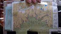
Weather, When to Visit
December is the best month, sun all day every day I´m told. January, Feburary are also good months to visit, and apparently June and July see better weather although the rest of the year there is a lot of precipitation. Very close to the equator here so the temperature is hardly changing throughout the year, just the amount of rain. I was very lucky with the weather I got in September with the sun out maybe 60% of the time. Night time temperatures are around freezing and morning freezing gales require decently warm gear. The midday sun will have you in shorts and T-shirt. Dont forget the sun is a killer at 4500, my bottom lip got pretty savaged through some light early one morning before I got to the sunscreen.
Camping
There are many good camp sites along the way although in some sections, namely either side of the passes, you might be walking for a hour or more before you find one. The campsites marked on the map are all very good and flat.Cave Camping
There are 3 caves that I know of on the route and its possible to do the whole route without a tent by sleeping in these. They have a reasonable amount of room and good shelter. Assuming you´re heading from El Cocuy South to North the first cave is between about 15 minutes before the Laguna de la Plaza campsite. Its just before my 022 waypoint although I never actually saw it so you might have to hunt around a bit there seem to be lots of tentless sleeping areas to the east of the track around here. The 2nd is a fair trek along the route (maybe 10 hours) after the first and marked on the Parks map as Cueva Larga. Its Also marked CAVE2 on my GPS route. The third cave is a 5 minute walk up a rise to the north of the western end of Laguna Grande Verde marked CAVE3. Of course this makes the trek a long 3 or 4 days but considering you have less food weight and no tent its an option for the fast fit and acclimatised!Choosing a Guiding Service
Based on my experience, DONT! In my opinion it´s more fun finding your way round by yourself and not hard, unless you have no experience. I joined up with a guide named Jose and the guy he was dragging along at break-neck speed. He doubled the price on this guy half way, constantly lied and contradicted himself about the dangers and the good places to stay just to get through things quicker, and provided basically no useful information except how many people have died here and there due to accidents or guerillas or whatever. He also yawned loudly in the middle of the night when awake just to make sure it wasn´t only him suffering the ignomity of not being able to sleep. A mountaineer in his late 30s acting like 10 year old. However I´m sure there are good guides, but if you have any trekking experience, can use a compass and a map, then no problems. The track is very good most of the way and round the eastern side in the sections it isn´t you dont need one anyway, just follow due north (or south) down the valleys and over the low of the passes following the cairns as best you can. There are some pretty big cairns around too. Nothing is too dangerous here unless there is a bunch of snow that maybe you´d like to wait out till mid morning.Mules are not an option for the full circuit as the Balcones pass (C) or certainly the boulder field between it and the El Castillo pass (D) are impassable for them.