-
 695 Hits
-
 71.06% Score
-
 1 Votes
|
|
Route |
|---|---|
|
|
11.6567°S / 75.47742°W |
|
|
Hiking |
|
|
Summer |
|
|
A few days |
|
|
Overview
This page describes a hike through the district of Yauli, located in the central sierra of Peru. Yauli is on the northern edge of the Mantaro river valley, about twenty minutes outside of the small town of Jauja. The hike follows shepherds' trails from the village of Yauli into the surrounding hills, and passes by many areas used for grazing sheep and alpaca in the highlands. As the route goes into the valley that marks the transition from highlands to jungle, the shepherds' trails end and are replaced by cattle trails, created by a herd of cattle living in the valley. This section may involve some bushwhacking and route finding, and a machete is recommended, as well as a clear sense of where you're going. It is possible to find a shepherd in the village of Yauli who knows the land and could serve as a guide. The lower third of the valley has a good trail that is regularly used by farmers from the village below. The route ends on a road at the end of the valley, from which point it is possible to find a car to return to the sierra or go deeper into the jungle.
A map of the entire route is available below in the External Links section.
Getting There
From Lima: Jauja is seven hours east of Lima.The cheapest way to get there from Lima is a bus from the terminal at Yerbateros, which should cost between S/. 15 and 30.
From Jauja, cars leave for Yauli from la Plaza de la Libertad and cost S/. 1,50 per person. To access the trailhead from the Plaza of Yauli, go down (north) one block, turn right, and follow the road until it ends at a cemetery. The trail begins just past the cemetery.
Route Description
Start at the entrance to the Yauli cemetery. Follow the trail that goes past the cemetery towards the hills. The trail soon splits, with the left fork continuing up, and the right fork moving down into the trees towards a stream. Follow the right fork. This will take you up a road with a few switchbacks that ends where the ridge above begins.
Follow the ridge up. You will see two horizontal bands in the hillside above, which are both trails used by shepherds. You should aim for the higher band because this connects to the trail above, which is still out of view at this point. Once you arrive at the high trail, follow it up. At some points the trail may not be completely visible, but if you follow it to its end, it will take you up around the southern edge of a wall of cliffs that mark the highest point on the route.


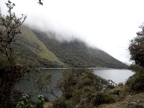
Above the cliffs is a small archaeological site from the Incans, which may be of interest. From there, you will find a drainage that runs north and eventually develops into a small valley. Follow the drainage down until you arrive at a dirt road running roughly east-west.Take the road east. Soon after turning onto the road, you will pass a small lake on your left. The road is used by shepherds to access grazing lands, andyou will pass by several huts used by shepherds, as well as herds of sheep and alpaca.


If you follow the road until it ends, you will find yourself positioned just above the valley where the jungle begins. At first, the descent is easy, but as it progresses the trail becomes less evident, and you will need to start doing more route finding. Although you can follow the riverbed at the center of the valley, it is full of large boulders and involves a lot of scrambling. Eventually the river starts going underground, and the foliage above the river is so thick that it is virtually impossible to navigate. If you are following the river at this point, it is necessary to move to the southern wall of the valley, where cattle trails can be accessed and where eventually the forest will open up as you encounter small farms and a solid trail used by farmers that comes up from down below.


The farmers' trail ends on a road that connects the town of Jauja to San Ramón, a city in the jungle below. From the trail's end, it is three kilometers uphill to the village of Curimarca, where a car can be found to go to Jauja, and twelve kilometers downhill to Uchubamba, where a car can be found to go to San Ramón. Uchubamba has natural hot springs which are open to visitors.
Commentary
We made the mistake of not bringing a machete, which would have saved some taxing hours of beating our way through the jungle brush. We were also unaware that the river would begin flowing underground,which forced us to navigate some sketchy terrain as we attempted to follow the river through the tangle of boulders, roots, and branches that create a dense network of foliage above.
We planned to complete the route in two days, but it took three. This is because we underestimated how much the jungle would slow us down.
Since we did not have any maps of the route, I took screenshots of the entire route on my smartphone using Google Earth, and was able to refer to those at any points of confusion. This was a big help and is recommended in the absence of a guide.