
|
|
Mountain/Rock |
|---|---|
|
|
36.33100°N / 81.7078°W |
|
|
Watauga |
|
|
Hiking |
|
|
Spring, Summer, Fall, Winter |
|
|
5580 ft / 1701 m |
|
|
Overview

The highest mountain between Grandfather Mountain and Mount Rogers, Snake Mountain is apart of the Amphibolite range of mountains in northern Watauga County and central Ashe County. Snake Mountain is a high ridge, contrasting to the nearby, rounded peak of Elk Knob. Snake Mountain is the northern end of a ridge and fault line that extends south to Boone. Rich Mountain Gap (4400') seperates Snake Mountain on the south from Rich Mountain Bald.
Being apart of the Amphibolite mountains, Snake Mountain is home to a unique ecosystem. A section of the ridgeline and surrounding land was recently acquired by the Highcountry Conservancy. Acquisition of land on the Amphibolite mountains through land trusts, conservation easements, and donations have been a high priority for conservation groups. Preserving this region is necessary to maintain the New River watershed (Wild and Scenic designated river) and to protect the land from commercial development.
Snake Mountain is all privately held, but access has never been a problem. Locals frequent this mountain often to hike.
 |  |  |
Getting There
[img:117920:alignleft:medium:Rich Mtn Gap in November]The best way to access Snake Mtn. is from Rich Mtn Gap Road. Rich Mtn Gap can be reached from Hwy. 421 or from Meat Camp, right before the climb to Pottertown Gap.
Driving north on Hwy. 421, take the last right before entering Tennessee onto Rich Mountain Gap Rd. The road will turn to gravel after about a mile. Take the road for about 10-15 minutes until you reach the gap, 3.2 miles later.
Coming from the east of Boone, take Hwy. 194 in Boone towards Todd for 4.3 miles. Turn left onto Meat Camp Rd. Stay on Meat Camp Rd for 3.6 miles. Right after Meat Camp Church and Pleasent Valley Church, fork left onto Rich Mtn Gap Road. Follow this gravel road to the gap, 1.7 miles. Ascending to the gap from Meat Camp is safer in adverse weather.
Once at Rich Mtn Gap, park on either side of the road next to the fence. Don't get confused and hike the wrong mountain. To the south lies Rich Mountain Bald and to the north is Snake Mountain. Both have alpine pastures adjoining at the gap.
Directions to and from Rich Mountain Gap and parking for Snake Mtn
The land is all privately owned, so use discretion.
Negotiate the barbed wire fence and enjoy the hike.
 |  |
Hiking Routes
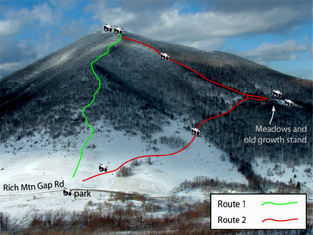
I have only hiked from Rich Mtn Gap, so I will describe the two routes I've taken from there. There are no trail markings, just some lightly used paths.
Either route takes about 30-45 minutes depending on your ability, as it is a steep climb. Vertical ascent is about 1160'.
Route 1 (green) goes steeply up the pasture and into the treeline. Stay just to the right of some large rocks and you'll find a path that follows the ridgeline to the top. In the spring and summer, wildflowers cover the ridge around the trail. This route is a steady climb, but not as steep as route 2 (red).
Route 2 (red) leads to a 'grassy knoll' with a few large old growth trees and a nice view. From the lower pasture, find a trail heading to the right. You may have to climb up a bit, but stay below the main treeline. The trail is pretty level at this point. Take the trail around the pasture and up into the trees, crossing a tiny stream. The trail will lead to the open area. From the knoll, there is no trail to the summit. Just start hiking to the west and up until you reach the ridgeline. Its steep!
 |  |  |  |
Red Tape
Snake Mountain is all privately owned, but the pasture area around Rich Mtn Gap is gameland managed by the NC Wildlife Resource Commission. This is why I've never had problems parking or hiking from Rich Mtn. Gap. Be attentive of any changes on the accessibility. Watch for any new signs, fences, or cows.Since part of the mountain is gameland, be on the look out during hunting season. I've run across a hunter on Snake Mtn., so stay alert. It never hurts to wear bright colors and walk loudly during hunting season.
When To Climb
Anytime of the year is good to hike. Though, in summer, the trail approaching the summit can become overgrown with briars and other shrubbery. |  |
Camping
I've never camped or seen evidence of others camping on Snake Mtn. There are no designated campsites, but there is room for small tents on the summit. You could always bed down in the abandoned shed that's hidden below the summit. But again, be respectful on private land.If you're overnighting in the winter, just build a snow cave.
 |
Mountain Conditions
On the windward side, Snake Mtn. rises abruptly from the valley. It is often windy on the exposed summit and storms are orographically enhanced. The weather is extreme during the winter and the mountain receives quite a higher amount of snow than surrounding locations.All-wheel drive or chains are necessary when accessing Rich Mtn Gap in the winter, even days after a snow storm.
For a local forecast, visit Ray's Weather. Ray maintains a network of weather stations in the Highcountry and understands the local microclimate. Do not trust national weather outlets for mountain weather conditions.
There is now a weather station operated by Ray on Rich Mountain, which is further south of Snake Mtn. The elevation and location match up fairly well with Snake Mtn, so use this live weather data to estimate mountain conditions for Snake Mtn.
Ray does not forecast specifically for Snake Mtn, but does give snowfall estimates for the higher mountains near the Tennessee line during the winter.
North Carolina Natural Heritage Program
[img:117506:alignleft:small:Grassy Bald community type]Snake Mountain is recognized by the NCNHP as a regionally significant natural area, but is apart of the nationally significant Amphibolite Mountains Macrosite. The Snake Mountain site contains three natural community types: Northern Hardwood Forest (2 subtypes), Grassy Bald, and High Elevation Rocky Summit.
A natural community can be an unique form of biodiversity, important in and of themselves and also important as a biofilter in regards to conserving other lesser known or unknown species. They are "reoccurring assemblages of population of species naturally associated with each other and their physical environment." Some examples are: rock outcrop, distinct forest, woodland, shrubland, and wetland types.
The High Elevation Rocky Summit community site is located on the northern ridge of Snake Mtn., while the Grassy Bald site is on the southern edge of the ridge.
Snake Mountain, in its currently undeveloped state, forms a vital connection to other nearby nationally significant sites, Long Hope Valley and Potato Hill/Rich Mtn. Bald. This provides wildlife a larger and safer habitat and aids in preserving the surrounding viewsheds.
Source:
NCNHP
An Inventory of the Significant Natural Areas of Watauga County, North Carolina.
July 2000.
Shawn C. Oakley, Inventory Biologist
Miscellaneous Info
Random note: The benchmark on Snake Mountain is on a lower point of the ridgeline, 5518 feet. However, the higher point is further south (where my photos are from) and I interpretted it to be 5580' by adding half the contour interval to highest contour elevation, 5560 feet. Further analysis of a Digital Elevation Model (DEM, 1/3 ArcSecond available from the USGS) reveals that the highest point is 5575 feet.If you have any other information about this mountain that doesn't pertain to any of the other sections, please add it here.
External Links
- Highcountry Conservancy
Details of the land acquisition on Snake Mountain
- The Sunalei Preserve
A brief description of the history around Snake Mountain
- NC Division of Water Quality
Document detailing the geography of the New River watershed and the Amphibolite mountains
- North Carolina Natural Heritage Program