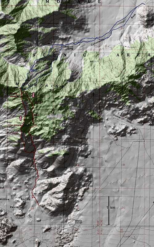
In 2015, we tried two routes to Granite from the south (shown in red). The ridge route (left) is much, much better, as the wash route (right) is choked with boulders and vicious catclaw. I would actually try to get on the ridge at least 0.25 miles before (S) of where we left the wash.
If you don't wish to drop 200' and sidehill, you will have one class 3 crux on the ridge. At ~5960', climb an obvious steep ramp on the SW side of a pinnacle (point 1832T on USGS map), to the very top. At the top, look for a steep chute on the left (W) side, heading down by some trees. Take this chute down. Do NOT take the chute at right; it cliffs-out.
When you reach the base of Granite Pinnacle (the 50' monolith 800' south of the benchmarked peak, about 6750' in elevation), go right (E) of the pinnacle and traverse to the N side. The best access to the pinnacle itself is by a class 3+ route on its NW side.
Also shown (in blue) are two routes on the N side of the mountain, in Cottonwood Basin, which I took in 2007 (before I saw the "No Trespassing" sign). As of March 15, 2015, the Cottonwood Basin was still closed to general hiker traffic, though many people poach the peak from this side. The closure is due to biological/soil studies conducted in the basin by personnel of the
UC Sweeney Research Center. See main Granite page comments for details on closure.
ROADS: HC route. From west-bound I-40, take ramp to Kelbaker Road. Travel 0.28 miles N, and keep left (N) on dirt road (the Kelbaker road turns NE at this point). Take dirt road 0.45 miles, turn left (W). Travel 0.45 miles W, and turn right (N) at former site of corral (gone, but on USGS maps). Take this road ~ N to end at Mojave Wilderness Boundary, about 1.6 miles.
Thanks to Caltopo for mapping services.


