
-
 9433 Hits
-
 82.48% Score
-
 15 Votes
|
|
Mountain/Rock |
|---|---|
|
|
49.03644°N / 121.52866°W |
|
|
Mountaineering, Trad Climbing, Scrambling |
|
|
Summer, Fall |
|
|
7402 ft / 2256 m |
|
|
Overview
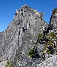
South Nesakwatch Spire is a mountain of high quality granite rising approximately 550 meters above it's surroundings just south of Chilliwack, British Columbia. The Spire offers tremendous local relief above the valley floors to the east (Centre Creek) and to the west (Nesakwatch Creek). This mountain has good access for a peak in B.C. with driving via logging roads and a good climbers trail from both the west and east sides. The mountain offers excellent views of surrounding peaks from Mount Baker, Mount Shuksan, and Mount Challenger to the south, to the Garibaldi range in the northwest, to the Cheam range in the north. Sorth Nesakwatch Spire is located between the north spire and the highest peak in the area, Mount Rexford and is 1 valley to the east of the famous Slesse Mountain. The first ascent was done by Dick Culbert, Ronald Hatch, Monte Laserre, and Arnold Shives in September of 1961.
Getting There
From Vancouver or Hope, B.C., take the Trans Canada Highway to exit #119 with a sign for Sardis. Drive south through the town of Sardis for 5.5 kilometers to just before a bridge crossing the Chilliwack River. Turn left here on Chilliwack River Road. Drive 30.3 kilometers then look for a sign that says Riverside Camp Site. Turn right here and follow the logging road to the south. At 400 meters you will reach a junction, turn right here for access to the west side of the peak via the Nesakwatch Creek trailhead. Turn left here for access to the east side of the peak via Centre Creek. This peak is most commonly approached from west. Continue driving up the Nesakwatch Creek FSR (high clearance 4wd highly recommended). Drive for 5.6 kilometers to a clearing area at 640 meters elevation. You can walk from here (2.3 kilometers of road walking) or continue up the eroded FSR road on the left. The road is not in great shape but is doable (high clearance 4wd required). Drive or walk 2 kilometers to a T then proceed left up an overgrown FSR. I'd recommend parking even a jeep at the T. Hike 300 meters up the "road" then switch back to the left. After about 100 meters, look for flagging on the right. This is the trailhead.
Route Overview

Several routes have been done on the south spire. Topos can be optained through the climbing shop, Valhalla Pure, in Squamish. I will try to get these and expand this section in the future. North Ridge - AD- II+ 5.7 6 pitches - This excellent granite ridge route provides clean rock with beautiful splitter cracks, some knife edge climbing, and a climatic finish. Recommended. Several routes have been done up clean looking corner systems on the elegant west face. More info to follow when I get the topos.
Camping
There are lots of camping options. One idea is to camp at the many campgrounds on Chilliwack River Road. There are several high bivi sites below the spires with good access to meltwater. The best one is probably at the notch directly below the southwest ridge route on the north spire. Do not go up here late season to bivi and expect water. There won't be any.
External Links
Weather Forecast #1 Weather Forecast #2
Red Tape
None