
-
 10239 Hits
-
 74.01% Score
-
 4 Votes
|
|
Trailhead |
|---|---|
|
|
48.49913°N / 113.9699°W |
|
|
Flathead |
|
|
Spring, Summer, Fall, Winter |
|
|
3200 ft / 975 m |
Southern Boundary Trail Overview:
 Looking back towards the parking area.
The Southern Boundary Trail follows the Middle Fork of the Flathead River from West Glacier to the confluence of Nyack Creek. This trail is not used a whole lot and provides access to some of Glacier's least accessed areas.
The trail passes through a Big Game Wintering Area and there might be a chance of spotting elk and deer along the open southern slopes of the Belton Hills.
Areas that can be accessed from this trailhead include Lincoln Creek and Lake, Harrison Creek and Lake as well as the incredible Nyack Drainage.
The mileage from the trailhead to the trail junctions read as follows:
Lincoln Creek Trail Junction: 5.3 miles (8.5 km)
Harrison Creek Trail Junction: 7.2 miles (11.5 km)
Nyack Creek Trail Junction: 11.8 miles (19.0 km)
The above distances ONLY shows to the beginning of the trail not the actual place. For example Harrison Lake is another 5.8 miles up the Harrison Creek Trail to the head of Harrision Lake from the above Harrison Creek Trail Junction. For the lastest trail update see Walton Section Trail Status.
There is also a trail that crosses Nyack Creek and arrives at the old Nyack Ranger Station. The trailhead to access the Nyack Area is Nyack Crossing Trailhead. This route would be an interesting day trip along the Middle Fork of the Flathead River.
The Southern Boundary Trail also continues up river from the Nyack Ranger Station to the Walton Ranger Station but it reportedly is difficult to find at times.
Peaks access along this trail: Loneman Mountain
Finding the Trailhead:
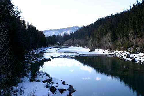
 Looking up stream from the Belton Bridge
 The Trail begins
 There's your sign
This might possibly be the easiest GNP trailhead to locate outside of Glacier National Park.
This trailhead is located just northeast of West Glacier, Montana.
While traveling in either direction along U.S. Highway 2 turn into West Glacier and drive under the railway overpass.
Pass the Canadian Visitor's Center......what in the world?......why is there a Canadian Visitor's Center in Montana?......Well at least they have clean bathrooms!
Take the first right just past Glacier Photo on to Old River Bridge. Drive for about 3/4 mile past the West Glacier Elementary School to the end of the road.
Park in the parking area and make sure not to block the GREEN BNSF Access Gate or your car may be towed.
Walk across the restored Belton Bridge and locate a sign outlining the historic Belton Bridge. The trailhead sign can also be seen from the bridge.
The Historic Marker reads:
"Built in 1920 to replace an unsafe wooden truss bridge, Belton bridge was the primary entrance into the park for nearly two decades. The bridge served as a physical connection to the west side of the park for thousands of vistors. With the construction of a new bridge in West Glacier in 1938, Belton Bridge was somewhat forgotten and allowed to deteriorate.
Events of 1964 breathed new life into the old bridge. Devestating floods that June destroyed bridges throughout the area, including the new bridge at West Glacier. When the flood waters receeded the concrete arch of the old Belton Bridge somehow remained standing. A quicly build wooden trestle aop the arch allopwed it to once again become the primary entrance to the park for two years, until the current bridge at West Glacier replaced it.
Today, Belton bridge connects us with our past. Recent rehabilitation work was sensitive to preserving aspects of both the 1920 and 1964 designs. Retention of the concrete arch and the new metal railing mimicking the original silhoutte evoke memories of the original 1920 bridge. The wooded decking and trestle work recall the post 1964 construction that allowed emergency access to the park."
Other Information:
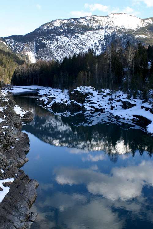
 The Middle Fork of the Flathead River
The USGS quad maps associated with this area are Lake McDonald West and West Glacier.
Get a the quad maps and Glacier National Park map from a local sporting goods store or locate them here at 7.5 Minute Topo Maps for Glacier National Park and then download them for free.
There may be little water on this route after leaving the valley floor.
This is bear country! Bring bear spray and know how to use it.
As with all hiking and climbing in Glacier National Park use caution and practice good manners with the wildlife. You are in bear country. Carry bear deterrent spray, don’t hike alone and make some noise. For more information please go to the Park's web site for Bear Information. The U.S. Forest Service also has helpful information on Grizzly Bear Management.
Check the weather before you go: