-
 10712 Hits
-
 74.23% Score
-
 5 Votes
|
|
Route |
|---|---|
|
|
36.11640°N / 115.4933°W |
|
|
Hiking |
|
|
Spring, Fall, Winter |
|
|
Half a day |
|
|
Overview
By the original page owner: From first sight Juniper Peak seems to be a technical climb; however, there's a fun class 2/3 route. This hike has plenty to offer: A trail to warm up on, bouldering through a magnificent canyon, and class 2 and 3 scrambling. Great views of Rainbow Wall and Brownstone Wall and an awesome overlook into the south fork of Pine Creek make this one of best hikes in Red Rock Canyon. If you listen carefully, you can hear climbers hundreds of feet above as you hike through Juniper Canyon.I've adopted this page for two principal reasons:
- To display some useful beta photos.
- To provide an updated, and I believe simpler, route description. However, I've retained the original description for those who might prefer it.
Getting There
From Summerlin, follow Charleston Boulevard (SR 159) west to the entrance to the Scenic Loop through Red Rock Canyon National Conservation Area ($7 per vehicle entry fee as of Summer 2013). Drive 10-11 miles to the large, signed parking area for Pine Creek Canyon.
159 is also accessible from the west via SR 160.
Route Description
RT distance is 5-6 miles with around 2000' of elevation gain. There's nothing harder than Class 3 if you follow the route correctly.
New Route Description
From the parking area, follow the trail toward the mouth of Pine Creek Canyon. Less than a mile from the start, you will come to the remains of an old homestead on the left. It’s fairly easy to miss, so keep your eyes open for it.
I repeat: the old homestead is easy to miss. So, whether you see it or not, about a half-mile from the trailhead, leave the main trail to access the best trail into Juniper Canyon, which is south of (left of) Pine Creek Canyon. Please see the pictures and captions below for additional information.
I repeat: the old homestead is easy to miss. So, whether you see it or not, about a half-mile from the trailhead, leave the main trail to access the best trail into Juniper Canyon, which is south of (left of) Pine Creek Canyon. Please see the pictures and captions below for additional information.
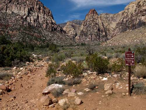 Less than half a mile from Pine Creek Canyon parking, you will reach this junction. Keep straight; just a few minutes after this junction is the key spot if you are headed for Juniper Canyon. | 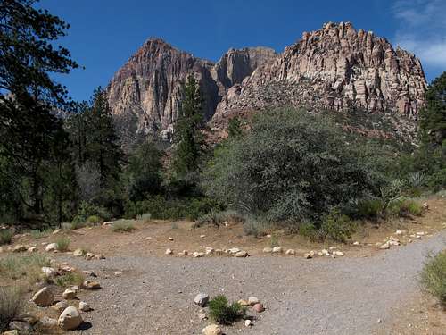 There are many use trails going off from Pine Creek Canyon to Juniper Canyon, but if you leave Pine Creek Canyon here and then cross the drainage, you can find a good use trail that leads to Juniper Canyon and stays high as you enter that canyon. It lets you avoid the brush in the wash and ultimately deposits you into the canyon where the scrambling begins. Getting into the canyon lower and earlier is going to be a mistake because it will mean negotiating brushier terrain. |
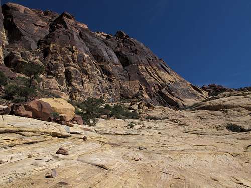
You are now in Juniper Canyon. The big walls above you and in the distance are Rainbow Wall (left) and Brownstone Wall (right). To climb juniper Peak, you will ultimately leave the canyon to access slopes at the base of Brownstone Wall.
Hop and scramble the boulders in Juniper Canyon until you see a talus field above you on the right side of the canyon. It is easy to see, and the picture below is from its base.
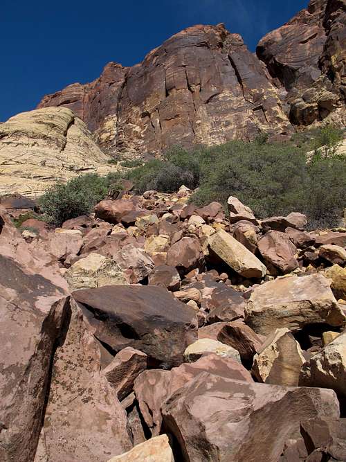
Talus Field
Clamber up the talus until you reach slickrock slopes at the base of Brownstone Wall. In 2013, there was a cairn atop the last major boulder of the talus field. It doesn't really help with navigating the talus field but does help somewhat as a locator if you are descending via this route. See the picture below.
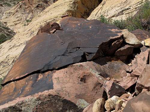
Top of the Talus Field
Now ascend the slopes below Brownstone Wall, working back north and east. Eventually, as you work to your left a bit, you'll notice a prominent chute leading steeply up the peak. In case there's any doubt, look for the numerous cairns that mark this part of the route, apparently in case someone is unsure of this only feasible-looking way up to the summit.
Route along Brownstone Wall to/from Juniper Peak
Above the chute, the route twists briefly and actually seems to be pondering a drop into Pine Creek Canyon before you reach the summit. When you squeeze between two boulders, you're almost there.
The entire route has a lot of cairns, almost all of which are completely unnecessary, to keep you on course. In my opinion, the trickiest part about the route is locating the talus field leading from the canyon to the sandstone slopes; although it is not hard to spot, missing it is likely to cost you a lot of time and energy and cause plenty of frustration.
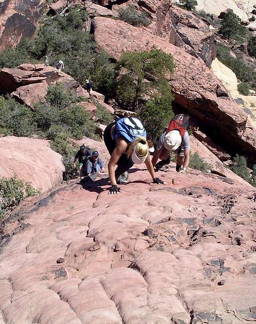
Scrambling
Original Route Description
This is the description provided by the original owner of this page. It is a good description but one I feel is so detailed that it might actually confuse people into thinking the route is harder to find and follow than it actually is. I've left it here for those who like the extra detail but have added paragraph breaks and have made some other edits to make it easier to read. Please note that this route description is more than 10 years old and that some route landmarks, especially ones involving trees and cairns, have probably changed.The path is steep but is easy to follow. It climbs to level ground and passes by a fallen log. Continue on the path about 300 yards to a two-foot-high boulder with a cairn on it.
The path divides here; take the right fork and follow it 30 yards into another wash. Go west (left) in the wash about 40 yards to an opening in the brush where a path starts. It will be to your right.
Hike 30 yards up the steep path to a small boulder field. Head SW through the boulder field aiming for a large, blackface boulder at the far side of the boulder field. A cairn sits on top of the boulder. Just to the right and little beyond the boulder, the path resumes. It travels 30 yards cutting through brush and empties out onto white sandstone.
The next part of the route parallels Brownstone Wall to a chute that is located at the north end of Brownstone Wall. The chute is your next major landmark.
Climb the wall and scramble up the chute. Hike west up the beehive sandstone. Veer north (right) and parallel the north end of Brownstone Wall 100 yards to a fantastic overlook 1,000 feet down into the south fork of Pine Creek. It’s to the north (right). After taking in the view, head south (left) just past the second of three large ponderosa pines. Traverse east (left) about 25 yards on the sandstone following numerous cairns. The route makes a 180-degree turn and heads west. Climb off the sandstone slab and under the boulder. Hike 30 yards to the pinion. Turn left (SE) and hike 20 yards going between two small sandstone crags to the crag that marks Juniper Peak.
To Descend: Retrace your steps.