
|
|
Canyon |
|---|---|
|
|
34.73800°N / 83.389°W |
|
|
Overview
 In the gorge
The Tallulah River, which is the erosionary engine that has carved the place, has been dammed and otherwise diverted by the Georgia Power Company above the gorge, thus greatly reducing the volume of water that flows through Tallulah Gorge. The falls there, while still impressive, are but ghosts of their former power and appear by comparison to be merely trickles of the rapids and great waterfalls that greeted viewers early in the 20th century.
Most of the gorge is now protected within the borders of the Tallulah Gorge State Park due to efforts by conservation groups and by the very large and powerful Georgia Power Company that had previously owned most of the land inside the gorge. The rim of the gorge is often very crowded, and it is difficult to find a place beyond the noise of motorcars and human voices. Also, some development has occurred on the rim of the gorge in the form of roads, houses, and business, so that there is almost no chance for a wilderness experience there.
However, the slopes and base of the gorge are well-protected by the state and one can find solitude and quiet 700 to 1000 feet below the lip of the rim.

 |  |  |
Getting There
Most people gain access to the gorge via the North Rim Trail and Hurricane Falls Trail just beyond the Jane Hurt Yarn Interpretive Center inside Tallulah Gorge State Park. The park is located along Georgia 441 inside the city limits of Tallulah Falls, Georgia. If traveling north, make a right into the park. If headed south, take a left. Follow the signs to the Jane Hurt Yarn Center.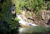 |  |  |
Red Tape
If one is hiking merely the Rim Trail (north or south rim) and the Hurricane Falls Trail, then no permit is required. But if you wish to travel off of these trails and into the gorge, then you must apply for a permit. Only 100 people are allowed into the gorge itself each day. This is usually more than enough permits, but on some days you will find yourself on the wrong side of 100. I would suggest arriving early for any trip into the gorge.There is a $4.00 charge per vehicle to enter the park.
There are no charges of which I am aware for climbing or rappeling, althoug as I understand it, these are activities which are included in the "first 100 persons" rule.
Access to off-trail use in the gorge is strictly enforced. Don't attempt to break these rules.
 |  |  |
When To Climb
For hiking, I would suggest all year. The elevation is low enough so that this area rarely gets a heavy snowfall or extreme icing and low temperatures. Climbing is allowed, but check with the park service for information regarding climbing. |  |  |
Camping
Camping is allowed at the developed campground in Tallulah Falls State Park. Tent and RV camping.There are limited back country camping opportunities near the gorge on the Stoneplace Trail (a 15+mile trail connecting Tugaloo Lake with the Interpretive Center).
Call the park for current fees: (706) 754-7970.
 |  |  |
Mountain Conditions
Check the weather for Tallulah Falls, Georgia, which is located near the south rim of the gorge. |  | 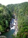 |
External Links
- Tallulah Gorge State Park.
The official Georgia State Park site for Tallulah Gorge.