-
 7119 Hits
-
 85.36% Score
-
 20 Votes
|
|
Mountain/Rock |
|---|---|
|
|
44.18750°N / 113.4787°W |
|
|
Custer |
|
|
Hiking, Mountaineering, Scrambling |
|
|
Spring, Summer, Fall, Winter |
|
|
8644 ft / 2635 m |
|
|
Overview
Taylor Mountain sits at the southeast of the Donkey Hills inside the Red Hill Quadrangle, northwest of Hawley Mountain in the southern boundaries of the beautiful Pahsimeroi Valley.Surrounded by the Lost River Range and the Lemhi Mountains, it is a very fun and rewarding hike that will leave you many photo opportunities. The climb/hike is about 1700 ft of elevation gain and about 4 miles round trip. Spring conditions will take you 2.5 - 4.0 hours total.

Getting There
From BoiseTake I-84 east to Mountain Home where you will take exit 95 to highway 20. Follow highway 20 all the way through Fairfield, Carey, and Craters of the Moon to Arco. At the major T intersection in Arco turn right to continue following highway 20. If you turn left you will end up in the Big Lost River Valley which is a cool place but is not where you want to be. After turning right in Arco you will soon leave town, pass through Butte City, and work around the Southern edge of the Lost River Range. A few miles after Butte City there will be a major turnoff with a sign directing you to Howe/Highway 33. Turn left here. If you reach the sign telling you you've entered the INL (Idaho National Laboratory), you've gone a little too far. After some time you'll come to the very small town of Howe.
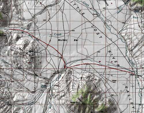
At this point you will enter the beautiful Little Lost River Valley. In about 30 miles you'll come to Clyde which is nothing more than a small ranch. To the left you'll see a sign directing you to Wet Creek via Pass Creek Road. This is not where you want to turn but it is good to know since Clyde is not signed at all.
At Clyde, take Wet Creek Road 6.5 miles to Dry Creek Road, turn Right and go to 12.5 mile mark (total) or point where road is closest to NE ridge.
Campground is on Wet Creek- at about 6 miles, turn left right after you cross the creek.
From Pocatello
Take Interstate 15 north to the Blackfoot/Highway 26 exit. Turn left. Stay on Highway 26 until it intersects with Highway 20 coming from Idaho Falls. Turn left on Highway 20 past the INL and past the rest area on the left (this is the only public restroom before you reach the campsite). You will begin to look for signage to Howe (Highway 33, the Little Lost River Highway) after this point. Turn right at the 3-way intersection and continue on to Howe.
At this point you will enter the beautiful Little Lost River Valley. In about 30 miles you'll come to Clyde which is nothing more than a small ranch. To the left you'll see a sign directing you to Wet Creek via Pass Creek Road. This is not where you want to turn but it is good to know since Clyde is not signed at all.
At Clyde, take Wet Creek Road 6.5 miles to Dry Creek Road, turn Right and go to 12.5 mile mark (total) or point where road is closest to NE ridge.
Campground is on Wet Creek- at about 6 miles, turn left right after you cross the creek.
From Idaho Falls
Take Highway 20 west past the INL and past the rest area on the left (this is the only public restroom before you reach the campsite). You will begin to look for signage to Howe (Highway 22/33, the Little Lost River Highway) after this point. Turn right at the 3-way intersection and continue on to Howe.
At this point you will enter the beautiful Little Lost River Valley. In about 30 miles you'll come to Clyde which is nothing more than a small ranch. To the left you'll see a sign directing you to Wet Creek via Pass Creek Road. This is not where you want to turn but it is good to know since Clyde is not signed at all.
At Clyde, take Wet Creek Road 6.5 miles to Dry Creek Road, turn Right and go to 12.5 mile mark (total) or point where road is closest to NE ridge.
Campground is on Wet Creek- at about 6 miles, turn left right after you cross the creek.
Camping
8 miles into the drive you will come across a campground at Squaw Springs and Wet Creek just off the road.Trip Reports
Splattski Trip Report