Toggle navigation
Mountains
Routes
Images
Trip Reports
Forum
What's New
People
Areas & Ranges
Articles
Trailheads
Canyons
Huts & Campgrounds
Albums
Logistical Centers
Fact Sheets
Lists
Custom Objects
Gear
Plans & Partners
WELCOME TO SUMMITPOST
SIGN IN
REGISTER
Scotts Bluff National Monument
Additional Parents
Image
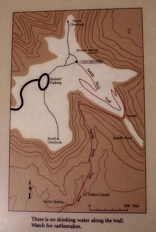
This photo shows the Saddle...
View High-Resolution Image
This photo shows the Saddle...
This photo shows the Saddle Rock Trail (the only official summit trail). The bold path seen is the road that leads to the parking lot near the summit. The thin red line is the actual hiking trail that leads to the summit from the Visitor's Center.
« PREV
NEXT »
Trevor Simmons
on
May 30, 2005 4:16 pm
Comments & voting
Other parents
Lat/Lon:
41.83860°N / 103.7°W
Image ID:
107480
2180 Hits
69.78
% Score
2
Votes
Log in to vote
Comments
No comments posted yet.
to post!
Don't have an account?
Scotts Bluff National Monument
(Mountain/Rock)
« PREV
Viewing
#45 of 49
GALLERY
NEXT »
Trevor Simmons's Image Gallery
« PREV
Viewing
#268 of 288
GALLERY
NEXT »
Saddle Rock Trail
(Route)
Loading....
×
You need to login in order to vote!
User Name
Password
Remember me
Forgot your password?
Log me out when I close my browser.
Keep me logged in all the time.
sign in as a user
Don't have an account?
Register now for FREE
Rating available
Suggested routes for you
People who climb the same things as you
Comments Available
Create Albums
Register Here


