
-
 15964 Hits
-
 85.81% Score
-
 21 Votes
|
|
Mountain/Rock |
|---|---|
|
|
45.73256°N / 122.04972°W |
|
|
Skamania |
|
|
Scrambling |
|
|
Spring, Summer, Fall, Winter |
|
|
3550 ft / 1082 m |
|
|
Overview
Three Corner Rock is actually a large pile of huge basalt boulders rising to a summit altitude of 3,550 feet in the southern Washington Cascades. Viewed from the south, it looks as though it is precariously tipped in a westerly direction and indeed, many of those big boulders look like they are ready to tumble down the sides of the peak.
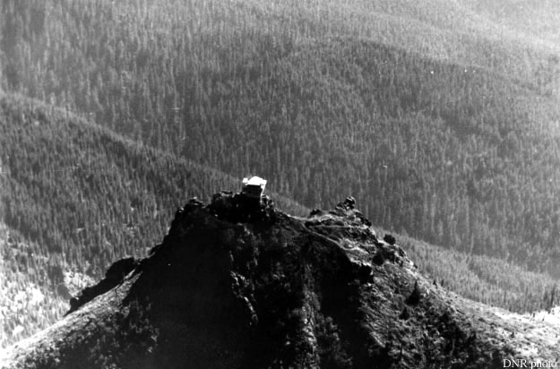
The summit rockpile of Three Corner Rock
Visible from most of the far NE side of the Portland metro area, it’s easy to spot due to its distinctive nipple-like profile on the near NE horizon.
The mountain once sported one of the ubiquitous forest service fire lookouts and the remains of the foundations can be seen on the summit blocks. It’s easy to see why the site was chosen since commanding views in all directions can be had: Five of the major peaks: Rainier, St. Helens, Adams, Hood and Jefferson are in full view and dozens of smaller peaks can be easily seen, including most of the main Columbia Gorge mountains from Defiance to Larch on the Oregon side and Dog to Zion on the Washington Side.
(For a look at the old lookout, click this link: Lookout
The Yacolt Burn of 1902 swept in from the east, up and over the entire peak and surrounding area on Sept. 11th, 1902, and remains of the larger old growth giants still stand in places on the slopes of the peak. The climate (and possibly subsequent fires and loss of topsoil due to the original fire) has not allowed a forest to re-grow in much of the upper reaches and large areas of mountain huckleberries blanket the slopes making this an abundant berry gathering spot in late summer and early fall.
Getting There
The peak is reachable from the SW on the Three Corner Rock Trail, from the north via the PCT and a short spur trail, and for you gluttons-for-punishment, from the south via the Table Rock Trail and the PCT. This last is my favorite: The minimum distance from the south is 21.7 miles and 5,400 vertical feet gained in total for round trip. (For true gluttons-for-punishment, you can grab Aldrich Butte, Table Mountain, South Birkenfeld and Birkenfeld along the way for an epic 25 mile, 7,500’ vertical day if you really need to slim down for the climbing season!)For a view of the trail system near the summit see the map in the picture section.
There is a small microwave relay facility a short distance SE of the peak so a 4WD road is available for mountain bikers and other suitable vehicles once the snow is gone (there are still a few piles of snow in the area as of July 4, 2008!) but doing this peak by car is cheating and besides, it will definitely beat up even an SUV since the last mile or so the gravel averages about 6 inches in diameter.