
|
|
Mountain/Rock |
|---|---|
|
|
48.76376°N / 119.92008°W |
|
|
Okanogan |
|
|
Hiking, Mountaineering |
|
|
Spring, Summer, Fall, Winter |
|
|
7083 ft / 2159 m |
|
|
Overview
Thunder Mountain is a peak located in the Okanogan National Forest of Washington State. Centrally located between much more popular hiking destinations Windy Peak (to the north) and Tiffany Mountain (to the south), Thunder Mountain offers an easy off-trail side-trip for outdoor enthusiasts traveling in the region.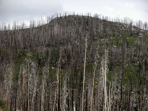 Thunder Mountain
Thunder Mountain gained regional attention when a 1994 wildfire, called the "Thunder Mountain Fire", burned 8000 acres of lodgepole pine forests in the area. To combat the fire, firefighters created 18 miles of fire line by bulldozing into the Long Swamp roadless area through a watershed designated as critical for salmon under the Clinton administration’s recently-passed forest plan. The firefighters also neglected to realize the importance of fires to the stability of lodgepole pine forests, as the heat from forest fires open the resin-sealed pine cones, allowing them to germinate. Instead, the firefighters knocked down thousands of pine trees along Smarty Creek (on the west side of the mountain) as well as other local streams. The established fire lines and firefighting methods did not help contain the Thunder Mountain Fire. Ultimately, and possibly embarassingly, the wildfire was contained and extinguished naturally... when two inches of rain fell on the area in a 24-hour timeframe. Unfortunately, the actions of the firefighting techniques left a lasting impact on the landscape surrounding Thunder Mountain. It might be decades before lodgepole pines again grow in specific areas near the mountain.
 Western Slopes
The mountain was then ravaged again by a wildfire, the Tripod Complex Fire in Summer 2006. The Tripod Complex Fire covered more than 175,000 acres of forest land, an area approximately 3x the size of Seattle, making it one of the largest fires in Washington's history. The fire had spread as far east as Loomis State Forest and as far north as nearly the Canadian border. The charred and burned remains of those forests are still found throughout the slopes of Thunder Mountain to this day, and it will be decades before the area recovers completely.
 Hiking Near Ridgetop To Summit
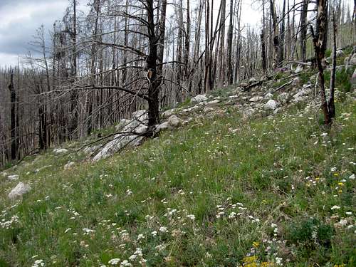
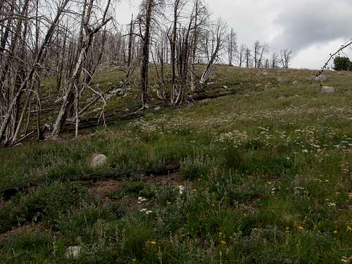
As mentioned, Thunder Mountain has been home to lodgepole pine forests for many years, as it will continue to be for many more years to come. Currently, the mountain forests are experiencing a transition period between dead forests and young regrowth. Animals such as elk, deer, black bear, and cougars are commonly found on the mountain slopes. And interestingly, Thunder Mountain, as well as its immediate surrounding area, is a known permanent residence of the American Three-Toed Woodpecker, a rarity on the east side of the Cascade Mountains.
 Rocky Summit Of Thunder Mountain
Thunder Mountain can be summited by starting at the intersection of Forest Service Road #39 and Road #150 (~6685' elevation). Walk beyond the gate, turn left (north), and do a YDS Class 1-2 off-trail hike north up and along the ridgetop to the rocky summit (7083' elevation), passing by one southern false summit en route. The total hiking distance is approximately 1.5 miles, roundtrip.
 USGS Benchmark Found At Summit
An alternate summit route would be to park alongside Forest Service Road #39 approximately 0.25 miles north of the intersection with Road #150. Hikers can then traverse up the western slope of Thunder Mountain to the ridgetop between the true summit and the southern false summit, before turning north to the summit. This route would be shorter, but would involve crossing a barbed-wire fence, and is not recommended or advised.
Getting There
From Tonasket, WA:1) Drive Okanogan County Road #9437 (Hwy 7) north about 5.5 miles to County Road #9425.
2) Turn east on County Road #9425 and travel about 12 miles to Loomis.
3) From Loomis, continue on County Road #9425 for about 2 miles to County Road #4066.
4) Turn east on County Road #4066, which becomes Forest Service Road #39 (Toats Coulee Road), and continue for 20 miles to Long Swamp Campground.
5) Stay on Forest Service Road #39 by turning south and following for approximately nine miles, until reaching the gated road (#150) on the left(east) side of Forest Service Road #39.
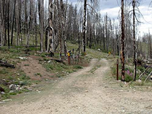 Entrance To Gated Road #150...
Thunder Mountain can be found on Green Trails Map #21.
Red Tape
No passes or permits are required to hike Thunder Mountain.Vehicular travel on Road #150, on the south and southeast flanks of the mountain, is prohibited, regardless if the gate is open or closed. There is enough room to park several vehicles alongside Forest Road 39 near the gate. Do not block the gate.
Below approximately 6500' elevation on the east slopes of Thunder Mountain is the western boundary for the Loomis Natural Resources Conservation Area. Please do not enter that area, as it is being used to help study and preserve the natural rebirth of the forest and its inhabitants.
Camping
Established campsites are found at Long Swamp Campground, approximately nine miles to the north, at the intersection of Forest Service Road #39 and Forest Road #300.Backcountry campsites can be found at Thirtymile Meadows and Thirtymile Shelter, several miles to the north, along Forest Service Road #39.
Current weather conditions in nearby Loomis, Washington (east of the mountain):
