
|
|
Area/Range |
|---|---|
|
|
45.55610°N / 112.03°W |
|
|
Hiking, Scrambling, Skiing |
|
|
Spring, Summer, Fall, Winter |
|
|
10604 ft / 3232 m |
|
|
Overview
Tobacco Root Mountains, Montana
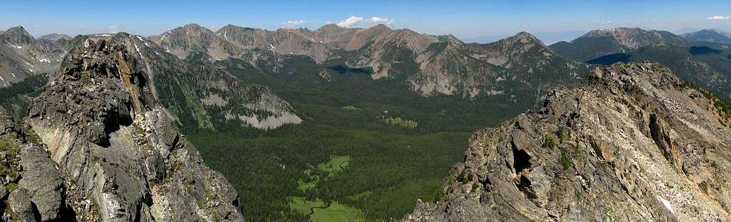
The Tobacco Roots are located in southwest Montana, about 45 miles west of Bozeman, north of the Gravelly Range and west of the Madison and Bridger Ranges. They are located between the Madison and Jefferson rivers. The Tobacco Roots are approximately 26 miles long (north to south) and 18 miles wide. There are numerous high peaks (43 are over 10,000 ft) in this range, with many access roads nearly all the way around and also contains some trails that are open for motorized use. This poses some multi-use controversies in the area, so keep that in mind when planning out a hike or pack trip. The highest peak in the Tobacco Roots is Hollowtop Mountain at 10,604 ft.
The Tobacco Roots generally hold snow at least until early July and are usually accessible until late September or so (without a 4wd), but this will obviously depend on the year. Popular areas accessed from the east end of the range are: Hollow Top and Albro Lakes, Curly Lake, Louise Lake, and Lost Cabin Lake. Each of these trails offer some peak-scrambling opportunities to get off the traveled way, and offer dramatic panorama views throughout the range with picturesque lakes and lush vegetated valleys.
A large portion of the 'Roots are within the Beaverhead-Deerlodge National Forest management. This range has numerous old gold mine claims and prospect sites primarily on the east and west ends, especially near the towns of Twin Bridges and Sheridan, which were most active from the 1880's until the 1930's. There is some ambiguity regarding both the origin of the name "Tobacco Roots" and also the date when this name was first used on geographic maps and atlases. Starting in Hayden's Sixth 'Annual Report' (1873) these mountains have also been referred to as the "South Boulder Range" and then later the "Jefferson Range."
 |
 |
 |
 |
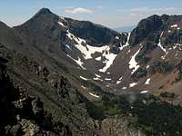
 Middle Mountain, 10,353 ft. Middle Mountain, 10,353 ft. |
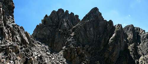
 Backside of Hollowtop Mountain, 10,604 ft. (middle) Backside of Hollowtop Mountain, 10,604 ft. (middle) |
||
For some additional pictures (panoramas), click here.
Highest Named Peaks over 10,000'
Here is a table that shows the top highest-elevation named peaks in the Tobacco Roots:
|
View Larger Map |
Getting There
There are several access points to the Tobacco Roots on nearly all sides of the range. One of the more popular access roads leads close to the middle of the range and to several good trailheads. From I-90, take the exit for Cardwell (should be exit 256), and head south on the rough highway. At about mile marker 6.4, take a right turn on South Boulder Road. This road will eventually lead towards the heart of the Tobacco Roots, past the tiny town of Mammoth. Stay on this road for approximately 14.5 miles. There is a fork at this point, be sure to take the right spur road towards Curly Lake trailhead, and drive another 1.7 miles or so.
From another split in the road you have several options. If you keep straight (right spur) the road will become a 4wd / high clearance road shorty and will eventually lead to a trail heading to Brannan Lakes, and also towards Lakeshore Mountain. If you take a left at this fork it will lead to another trailhead. This trailhead leads up to Louise Lake (and Middle Mountain), or you can take the lower trail which will dump to Lost Cabin Lake.
For additional topographic maps showing more detail for this range, click here.


Red Tape
The Tobacco Roots are located in the Beaverhead-Deerlodge National Forest. Several areas in the Tobacco roots are closed until July 16th for mountain goat kidding. Call the local Beaverhead-Deerlodge Forest office at 406-287-3223 for more info. As with most mountain ranges in this region, black bears and occasionally grizzlies are seen in the Tobacco Roots. Therefore, bear-spray should be carried and proper technique in using the spray and just as importantly, learning how to travel appropriately in bear country are essential here.
External Links
Beaverhead-Deerlodge National Forest: http://www.fs.fed.us/r1/b-d/
"Hiking Montana" Falcon Guide by Bill Schneider and Russ Schneider, 25th ed.
"Montana Singletrack" Beartooth Publishing, 1st ed.
USGS Topographic Quadrangles available in TIFF format can be downloaded via the Montana State Natural Resource Information System here.
USGS Topo Quads (along with other good literature or advice) can also be acquried in hard-copy form from several places in Bozeman including:
Barrel Mountaineering, 240 East Main Street, (406)582-1335
Northern Lights Trading Co., 1716 W. Babock, 1-(866)586-2225
USFS Bozeman District Office, 3710 Fallon St., Suite C, (406)522-2520
Camping
There are several good campsites south of the town of Mammoth, these can also be busy during the weekends. There are numerous options for camping near many of the lakes, Louise Lake is extremely popular with families, but is only 3.5 miles from the trailhead, with not much elevation gain to the lake.
Note
This page is a work in progress... If you have pictures or any additional info you would like to include for the Tobacco Roots please add them to this page. Thank you...
bruceg - Aug 5, 2009 7:59 pm - Hasn't voted
Climbers Guide to MontanaA book written by Pat Caffrey (1986) lists 1150 mountains in Montana. Some information on the Tobacco Root Mountains. Some routes have little information, but it is a great place to start. The book appears to be out of print.