
|
|
Mountain/Rock |
|---|---|
|
|
35.13204°N / 82.9832°W |
|
|
Transylvania |
|
|
Hiking |
|
|
Summer |
|
|
4777 ft / 1456 m |
|
|
Kinda' What I Expected...
Some mountains aren't what you expect.In the southern Appalachians, they quite often aren't what you'd expect. Mountains reaching far beyond the 6,000-foot mark can be tree-covered and viewless while nearby 4,000-foot neighbors can have commanding 360-degree views. Toxaway Mountain doesn't play mind games with you like that.
Situated as it is alongside North Carolina's largest privately owned lake you'd expect it to be covered, nearly to its summit, by gaudy cliff-side homes...it is. As it fails to top 5,000-feet, you'd expect to encounter a tree covered summit...you will. Topped by a handful of radio antennae and one of only two remaining manned fire lookout towers, you'd expect it to be off-limits...it is...kind of.
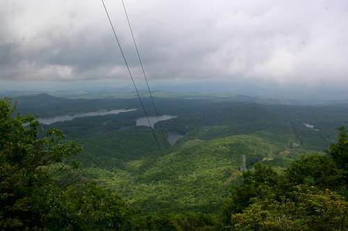 Eastern View
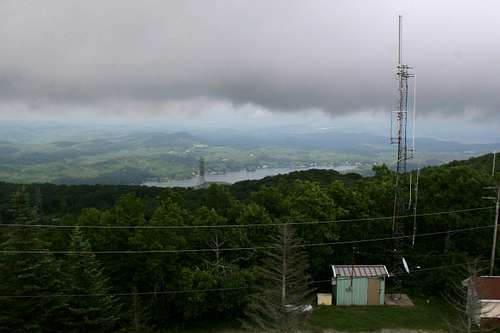 The Summit
I know, so far I haven't made the peak sound real appealing and I guess in a lot of ways its not. Fortunately, the day I visited, I had the good fortune to meet a rather a talkative and amiable USFS worker who was willing (after discovering we shared the same employer) to let me take a quick peak above the trees from the lookout. Also, bordering one of North Carolina's larger bodies of water it commands a unique (in the southern mountains) view of both lake and hill. I won't go right out and recommend you drive out of your way to reach this peak but the unique experience I had led me to believe it deserves a small corner of this site.
Getting There...
 Toxaway Mountain
For the most part Toxaway Mountain is a drive up. You can get within about a quarter mile of the top before you loose pavement and the road gets the least bit rough. However, without a high-clearance vehicle, you won't make it to the tower area at the summit.
From the East:
-Take US-64 through Lake Toxaway.
-A bit shy of 4-miles past the intersection where NC-281 heads south (this would be where you turn for Gorges State Park or Whitewater Falls) look for Tower Road and/or a large blue sign for "Falcon Ridge/Fivestone/Sapphire High" on your right.
-Tower Road heads immediately right and uphill, follow it for 3-ish miles until you loose the houses and the rutted two track to the summit hairpins left. Park here unless you have 4-wheel drive.
From the West:
-Follow US-64 9.5 miles east from Cashiers, then turn left onto Tower Road and follow the above instructions.
 Tower Road
Exploring the Top:
At the actual summit there isn't a whole lot to see unless you're looking to visit another of North Carolina's historic fire lookouts or sit at a nice, stone picnic table listening to the radio antenna's buzz. If you want a view head east past the gate at the hairpin to the summit. You can follow a rather overgrown but easily followed half mile trail beneath some power lines to the steep east face of Toxaway Mountain. From a small overlook wedged into a thicket of Mountain Laurel you get a beutiful view of the greater Lake Toxaway area below. This isn't a wilderness view by any means but the narrow lake tucked into the surrounding hills has its own charm...that is, if you can ignore the power lines dropping down the mountain right in front of you.
Red Tape
 Government Property
Aside from the very real possibility that you will be run off the mountainside by a speeding Hummer along the narrow ascent of Tower Road, there are no access issues.
As stated earlier, the summit is still a working fire lookout station (in the summer), so pay attention to signage and stay off the government equipment!
There's Something to the North...
Spend a bit of time on the trails of the Southern Appalachians and you're likely to hear a fellow hiker/climber speaking in reverent and hushed tones about a magical valley that sits just to the north of Toxaway Mountain that goes by the name of Panthertown...If you too would like to learn more about this hidden (well, not quite like it used to be) southern utopia head here...
 Panthertown
Online Resources...
Nantahala & Cullasaja Gorges Trails Illustrated Map - Although it shows a trail leading to the summit of Toxaway that is actually a road, it is a useful tool to get you to the mountain. Also, it's a must have for other nearby attractions.Hiking North Carolina's Lookout Towers - A book I'm likely to pick up in the near future. Gives detailed info and directions on something like 26 fire towers in WNC (Toxaway Mountain isn't one of them, however).

Click for weather forecast