I gravitate toward the mountains in nearly all of my travels, but this narrative about the American Southeast is sort of the exception. Therefore, it may appear out of place on a mountaineering website. I do not argue otherwise, but I still wish to post it in the same forum as my previous mountain-oriented escapades, for the reading pleasure of those who know me. In short, for any anonymous reader looking for tales of high-altitude adventure, this particular narrative may disappoint you.
This summarizes both a weekend excursion to Alabama & Tennessee in autumn of 2010 and a 2011 winter holiday to Florida & Georgia.
Little River Canyon, Alabama
10/22/10 - 10/24/10
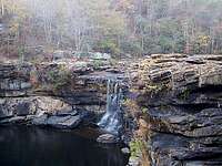
Little River Falls... sort of.
After getting a head start on this quick weekend trip the night before, I left a Tennessee rest area on a bearing for the Little River Canyon and its potential for terrific fall foliage scenery. Shortly after I entered northern Alabama, I crossed the wide Tennessee River and reached the outskirts of the southern Cumberland Plateau. The hills of the land began to rise more dramatically, the visible rock began to increase, and soon I was on Lookout Mountain. The Little River itself sort of caught me unprepared when I was suddenly crossing the highway bridge over it, and I was even more surprised when I pulled over to walk down for a closer look at Little River Falls. The water volume was drastically low, not far from completely dry, and the falls were reduced to a few small trickles. The contrast between the current dribbling state of the river and the large riverbed cavity in the rock was particularly striking. It evoked imaginary visions of just how powerful these falls must appear in times of high water.
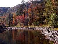
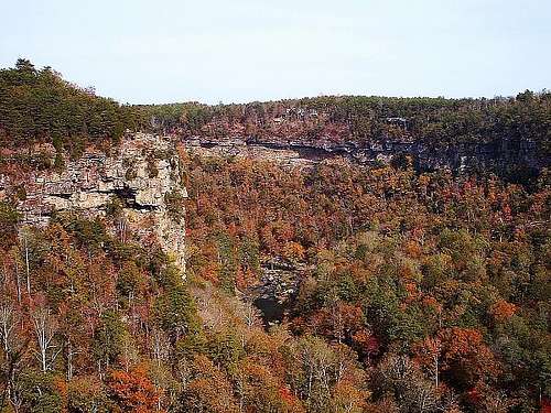
I traveled downstream from the falls in search of a wonderful autumn photograph by the river. My first access to the river was via the Powell Trail, roughly midway between the falls and the canyon mouth, all of which lies entirely on Lookout Mountain. Here I picked up a nice walking stick to help me descend, one straight and sturdy enough that I decided to keep in my car for future use. I found the river bank here to be much like the falls upstream, very low on water. It was not really a river in this state, rather just a series of occasional reflective pools. I hiked up and down the banks both ways and picked up a few good looks. From there, I drove slightly back upstream for access via the Eberhart Trail and some similar photos. My favorite views came from the high overlooks at Eberhart Point and Wolf Creek, where the canyon walls provided a great compliment to the orange and yellow foliage.
Autumn views along Alabama's Little River.
Eberhart Point Overlook.
Wolf Creek Overlook.
I wanted some pictures with vibrant red color, and I found that farther upstream. The Lower Two-Mile Trail provided some very direct access as an unconventional trail. I would call it a climb more than a trail. I needed my hands early and often to navigate to the bottom. Awaiting me at the river bank was quite a reward, a beautiful and intact section of the river with bright red and pink leaves in the distance. The light conditions were not advantageous, but I was still thrilled with the scene. Here I grabbed a souvenir rock and soaked in the sights during a peaceful, unhurried snack from my backpack. When I began to think about a place to camp late in the evening, I first tried Desoto State Park, but I was politely turned away. They recommended a private campground a few miles farther north, so I took the advice and found it very near the Georgia state line. The entrepreneur of the campground was exceedingly talkative and polite, and he set me up with a nice campsite.
Powell Trail at the river.
Lower Two-Mile Trail at the river.
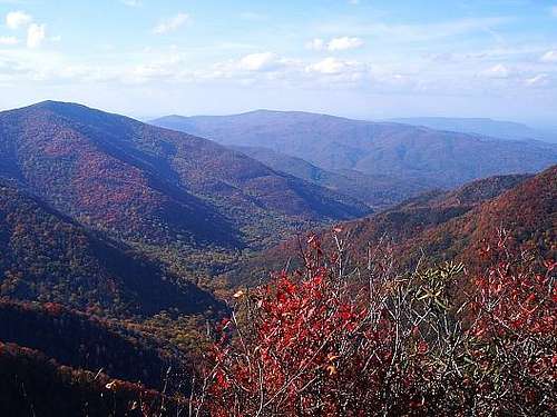
A warm shower facility felt wonderful on the following chilly morning, and afterwards I ventured northeast into Tennessee for a scenic detour through the Smokies. Just east of Chattanooga, I hopped on the Ocoee Scenic Byway to circle around the Smokies from the east. The road was a wonderful route winding through the Cherokee National Forest beside the Ocoee River. It even took me to the site of the Olympic whitewater rafting events in 1996. This was a cool discovery; I had no idea beforehand. I entered the Smokies from the east, after traveling the Great Smoky Mountains Expressway northeast into North Carolina. The roads were swamped with slow-moving travelers, so I was pretty eager to get out and about when I reached Newfound Gap. In the hour I had there, I ambled around on the Appalachian Trail for just long enough to keep me indistinguishable from the typical car-bound tourist. There was just not the daylight to do much more. From there, I moved west into Tennessee for another hike on the Chimney Tops trail. This was the first mountain I hiked three years ago, and this visit was just as enjoyable as the first. The summit view of the neighboring fall foliage was tremendous. Many spots of the deciduous forest were peaking in dark reds and oranges. I ended up having a snack and staying a little longer than my itinerary allowed, but I could not help it because of the beauty. The cost of my extended stay was a planned glance at Cumberland Gap. By the time I got to Kentucky, it was entirely dark, so I just drove back home through the rest of the night.
Fall colors on the adjacent valleys of Chimney Tops.
Cumberland Island, Georgia
12/26/11 - 01/01/12
Apalachicola Bay.
Sanibel Island.
My long-standing plans to welcome the New Year on the Atlantic beaches were enhanced by more recent invitations to play with friends in Florida, making for a full week of activity. An hour or two after midnight, I fumbled through my gear, loaded my car, and started for Florida. A few minutes later, I turned around to get the rest of my needed gear and start again for Florida. In Indiana, I paused at a rest area where I was destined to waste further time. A creepy stranger said he needed a ride to a gas station, and I reluctantly obliged just the ride away, not the ride back. With those uncomfortable moments out of the way, I crossed into Kentucky and observed the first indications of morning light to the east. In the full Alabama sunshine, the longleaf pine flora really took me by surprise; I had unknowingly expected deciduous forests. It was another one of the neat discoveries that can accompany travel to new places.
My drive across the Florida panhandle took longer than I estimated, and in short, I failed to reach the Apalachicola National Forest in time. The night had arrived before I could, along with a solid rain. The recreation areas of the forest were already gated off for the night. Now I needed to improvise. A half-mile from my Camel Lake campground, I spotted a faint opening in the forest illuminated by the periphery of my headlights. It was apparently an off-road vehicle trail, not really suitable for a car, but just wide enough for mine. Very carefully, I eased my two-door coupe into the pines. The rain showed no signs of relenting, so I left my tent unused and I curled up in the back seat.
A late arrival was likely a hidden blessing for me, because the skies unleashed some significant wind and heavier rain throughout the night. In the morning, once I gingerly backed my car out of the heavy slash pine forest, I visited the Gulf of Mexico. The beaches here were not gifted with striking beauty. Minimal sand was a dirty tan color, with mysterious spots of black slime about the size of a fist. It seemed simple to assume oil, but the Deepwater Horizon spill was already a year gone by, so it is hard to say for sure. I moved on fairly soon, passing through the undeveloped forests of Florida’s lesser-populated areas. Late in the afternoon, I arrived in town to a hearty welcome from my friends and set up my tent in their sandy backyard. Their house was full, but the pleasant temperatures were ideal for outdoor sleeping anyway.
On Sanibel Island the next day, the thick beach stretched out for miles, littered with more large shells than you typically find on a developed beach. I took a white shell as a souvenir. The ocean water was pretty cloudy with sand, being churned up by moderate wave activity, but it was the warmest that I have encountered. Neighboring beachgoers never seemed to join, though I merely paid them only fleeting attention. With that said, however, it is amazing how you can still perceive certain actions by others, even when you are not focused on them. A moment came where I heard some commotion on the beach nearby, so I curiously scanned around to see what was going on. To the southeast, in the water about twenty yards from me, I saw that trademark gray dorsal fin. It was a shark, moving roughly parallel to the shore toward my swimming area. It seemed like I was a little bit offshore, but I managed to quickly establish a footing on the bottom, and I bravely scurried out of the ocean in haste. Just as I emerged, I was greeted by one concerned tourist running down the beach, warning me of the shark in the water. I was thankful for her concern, though I felt a bit guilty inside, because in a role reversal I probably would have just stood and watched. Needless to say, that was enough swimming for me on this beach holiday. We left soon thereafter.
Late in the morning of the next day, we decided to stay more local and visit a beach farther north. The water here was clearer than at Sanibel and it was free of sharks, possibly because it happened to be much colder. I never adapted to it in a level of real comfort. We did not linger here as long because my friends needed to be on their way in the afternoon, and I settled for a very early bedtime around nightfall. This was a day of pretty low activity. I mostly waited for the early morning start toward my next destination.
Cumberland Island's maritime forest.
Cumberland Island's undeveloped seashore.
For the second time this week, I was awake and moving several hours before sunrise. About half of Florida, south-to-north, separated me from Cumberland Island National Seashore. I may have been unable to see anything in the night, but I am sure I passed through some nice Ocala National Forest scenery along the way. Just past this national forest, daylight began to appear for me around the Jacksonville area. I reached the Georgia state line at the Saint Mary’s River, and since Cumberland Island is the absolute southeastern tip of the Peach State, I was at the ferry terminal in quick time.
I was almost early enough to take the previous boat on the schedule, but I just missed it. After partaking in some breakfast and idleness for two hours, I boarded my ferry for a voyage up the Saint Mary’s River. Right after the launch, a few dolphins appeared just to bounce up and down alongside the boat for a mile or so. After they vanished, the boat winded through salt marshes on either side to open Cumberland Sound, and eventually to the island dock in forty-five minutes. There was a massive pile of gear at the front of the boat, but I chose to retain my pack to enable a quick escape at the dock. The time I saved by not sifting through the gear pile was instead used to wait for my backcountry registration, as the ranger would not register the overnight campers until everyone else grabbed their gear. My clever, foolproof plan was foiled, and I had to wait for some time.
Once I reserved my two nights at Stafford Beach, I was then able to start northeast on the Parallel Trail. The island greeted me with a packed maritime forest of live oak canopies and bright green saw palmetto underbrush. Given its name, this trail stays an even distance from the shore, so the forest stayed consistent as I covered the four or five miles to my camping area. The proximity to the salty ocean breezes makes a profound impact on the island vegetation. The forest canopy is at its highest on the interior, and it seems to slide lower as the trees approach the beach. At my campsite, I set up my tent beside one typical oak specimen sprinkled with Spanish moss. The tree’s lowest branches were too big to put my arms around, yet they only hovered just above the ground, sprawling in all directions. In the last hour or two before sunset, I walked through the shrubs and bushes of the interdune meadows toward the Atlantic. Several inlets carved into the beach around sand patches momentarily exposed to the sun near low tide. Among the many shells dotting the shore, I also saw two stranded jellyfish glowing in unique pink translucence. Being a true student of exploration and discovery, I found a stick and poked them until I was content. That was the most interesting part of my short evening stroll, and I waited until the next day to fully explore the wild beach.
Interior beach dunes.
The beach wall.
Inland marshy areas.
Sunrise through the forest.
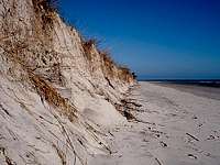
Sunset broke through the oaks on quite a mild morning for the heart of winter. Sometimes this beach can hold snow around the New Year, and other times it can warm into the sixties. During this visit, I was blessed with the latter, enabling a comfortable long walk around the island. I supplied my backpack and walked north for a few miles to the rough midpoint of the island coast. Cumberland Island is a rare example of undeveloped, natural ocean beach. Well, when I say natural, I mean as natural as a beach can be in the industrial world. A staggering amount of refuse lied on the dry sands away from the surf. There was everything from the ordinary - fishing nets, ropes, and processed wood - to the unusual miniature refrigerator or automobile tire. I have heard there is no beach in the world without human trash, and this reinforced the idea for me.
The solitude of this beach was startling and wonderful at the same time. It is relatively easy to find seclusion in the mountains, but generally more of a challenge at the ocean. Only after a few hours did I spot tiny figures of any other visitors, miles away to the south near the ferry docking points. Footprints in this area were few and far between, but seashells and sand dollars were abundant. As a souvenir, I picked up one scallop shell that shined particularly bright. The afternoon was a relaxing time to comb the beaches, snack on food, and read a book during a dance with the rising tide. Every few minutes, a presumably sufficient dry space between the waves and me would suddenly be overrun with water, and I would scramble back a few steps. Those crashing waves and some inquisitive seagulls were the only sounds in the air.
For those coming into shore.
Palmettos by the sea.
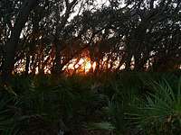
The year's first sunrise on Cumberland Island.
On the way back south to my Stafford Beach campsite, I surveyed some of the interior dunes and meadows along the progression from beach to forest. Sand oats are the closest vegetation to the sea, and their roots make it easier for the beach sand to withstand erosion. The result is a barrier of sand that, in some places, stands surprisingly tall as a large wall. An occasional palmetto grows on the land side of this barrier, but it is mostly a sea of beach grasses and shrubs that blend into the maritime forest farther inland. Near the camp, I finally encountered a few other tourists in person. The beach felt like it was mine throughout the day. I went to bed early to greet the sunrise.
Just as the night began to relent, I walked out to the deserted beach to watch the New Year’s first sunrise over the Atlantic. Clouds on the horizon obscured the first light just a little bit, but the direct sunlight rose above them in minutes. I admired the sight, snacked on a small breakfast, and headed back to my campsite to pack up. I had a long day ahead of me. My ferry back to the mainland was the first one scheduled for the morning, and I waited for it alongside many other visitors. Some groups numbered in double digits and needed wheeled carts to carry all of their supplies. I do not know where they all were yesterday; I hardly saw anyone. Anyway, the ferry ride was another treat, and I started my drive back home just before noon. I traveled through most of Georgia on quieter rural roads before I utilized the highways on the remaining route, concluding just after midnight.