Göran Kropp of the Rockies to Attempt Mount Sir Alexander
By Chris Goulet
Printed in the August 12, 2008 edition of the Mountaineer, the local newspaper for Grande Cache, Alberta, Canada.
![Mountain bike and home-made trailer in the Atacama desert]() Mountain bike and home-made trailer in the Atacama desert, going to climb Ojos del Salado, Chile/Argentina. The same equipment was used to approach Mount Sir Alexander, British Columbia in 2008.
Mountain bike and home-made trailer in the Atacama desert, going to climb Ojos del Salado, Chile/Argentina. The same equipment was used to approach Mount Sir Alexander, British Columbia in 2008.
Who’s Göran Kropp? He was a crazy Swede who decided that Mount Everest was way too easy to climb normally. To make it more interesting, in 1996 he cycled from Stockholm to the Himalayas with 110kg (240lbs) of gear and climbed to the summit without bottled oxygen nor Sherpa support.
Inspired by such purist insanity, I dusted off my home-made bicycle trailer and decided that I’ll be mountain biking from Grande Cache to Mount Sir Alexander in the Kakwa Provincial Park in BC via back-roads and cutlines with my mountaineering gear and 24 days of supplies. A week-long scout of the route via the Copton Creek trail to the Kakwa River ended in a tangle of deadfall on the so-called ‘truck road’ described in the Kakwa Wildlands brochure. What they had forgotten to mention was that the river had cut huge gashes across the track, and no one had maintained it in ages.
The expedition was back to Rick Drummond for plan B. We surrounded ourselves with piles of maps and scoured digital gasfield maps to outline a 210km (130mi) route further North that includes the Beaverdam and Copton roads, wading across the Kakwa River, then the Porcupine and Red Rock roads, a cutline, the Bowen Road, the Two Lakes Road, and finally the Tote Road to Kakwa Lake BC. From there it’s a hop to the Saddle Creek where I’ll hang the bike to save it from rubber-nibbling porcupines, and set off backpacking with the climbing gear and two weeks of supplies, which should be long enough to wait out any snowstorm. That was the lesson learned on last year’s attempt, which was hampered by four days of white-outs, needing to drag an inflatable kayak and paddle to cross the McGregor River, and bushwhacking tangled willows and devil’s club, while doing a tight-wire act on logs on top of logs on top of... well you get the point. Ten days of supplies just didn’t cut it. This time I’ll be trying the Saddle Creek, which is a Southeast approach; it may be easier bushwhacking than the Southwest approach tried last year, and there’s no river crossing.
Mount Sir Alexander is only 83km (51mi) from Grande Cache as the raven flies. We can’t see it from town, but it’s an impressive peak of 3275m (10745ft) in elevation, and is seen by thousands of Grande Cachites from the summit of Mount DeVebre, a gold-level ‘Passport to the Peaks’ mountain 41km (25mi) up the Smoky River valley. Oh, did I mention that most of those Grande Cachites are ravens? Mt. Sir Alex is surrounded by glaciers, and looms over bastion-like walls. It is the Southernmost main peak of the Hart Ranges and rises higher than all surrounding peaks as far as the eye can see. Exposure to falling debris is severe on most routes.
The peak was first identified as Mount Kitchi, which is a Cree word for "big" or "great", by climber Mary L. Jobe and her guide Don ‘Curly’ Phillips in 1914. They attempted the climb in 1914 and 1915. Mount Kitchi was renamed to Mount Sir Alexander in 1917. Due to its inaccessibility and because it was declared unclimbable in 1922 after a fly-by, it was left unclimbed until American doctor, Andrew Gilmour reached the summit in 1929.
My good friend and ex-Grande Cachite ‘old’ Bill Latimer, who has completed the gold ‘Passport to the Peaks’, joked that the program should be extended to include ‘platinum peaks’. This is a budget trip, so Mount Sir Alexander will have to settle for iridium, literally. I’ll be leaving a five-gram pellet of pure iridium metal on the summit as an offering if the mountain allows me there. It’s the most corrosion-resistant metal known, and is very hard, so the pellet could last millions of years, possibly longer than the mountain itself. Mind-boggling.
Departure is set for August 7th, returning to the Two Lakes Road on August 30th. Why solo? Who would spend 3 1/2 weeks on my purist obsession? Maybe I’ll go with my climbing buddies and climb it ‘normally’ someday, helicoptering to the high glacier, and make it a day-hike. But this time, my crevasse probe will be testing every step, like it did on Mount Robson in 2006. Stay tuned for the rest of the story in September.
Göran Kropp of the Rockies Foiled by an Icefall on Mount Sir Alexander
by Chris Goulet
Printed in the September 16, 2008 edition of the Mountaineer, the local newspaper for Grande Cache, Alberta, Canada.
Lying in the cramped, damp tent, heavy with snow, by a little lake at 2440m (8000ft) elevation, blanketed by fog so thick, I could barely see the opposite shore 60m (200ft) away, I’m reading Mary Jobe’s magnificently written account of her attempt on Mount Sir Alexander with Donald ‘Curly’ Phillips in 1914. About this very spot, she wrote:
“I stood in a new world, somewhere between earth and heaven. A huge ice peak, sheer and terrible, rose straight in front of me. From the base the eye traveled up a steep snow slope to perpendicular rock cliffs, deeply notched with chimneys; it traveled from ice field to higher cliffs, more formidable than those below, and at last rested on the cold blue of an austere mountaintop, a pile of broken ice and demolished snow cornices...The arête was everywhere broken and knifelike. ‘I’d rather take you up Mt. Robson TWICE,’ was Phillip’s only comment. ...The mountain was obviously impossible to our two selves with our limited equipment.”
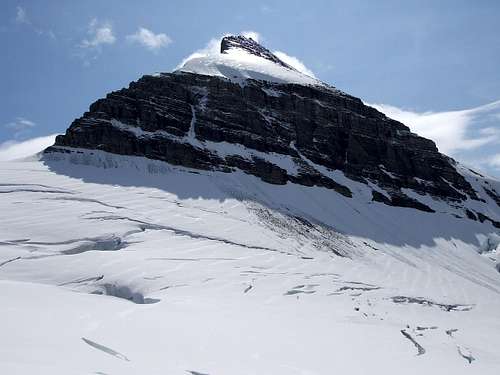
![North face of Mount Sir Alexander]() North face of Mount Sir Alexander, showing rockfall and avalanches. The jagged NE ridge that Mary Jobe described above is to the left.
North face of Mount Sir Alexander, showing rockfall and avalanches. The jagged NE ridge that Mary Jobe described above is to the left.![Mary Jobe and Donald Curly Phillips cairn on Mount Sir Alexander]() Cairn at 2440m (8000ft), probably erected by Mary Jobe and Donald 'Curly' Phillips in 1914.
Cairn at 2440m (8000ft), probably erected by Mary Jobe and Donald 'Curly' Phillips in 1914.
The hardships along the way for me to get here pale in comparison to those on Jobe and Phillips’ six-week journey from Jasper equipped only with early outdoor equipment. After every attempt on the peak, they had to descend all the way back to tree-line for firewood. Nonetheless, my 184km (114mi), 8-day bicycle trip from Grande Cache and 53km (33mi) 6-day backpacking approach via back roads, cutlines and bushwhacking flooded my memory with challenges. The route was so rough that my home-made bicycle trailer, which had survived traverses of the Andes, suffered one disaster after another. When the frame sheared right off, I was afraid the expedition was over. But I MacGyvered a fix that required fabricating a drill bit by grinding a spare screw over rocks, then clamping it with the Vice-Grip to drill holes by hand into what was left of the frame tube. It took a full day’s work, my wrists were sore, and the trailer became two inches shorter, but it was in one piece. Later, both tires blew off the rims, their bead cables having fatigued and snapped. A quadder stopped by, dug into his box and pulled out...tie-wraps of perfect length! A dozen of them on each wheel kept them together, and I pushed on to Dead Horse Meadows, near Kakwa Falls. Ten horseback riders had just completed a two-week trip in the Alberta and BC Kakwa parks, telling animated stories over a feast of food. But I soon discovered that the Kakwa trail from there into BC, which had been closed to quads for decades, is a muddy quagmire and deep horse ruts made the bicycle approach plan impossible. So I hung the cycle gear from a tree to protect it from porcupines, and hoofed it, all 39kg (85lbs) including 17 days of supplies. The trail passes by Kakwa Lake, one of the most splendid places in the Rockies, then it presents breathtaking views of Mount Sir Alexander.
![Bicycle and trailer on cutline]() Bicycle and trailer on cutlines between Red Rock Road and Bowen Road, Alberta on approach to Mount Sir Alexander, British Columbia in 2008.
Bicycle and trailer on cutlines between Red Rock Road and Bowen Road, Alberta on approach to Mount Sir Alexander, British Columbia in 2008.![Sheared frame on home-made trailer used to approach Mount Sir Alexander]() Sheared frame on home-made trailer, but I MacGyvered a fix.
Sheared frame on home-made trailer, but I MacGyvered a fix.![Both tires blew off the rims on the way to Mount Sir Alexander]() Both tires blew off the rims, but a dozen tie-wraps on each wheel kept them together.
Both tires blew off the rims, but a dozen tie-wraps on each wheel kept them together.![NE face of Mount Sir Alexander]() NE face of Mount Sir Alexander as seen from the Walker Forestry Road.
NE face of Mount Sir Alexander as seen from the Walker Forestry Road.
As the fog thinned over my camp at 2440m (8000ft), I caught glimpses of the ‘huge ice peak, sheer and terrible’ and spotted the glacier that I planned to climb on the Northwest side of the mountain to approach the Southwest ridge. I believe the Southwest ridge is only sane route up the summit pyramid, because the rock strata are more aligned with the slope of the ridge, making less of a sawtooth than on all the other ridges, including the one that so terrified Mary Jobe and Donald Phillips. But first I had to get up the Northwest glacier to get over a long bastion of rock cliffs. This route was chosen just from studying the map, because after extensive research, I couldn’t find any published route. It looked BAD. A gaping bergshrund crevasse spans the entire width of the glacier, and there’s an icefall on the left. Oh well, I’ll just have to get up close and personal, maybe there’s a sneaky way up. I snapped on the crampons, and traversed the icefield to the base of the icefall, probing every step by ramming the crevasse probe into the snow, feeling for air. It was too late to tackle the icefall, but the fallen rocks and ice blocks would have made this a dangerous campsite, if it weren’t for a colossal crevasse that was guaranteed to swallow up any debris or avalanche coming this way.
![NW slopes of Mount Sir Alexander]() NW slopes of Mount Sir Alexander as seen from 2440m (8000ft) camp. The steep glacier with the gaping bergshrund crevasse in the middle of the photo was the planned route.
NW slopes of Mount Sir Alexander as seen from 2440m (8000ft) camp. The steep glacier with the gaping bergshrund crevasse in the middle of the photo was the planned route.![Camp on Mount Sir Alexander by a colossal crevasse]() Camp by a colossal crevasse that was guaranteed to swallow up any debris or avalanche coming this way.
Camp by a colossal crevasse that was guaranteed to swallow up any debris or avalanche coming this way.
The next day, the weather was half-decent for the crux of the approach, so I zig-zagged around crevasses, quickly crossing debris paths, and came face to face with the problem. No way, no sneaky way. Blocks of ice 70-80 degrees steep loomed in the entrance to the chaotic pile of broken ice. And there was a three-foot wide crevasse to cross, with a one-foot higher lip on the other side. It looked terrifying. This was over my risk tolerance. Expedition number two was likely over. Two other options now were long-shots. Maybe I could go several kilometres around and thousands of feet down the bastion wall and back up again, but now being five days behind schedule, supplies were too tight to do this. Or I could go all the way around the upper glacier to attempt to climb the Nilah Pass on the South side of Alexander, but we’d seen a small cliff at the base of it from Dale Tuck’s plane last year. Oh well, it would be an awesome trek anyway. So I lumbered up the icefield, and circumnavigated 3/4 of the way around the summit pyramid on the high glacier at 2700m (8900ft) elevation. I was treated to mostly cloud-free vistas of several insane sawtooth ridges leading up to the 3275m (10745ft) summit. Sure enough, Nilah Pass was impassable, but the 50m (150) high tower at the pass is very impressive. I had a magnificent camp just below it on the wide, smooth glacier with curved streaks of pink algae on the snow. However, it was a rough night with 90km/hr (55mi/hr) wind gusts slamming the tent and bending two poles, with unexpectedly calm moments in between gusts.
![Route taken to the base of the icefall on Mount Sir Alexander]() Route taken to the base of the icefall.
Route taken to the base of the icefall.![Seracs loomed in the entrance to the terrifying icefall]() Seracs loomed in the entrance to the terrifying icefall, which foiled my second attempt on Mount Sir Alexander on Aug 23, 2008.
Seracs loomed in the entrance to the terrifying icefall, which foiled my second attempt on Mount Sir Alexander on Aug 23, 2008.![Looking down an icefall on Mount Sir Alexander]() Looking down an icefall.
Looking down an icefall.![Vast icefield to the West of Mount Sir Alexander]() Vast icefield to the West.
Vast icefield to the West.![Tower and cliff at Nilah Pass by Mount Sir Alexander]() Tower and cliff, which twarted getting over Nilah Pass.
Tower and cliff, which twarted getting over Nilah Pass.![Enormous icefall Southeast of Mount Sir Alexander]() Enormous icefall Southeast of Mount Sir Alexander.
Enormous icefall Southeast of Mount Sir Alexander.
With supposedly enough time remaining, I decided to do the ‘scenic’ route for the return journey to Kakwa trail. I went Northeast, passing by Mount Ida (3140m or 10300ft), then close to Jarvis Lakes. The planned route goes over five passes, and I didn’t know if any of them are passable. The first one was partway over Kitchi Mountain. I was stranded by at 2600m (8500ft) elevation in a whiteout, not having a clue how (or if) I could get down. After an hour, I got a fleeting view in between clouds, and prepared for a steep front-point crampon and double ice-axe descent, weaving between crevasses. I crossed a marvellous glacial valley with the white bedrock polished clean by the recently receded glacier. The floor was in a gentle sawtooth pattern and made a beautiful campsite. The problem was that it rained so much that night that a stream formed in the trough of the sawtooth and passed under the tent! I put the backpack over it, and tried to ignore the gurgling noises. The next pass required another long front-point descent, but it bought me to a place I had dreamed about for a long time. It’s a place where creeks from several lakes converge and are swallowed up in an abysmal sinkhole. I found a steep scree slope leading down the crater-like depression, and scrambled under the dripping snow roof and into the dark hole, right to edge of the abyss, with the thundering waterfall echoing on the rock walls. Cavers had gone down 200m (700ft) below the waterfall and had discovered that the cave system is vast and could be the longest and deepest in Canada.
![Moon River Cave, near Mount Sir Alexander]() Water cascading into the Moon River Cave, near Jarvis Lakes.
Water cascading into the Moon River Cave, near Jarvis Lakes.![Moon River Cave, near Mount Sir Alexander]() Water cascading under a snow roof at the entrance to the Moon River Cave.
Water cascading under a snow roof at the entrance to the Moon River Cave.![Water tumbling into the abyss of the Moon River Cave]() Water tumbling into the abyss of the Moon River Cave
Water tumbling into the abyss of the Moon River Cave
To my horror, the Jarvis Mountain pass was in fact an impasse of rock cliffs and no snow. In a deluge of wet snow and hail, whipped by a howling gale, adrenaline kicked in and I skirted several kilometres on loose scree, climbed over the ridge, and rapelled from trees on a vertiginous zig-zag route, following the only line of trees down the cliffs. Now getting late for my pick-up date and low on supplies, I was travelling twelve hours per day. Bushwhacking in the wet forest, I was drenched to the bone, and I drained a pool of water from my boots by lifting a leg up occasionally. To my distress, even my sleeping bag had gotten wet. The next day, I made it to the Kakwa Trail and dug up my food cache. The twenty minutes of sunshine that day was a godsend, just about drying out my sleeping bag. Finally arriving at the bike cache close to Dead Horse Meadows, my sweet friend wasn’t there because the Two Lakes Road had become a muddy quagmire. So I sent a message down to her via a quadder, then biked down the wet rocky track to Lick Creek. Another quadder stopped by to tell me that she got the message and is waiting for me. It was a splendid reunion and I appreciated her for driving from Grande Cache and the long, bumpy road from Grovedale. So ends this 25-day expedition (Aug 7-Sept 1, 2008). But as the Terminator would say, ‘I’ll be back!’.


Comments
Post a Comment