Finding the Clear Creek CG
Most of the directions given in publications and on this site are accurate. I will add only a couple of items to help you avoid "traps." If you are driving from the south, take the 2nd Snowville Exit. The 1st one will not connect you with Highway 30. If you are driving from Salt Lake City, the distance to the Clear Creek TH is approximately 145 miles. When you get to the CG be sure to take a left and actually enter the area; the road continues straight but dead-ends at private land. The CG road snakes left, passes a restroom and then makes a 180 degree turn before you find the loop at the TH.
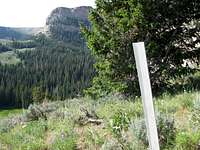
![Bull Mountain]() Sign at the TH
Sign at the TH The early hike and possible time predictions
Plan on plenty of opportunity for shade during the first hour of the hike. You begin in gently sloping landscape with rocky ATV ruts serving as your trail. On your left the creek sings to you. After 15 minutes you will see another sign "Bull Flat," and a trail leading off to the right. Continue straight ahead.
![Bull Mountain]() After 15 minutes - go straight.
After 15 minutes - go straight.![Bull Mountain]() Take this trail to the right.
Take this trail to the right.About 30 minutes into your hike and after crossing a short muddy area you will see another sign "Lake Creek." Others have referred to this trail as the Lake Fork Trail, and that may very well be the truth. But the sign says nothing about Lake Fork as you can see by the accompanying picture. This trail takes a 90 degree right turn and heads up. Take this trail and prepare for about 25 minutes of sometimes steep travel. On this route you soon angle left and begin paralleling a creek (Lake Creek?).
At about the 55-minute point you will drop down and actually cross the creek. On the west side of this creek, nailed to a tree, you will then see the sign labeled "Lake Fork No 6004."
![Bull Mountain]() Sign at the creek crossing. You must cross the creek first, then look for the sign.
Sign at the creek crossing. You must cross the creek first, then look for the sign. From the approach side of the creek it is nearly impossible to read this sign or even know it's there. This crossing is at an elevation of approximately 8,000'. If you have a GPS, this is an excellent waypoint to enter, for from here on the trail is less than optimal and difficult to follow.
The second half of the ascent to the summit
I call the stream crossing the first half of the hike. It is probably a little less than half way, but it's close enough. It is from this point that the "trail" is more of a dream than a reality. So few people make their way along it that the vegetation shows little if any sign of use.
In general the way almost parallels the creek below to the left, but at the same time climbs gently away from it as it leads toward a stand of pines and aspens. In the trees a trail can be found, but at the other end of the forest I could not find any recognizable trace of a way through the thick sage brush and ground-hugging vegetation. I could see the east end of the cirque, however, and I had the summit lat/lon in my GPS, so I continued in the general direction, making only adjustments for deadfall and particularly vicious stands of gnarly brush. It was enough to make a grown man scream, that bushwhacking, and one must fight to avoid the desire to set fire to the entire sea of tentacles grabbing for every limb you have exposed.
![Bull Mountain]() After aggravating bushwhacking the Bull Lake cirque area is a welcome sight.
After aggravating bushwhacking the Bull Lake cirque area is a welcome sight.
After almost 50 minutes of fighting and battling I had a fine view of the cirque surrounding Bull Lake, more a brilliant green sea of verdant grasses ringed by pine trees than an actual lake. The picture indicates the treat in store for those willing to be patient and take the bushwhacking like a man (or a woman, for that matter). And, sure enough, to the right was a rocky ledge of a trail leading up to the stand of pine trees at the upper edge of the cirque.
![Bull Mountain]() Important white marker at the top of the trail leading up from the west side of the cirque.
Important white marker at the top of the trail leading up from the west side of the cirque.
It was at the top of the rocky trail that I encountered the white slat stuck into the ground, and I am glad I noticed it. On the way back down it helped me to locate the trail leading back down into the cirque. I was startled by a humongous black cow, bright red ear tag dangling, and I gave this animal wide berth. Then it was back to bushwhacking through two separate stands of timber and additional rocky tundra-like climbing terrain before I spotted what looked like a jeep trail ahead and to the right.
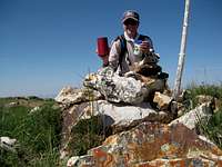
The summit plateau came into view and soon the make-shift cairn, marking pole and obvious highpoint. Shortly before the highpoint landmarks I had to cross a cattle guard which was bounded on both sides by a high barbed wire fence. Wildflowers added dainty colors to the otherwise drab landscape. I reached the "summit" two hours and fourteen minutes after leaving the TH.
![Bull Mountain]() At the summit with its cairn, pole and unusual ivd register paraphernalia.
At the summit with its cairn, pole and unusual ivd register paraphernalia.The climb down the mountain.
![Bull Mountain]() A view northwest as you leave the summit plateau.
A view northwest as you leave the summit plateau.![Bull Mountain]() Finding the stream crossing with the help of GPS was comforting.
Finding the stream crossing with the help of GPS was comforting.Not much to say about this except that using GPS waypoints to find important landmarks or trail points was extemely helpful. Once I reached the point north of the cirque, I plunged back into a trail-free wasteland of sage brush, undergrowth and deadfall-plagued treed areas which never yielded any hint of even my recent trail-breaking efforts. Still, I made excellent time going down in spite of the constant threat of twisting an ankle or cart-wheeling headfirst into unforgiving dead limbs. I was ever so grateful that I had marked the stream crossing as a waypoint. The giant mushroom shown here is only one example of the many over which I passed when in the forested areas.
![Bull Mountain]() Plunging through fertile forest areas proved interesting from a botanical standpoint. Lunch anyone?
Plunging through fertile forest areas proved interesting from a botanical standpoint. Lunch anyone?
Once at the creek crossing I removed my boots and socks, gave my dogs a cool bath and meticulously removed the dozens of forget-me-not burrs from my war-torn socks. Have you ever had those little burrs commit mayhem with your socks and pant legs? It ain't pretty, but to get them out is the best thing, provided you have the time.
The remainder of the descent was straightforward and pleasant, even with the summer temperatures approaching 90+ degrees. I have found that quoting poetry helps to pass the time during an otherwise dull return to the TH. The entire descent including the abbreviated but soothing foot-bath and the sock rejuvenation took less than two hours.
Here are three important waypoints; all readings are from my GPS:
TH (actually 200 yards along from the TH) N41 57.054 W113 19.319 (6,320');
Lake Creek crossing N41 55.690 W113 20.460 (8,004');
Summit cairn N41 54.682 W113 21.959 (9,956').


Comments
Post a Comment